Loading AI tools

Town in Baden-Württemberg, Germany From Wikipedia, the free encyclopedia
Schramberg is a town in the district of Rottweil, in Baden-Württemberg, Germany. It is situated in the eastern Black Forest, 25 km northwest of Rottweil. With all of its districts (Talstadt, Sulgen, Waldmössingen, Heiligenbronn, Schönbronn and Tennenbronn (since 2006)), it has about 22,000 inhabitants.
Schramberg | |
|---|---|
 Coat of arms | |
Location of Schramberg within Rottweil district 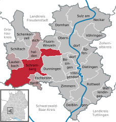 | |
 Schramberg  Schramberg | |
| Coordinates: 48°13′37″N 08°23′03″E | |
| Country | Germany |
| State | Baden-Württemberg |
| Admin. region | Freiburg |
| District | Rottweil |
| Subdivisions | Town centre plus three districts |
| Government | |
| • Lord mayor (2019–27) | Dorothee Eisenlohr[1] (Ind.) |
| Area | |
| • Total | 80.70 km2 (31.16 sq mi) |
| Elevation | 424 m (1,391 ft) |
| Population (2022-12-31)[2] | |
| • Total | 21,125 |
| • Density | 260/km2 (680/sq mi) |
| Time zone | UTC+01:00 (CET) |
| • Summer (DST) | UTC+02:00 (CEST) |
| Postal codes | 78142-44, 78701–13 |
| Dialling codes | 07422 |
| Vehicle registration | RW |
| Website | schramberg.de |
One of the streams flowing through the Schramberg valley is the Schiltach. The "Bach na Fahrt", a traditional raft race held on Carnival Monday, is known far and wide and attracts up to 30,000 spectators each year.[3]
The following towns and municipalities border Schramberg:
Lauterbach, Schiltach, Aichhalden, Fluorn-Winzeln, Oberndorf am Neckar, Bösingen, Dunningen, Eschbronn, Hardt, Königsfeld im Schwarzwald, Sankt Georgen im Schwarzwald, Triberg im Schwarzwald (Schwarzwald-Baar-Kreis) and Hornberg (Ortenaukreis).
The origins of Schramberg date back to the year 1293, when the locality was first described as "Schrammenberg" ("wounded hill" or "scarred hill”). From 1643 Schramberg was the centre of the Herrschaft Schramberg, belonging to Further Austria until 1805. From 1805 Schramberg was part of the Kingdom of Württemberg.
As with many other black forest communities, industrialisation began in Schramberg in the 19th century. The first manufacturers produced stoneware, straw goods and enamel.
In 1861 the Junghans clock factory was founded in Schramberg. At the beginning of the 20th century Junghans became the biggest clock factory worldwide with 3000 employees. Many suppliers, such as spring producers, established their companies in the surroundings of Junghans. Although Junghans is now much smaller, it continues to produce innovative clocks and watches today.
In recent years, companies such as "Kern-Liebers", "Trumpf" and the PCB producer "Schweizer" employ many of Schramberg's inhabitants and commuters from nearby communities.
Schramberg was the terminus of the Schiltach-Schramberg railway, which was formerly an important railway line for freight traffic. The line existed in 1892–1990.
Schramberg has a Gymnasium, a Realschule, a special school, two elementary schools and three combinations of elementary school and Hauptschule. Additionally there are a vocational school with Berufskolleg, a nursing school, a school for intellectually disabled people and a school for the blind and disabled.
.jpg)
.jpg)
Seamless Wikipedia browsing. On steroids.
Every time you click a link to Wikipedia, Wiktionary or Wikiquote in your browser's search results, it will show the modern Wikiwand interface.
Wikiwand extension is a five stars, simple, with minimum permission required to keep your browsing private, safe and transparent.