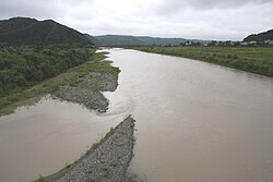
Saru River
River in Hokkaidō, Japan From Wikipedia, the free encyclopedia
River in Hokkaidō, Japan From Wikipedia, the free encyclopedia
Saru River (沙流川, Saru-gawa) is a river in Hokkaidō, Japan.
| Saru River 沙流川 | |
|---|---|
 | |
 | |
| Native name | Saru-gawa (Japanese) |
| Location | |
| Country | Japan |
| State | Hokkaidō |
| Region | Hidaka Subprefecture |
| District | Saru District |
| Municipalities | Biratori, Hidaka |
| Physical characteristics | |
| Source | Mount Kumami |
| • location | Hidaka, Hidaka Subprefecture, Japan |
| • coordinates | 42°58′59″N 142°45′8″E |
| • elevation | 930 m (3,050 ft) |
| Mouth | Pacific Ocean |
• location | Hidaka, Hidaka Subprefecture, Japan |
• coordinates | 42°30′5″N 142°0′31″E |
• elevation | 0 m (0 ft) |
| Length | 104 km (65 mi) |
| Basin size | 1,350 km2 (520 sq mi) |
| [1][2][3] | |
The Saru River rises in the Hidaka Mountains and empties into the Pacific. It is considered sacred in traditional Ainu beliefs.[4]
The Nibutani Dam is situated on the Saru River, at Nibutani village. The construction of this dam was the subject of famous domestic litigation, producing the first ever Japanese legal decision to recognise the Ainu people as an indigenous people. Construction of a second dam, the Biratori Dam is also planned by the Hokkaido Development Board.[5] The 'Cultural Landscape along the Saru River resulting from Ainu Tradition and Modern Settlement' has been designated an Important Cultural Landscape.[6]
Seamless Wikipedia browsing. On steroids.
Every time you click a link to Wikipedia, Wiktionary or Wikiquote in your browser's search results, it will show the modern Wikiwand interface.
Wikiwand extension is a five stars, simple, with minimum permission required to keep your browsing private, safe and transparent.