Loading AI tools

Upazila in Chattogram Division, Bangladesh From Wikipedia, the free encyclopedia
Sandwip (Bengali: সন্দ্বীপ) is an upazila of Chattogram District in Chattogram Division, Bangladesh. It encompasses the islands of Sandwip and Urir Char.[1][2]
Sandwip
সন্দ্বীপ | |
|---|---|
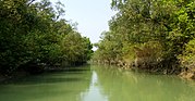
Coast of Sandwip island | |
.svg) | |
| Coordinates: 22°29′N 91°26.5′E | |
| Country | |
| Division | Chittagong |
| District | Chittagong |
| Jatiya Sangsad constituency | Chittagong-3 |
| Upazila | 1984 |
| Headquarters | Sandwip Upazila Complex |
| Government | |
| • Body | Upazila Council |
| • MP | Mahfuzur Rahaman Mita |
| • Chairman | SM Anwar Hossain |
| • Executive officer | Reagan Chakma |
| Area | |
| • Total | 762.42 km2 (294.37 sq mi) |
| Population (2011) | |
| • Total | 278,605 |
| • Density | 370/km2 (950/sq mi) |
| Time zone | UTC+6 (BST) |
| Postal code | 4300, 4301, 4302 |
| Website | sandwip.gov.bd |

Sandwip Thana's status was upgraded to an upazila (sub-district level) in 1984. The construction works of a Bangladesh Navy fleet headquarters at the Sandwip Channel with ship berthing facilities is also going on as part of the Forces Goal 2030.[3] In 2010, the Government of Bangladesh announced a plan to build a dam in Urir Char to reclaim land as it had suffered greatly from Tropical Storm One and the 1991 Bangladesh cyclone among other natural disasters.[4]
Sandwip is located at 22.4833°N 91.4417°E. It has a total area of 762.42 km2.[1]
As of the 2011 Bangladesh census, Sandwip upazila had 56,617 households and a population of 278,605. 71,657 (25.72%) were under 10 years of age. Sandwip had an average literacy rate of 51.47%, compared to the national average of 51.8%, and a sex ratio of 1166 females per 1000 males. 52,982 (19.02%) of the population lived in urban areas.[5][6]
According to the 1991 Bangladesh census, Sandwip had a population of 272,179. Males constituted 49.68% of the population, and females 50.32%. The population aged 18 or over was 122,499. Sandwip had an average literacy rate of 35% (7+ years), against the national average of 32.4%.[7]
Sandwip Upazila is divided into the Sandwip Municipality and 15 union parishads: Amanullah, Azimpur, Bauria, Digghapar, Gachhua, Haramia, Harispur, Kalapania, Magdhara, Maitbhanga, Musapur, Rahmatpur, Santoshpur, Sarikait, and Urirchar. The union parishads are subdivided into 39 mouzas and 34 villages.[8]
Sandwip Municipality is subdivided into 9 wards and 10 mahallas.[8]
| Name | Notes |
|---|---|
| Muhammad Rafiqullah Chowdhury | 1985–1990 |
| Mostafa Kamal Pasha | 1990–1995 |
| Mohammad Shajahan | 2009–2023 |
| Main Uddin Mission | 2023–2024 |
| SM Anwar Hossain | 2024–present |
There are 28 secondary schools in Sandwip Upazila. Some these include:
In total, the Upazila has 149 state primary schools, one junior high school, 4 colleges, 1 girls college, 19 kindergartens and 3 girls high schools. There are 9 dakhil madrasas, 3 alim madrasas, 3 fazil madrasas and four Kamil madrasas. Notable madrasas include the Bashiria Ahmadia Alhaj Abu Bakar Sidiqque Fazil Madrasa, founded in 1902, and the Kashgar Islamia Fazil Madrasa which was founded in 1929. The upazila has a literacy rate of 51.5%.

The upazila is home to 10 orphanages, including one governmental orphanage. It also has 295 mosques which serve the majority Sunni Muslim population that inhabit the sub-district. Some notable mosques include the Shahabanu Mosque, Faqir Shah mosque, the Sandwip Town Jame Mosque, Sandwip Town Bazar Mosque and the Abdul Ghani Chowdhury Mosque. There are 32 haat bazaars and two canals. 26 post offices and 10 banks can also be found here.
Seamless Wikipedia browsing. On steroids.
Every time you click a link to Wikipedia, Wiktionary or Wikiquote in your browser's search results, it will show the modern Wikiwand interface.
Wikiwand extension is a five stars, simple, with minimum permission required to keep your browsing private, safe and transparent.