Rongcheng, Shandong
County-level city in Shandong, People's Republic of China From Wikipedia, the free encyclopedia
County-level city in Shandong, People's Republic of China From Wikipedia, the free encyclopedia
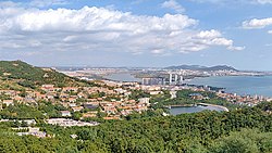
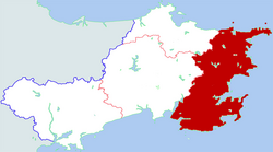
Rongcheng (simplified Chinese: 荣成; traditional Chinese: 榮成; pinyin: Róngchéng) is a county-level city of the prefecture-level city of Weihai, at the eastern extremity of Shandong Province, China, looking out to the Yellow Sea in all directions but the west.
Rongcheng
荣成市 Jungcheng | |
|---|---|
 | |
 Location in Weihai | |
| Coordinates: 37°09′55″N 122°29′12″E | |
| Country | People's Republic of China |
| Province | Shandong |
| Prefecture-level city | Weihai |
| Area | |
| • Total | 1,526 km2 (589 sq mi) |
| Population (2019)[2] | |
| • Total | 738,600 |
| • Density | 480/km2 (1,300/sq mi) |
| Time zone | UTC+8 (China Standard) |
| Area code | 0631 |
According to historical records,[3] the First Emperor of the Qin dynasty had visited Rongcheng twice, building bridges and temples. In 1735, during the Qing dynasty, the Yongzheng Emperor gave Rongcheng its present name.
In June 2011, a mutiny and mass murder broke out on Lurongyu 2682, a fishing trawler registered in Rongcheng. After a month-long killings in the West Pacific, 11 of the 33 crew returned. In July 2013, the Intermediate Court of Wendeng, adjacent to Rongcheng, convicted the 11 men with murder.[4]

There are 10 subdistricts and 12 towns under Rongcheng's administration.
|
|
Rongcheng has a humid continental climate, bordering a humid subtropical climate.
| Climate data for Rongcheng (1991–2020 normals) | |||||||||||||
|---|---|---|---|---|---|---|---|---|---|---|---|---|---|
| Month | Jan | Feb | Mar | Apr | May | Jun | Jul | Aug | Sep | Oct | Nov | Dec | Year |
| Mean daily maximum °C (°F) | 2.7 (36.9) |
4.8 (40.6) |
9.7 (49.5) |
16.0 (60.8) |
21.8 (71.2) |
25.6 (78.1) |
27.9 (82.2) |
28.6 (83.5) |
25.4 (77.7) |
19.7 (67.5) |
12.4 (54.3) |
5.3 (41.5) |
16.7 (62.0) |
| Daily mean °C (°F) | −1.3 (29.7) |
0.3 (32.5) |
4.8 (40.6) |
10.9 (51.6) |
16.7 (62.1) |
21.2 (70.2) |
24.4 (75.9) |
25.0 (77.0) |
21.2 (70.2) |
15.1 (59.2) |
7.9 (46.2) |
1.2 (34.2) |
12.3 (54.1) |
| Mean daily minimum °C (°F) | −4.5 (23.9) |
−3.0 (26.6) |
1.0 (33.8) |
6.8 (44.2) |
12.5 (54.5) |
17.7 (63.9) |
21.7 (71.1) |
22.1 (71.8) |
17.5 (63.5) |
11.0 (51.8) |
4.3 (39.7) |
−2.0 (28.4) |
8.8 (47.8) |
| Average precipitation mm (inches) | 11.8 (0.46) |
15.4 (0.61) |
19.1 (0.75) |
46.1 (1.81) |
63.9 (2.52) |
71.2 (2.80) |
186.6 (7.35) |
171.1 (6.74) |
77.6 (3.06) |
30.2 (1.19) |
33.2 (1.31) |
24.5 (0.96) |
750.7 (29.56) |
| Average precipitation days (≥ 0.1 mm) | 5.5 | 4.2 | 4.2 | 5.7 | 7.4 | 7.7 | 12.3 | 9.8 | 6.9 | 5.6 | 6.2 | 7.4 | 82.9 |
| Average snowy days | 8.1 | 4.8 | 1.8 | 0.1 | 0 | 0 | 0 | 0 | 0 | 0.1 | 2.5 | 8.6 | 26 |
| Average relative humidity (%) | 68 | 66 | 64 | 64 | 70 | 79 | 87 | 84 | 75 | 69 | 70 | 70 | 72 |
| Mean monthly sunshine hours | 175.2 | 181.0 | 226.1 | 235.1 | 250.1 | 216.4 | 169.0 | 201.4 | 220.2 | 217.0 | 170.3 | 159.9 | 2,421.7 |
| Percent possible sunshine | 57 | 59 | 61 | 59 | 57 | 49 | 38 | 48 | 60 | 63 | 56 | 54 | 55 |
| Source: China Meteorological Administration[5][6] | |||||||||||||
| Climate data for Shidao Town, Rongcheng (1991–2020 normals) | |||||||||||||
|---|---|---|---|---|---|---|---|---|---|---|---|---|---|
| Month | Jan | Feb | Mar | Apr | May | Jun | Jul | Aug | Sep | Oct | Nov | Dec | Year |
| Record high °C (°F) | 10.8 (51.4) |
12.7 (54.9) |
18.9 (66.0) |
25.2 (77.4) |
32.0 (89.6) |
32.6 (90.7) |
32.0 (89.6) |
32.2 (90.0) |
31.2 (88.2) |
27.5 (81.5) |
20.6 (69.1) |
15.7 (60.3) |
32.6 (90.7) |
| Mean daily maximum °C (°F) | 3.1 (37.6) |
4.7 (40.5) |
8.8 (47.8) |
14.2 (57.6) |
19.7 (67.5) |
23.2 (73.8) |
26.2 (79.2) |
27.6 (81.7) |
24.9 (76.8) |
19.7 (67.5) |
12.7 (54.9) |
5.9 (42.6) |
15.9 (60.6) |
| Daily mean °C (°F) | −0.4 (31.3) |
1.0 (33.8) |
5.0 (41.0) |
10.5 (50.9) |
15.9 (60.6) |
20.0 (68.0) |
23.5 (74.3) |
24.8 (76.6) |
21.6 (70.9) |
16.0 (60.8) |
9.1 (48.4) |
2.3 (36.1) |
12.4 (54.4) |
| Mean daily minimum °C (°F) | −3.4 (25.9) |
−2.1 (28.2) |
1.9 (35.4) |
7.2 (45.0) |
12.6 (54.7) |
17.2 (63.0) |
21.1 (70.0) |
22.3 (72.1) |
18.5 (65.3) |
12.4 (54.3) |
5.7 (42.3) |
−0.7 (30.7) |
9.4 (48.9) |
| Record low °C (°F) | −12.3 (9.9) |
−12.9 (8.8) |
−5.6 (21.9) |
−0.3 (31.5) |
6.0 (42.8) |
10.6 (51.1) |
16.7 (62.1) |
16.4 (61.5) |
9.3 (48.7) |
0.2 (32.4) |
−5.3 (22.5) |
−8.2 (17.2) |
−12.9 (8.8) |
| Average precipitation mm (inches) | 10.2 (0.40) |
16.2 (0.64) |
21.3 (0.84) |
46.9 (1.85) |
66.9 (2.63) |
76.9 (3.03) |
173.8 (6.84) |
169.8 (6.69) |
79.6 (3.13) |
32.8 (1.29) |
30.4 (1.20) |
16.0 (0.63) |
740.8 (29.17) |
| Average precipitation days (≥ 0.1 mm) | 4.4 | 3.8 | 4.1 | 6.0 | 7.3 | 7.4 | 11.4 | 9.4 | 6.9 | 4.9 | 5.8 | 5.3 | 76.7 |
| Average snowy days | 6.8 | 3.8 | 1.4 | 0.1 | 0 | 0 | 0 | 0 | 0 | 0 | 1.6 | 6.7 | 20.4 |
| Average relative humidity (%) | 65 | 66 | 65 | 67 | 73 | 84 | 89 | 85 | 75 | 67 | 66 | 65 | 72 |
| Mean monthly sunshine hours | 188.0 | 185.8 | 227.7 | 227.1 | 241.7 | 199.5 | 161.0 | 206.4 | 220.4 | 223.0 | 178.5 | 179.7 | 2,438.8 |
| Percent possible sunshine | 61 | 60 | 61 | 57 | 55 | 46 | 36 | 50 | 60 | 65 | 59 | 60 | 56 |
| Source: China Meteorological Administration[7][8] | |||||||||||||
| Climate data for Chengshantou, Rongcheng (1991–2020 normals, extremes 1981–2010) | |||||||||||||
|---|---|---|---|---|---|---|---|---|---|---|---|---|---|
| Month | Jan | Feb | Mar | Apr | May | Jun | Jul | Aug | Sep | Oct | Nov | Dec | Year |
| Record high °C (°F) | 9.9 (49.8) |
16.2 (61.2) |
17.9 (64.2) |
24.3 (75.7) |
29.2 (84.6) |
31.4 (88.5) |
32.0 (89.6) |
31.1 (88.0) |
31.7 (89.1) |
26.1 (79.0) |
20.8 (69.4) |
15.2 (59.4) |
32.0 (89.6) |
| Mean daily maximum °C (°F) | 2.3 (36.1) |
3.3 (37.9) |
7.0 (44.6) |
12.1 (53.8) |
17.6 (63.7) |
21.4 (70.5) |
24.4 (75.9) |
26.3 (79.3) |
24.0 (75.2) |
18.8 (65.8) |
12.0 (53.6) |
5.3 (41.5) |
14.5 (58.2) |
| Daily mean °C (°F) | 0.0 (32.0) |
0.8 (33.4) |
4.1 (39.4) |
8.8 (47.8) |
14.2 (57.6) |
18.4 (65.1) |
21.8 (71.2) |
23.9 (75.0) |
21.8 (71.2) |
16.4 (61.5) |
9.5 (49.1) |
2.9 (37.2) |
11.9 (53.4) |
| Mean daily minimum °C (°F) | −1.9 (28.6) |
−1.2 (29.8) |
1.9 (35.4) |
6.5 (43.7) |
11.4 (52.5) |
15.9 (60.6) |
19.6 (67.3) |
21.9 (71.4) |
19.8 (67.6) |
14.4 (57.9) |
7.3 (45.1) |
0.8 (33.4) |
9.7 (49.4) |
| Record low °C (°F) | −11.4 (11.5) |
−11.7 (10.9) |
−6.6 (20.1) |
−0.4 (31.3) |
4.9 (40.8) |
10.2 (50.4) |
15.0 (59.0) |
17.0 (62.6) |
10.4 (50.7) |
1.3 (34.3) |
−5.0 (23.0) |
−8.7 (16.3) |
−11.7 (10.9) |
| Average precipitation mm (inches) | 9.2 (0.36) |
14.0 (0.55) |
17.9 (0.70) |
38.7 (1.52) |
57.9 (2.28) |
65.4 (2.57) |
171.2 (6.74) |
134.2 (5.28) |
68.6 (2.70) |
30.0 (1.18) |
31.8 (1.25) |
21.3 (0.84) |
660.2 (25.97) |
| Average precipitation days (≥ 0.1 mm) | 5.0 | 4.0 | 4.6 | 6.1 | 8.0 | 8.6 | 12.6 | 9.3 | 6.0 | 5.3 | 6.7 | 7.5 | 83.7 |
| Average snowy days | 8.9 | 4.9 | 1.7 | 0 | 0 | 0 | 0 | 0 | 0 | 0.1 | 2.6 | 8.7 | 26.9 |
| Average relative humidity (%) | 65 | 68 | 71 | 73 | 77 | 88 | 93 | 89 | 75 | 65 | 65 | 65 | 75 |
| Mean monthly sunshine hours | 172.2 | 185.5 | 230.9 | 231.5 | 245.2 | 203.3 | 162.0 | 216.3 | 230.6 | 219.8 | 166.8 | 146.9 | 2,411 |
| Percent possible sunshine | 56 | 60 | 62 | 59 | 56 | 46 | 36 | 52 | 63 | 64 | 55 | 50 | 55 |
| Source: China Meteorological Administration[9][10] | |||||||||||||
Seamless Wikipedia browsing. On steroids.
Every time you click a link to Wikipedia, Wiktionary or Wikiquote in your browser's search results, it will show the modern Wikiwand interface.
Wikiwand extension is a five stars, simple, with minimum permission required to keep your browsing private, safe and transparent.