
Puerto Rico Highway 26
Highway in Puerto Rico / From Wikipedia, the free encyclopedia
Dear Wikiwand AI, let's keep it short by simply answering these key questions:
Can you list the top facts and stats about Puerto Rico Highway 26?
Summarize this article for a 10 year old
SHOW ALL QUESTIONS
Puerto Rico Highway 26 (PR-26),[lower-alpha 1] called the Román Baldorioty de Castro Expressway, is the main highway to the Luis Muñoz Marín International Airport and is connected to PR-66.[2] It was converted to a freeway to minimize the traffic in PR-3 and PR-17, to grant better access to the Airport.[3][4] Several exits exist to provide access to PR-187 (the main route to the Piñones area), PR-37 (Isla Verde) and PR-22 (José de Diego).[5] PR-26 is 15.1 km (9.4 mi) long.[6]
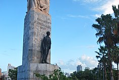 Statue of Román Baldorioty de Castro in PR-26
 PR-26 in Isla Verde
 Puerto Rico Highway 26 in Isla Verde


Quick Facts Highway 26, Route information ...
Highway 26 | ||||
|---|---|---|---|---|
| Ruta 26 | ||||
| Expreso Román Baldorioty de Castro | ||||
| Route information | ||||
| Maintained by Puerto Rico DTPW | ||||
| Length | 15.1 km[1] (9.4 mi) | |||
| Existed | 1982 and completed in 1999[citation needed]–present | |||
| Major junctions | ||||
| West end | ||||
| Major intersections | ||||
| East end | ||||
| Location | ||||
| Country | United States | |||
| Territory | Puerto Rico | |||
| Municipalities | San Juan, Carolina | |||
| Highway system | ||||
| ||||

Close