Portal:Western Australia
Wikipedia portal for content related to Western Australia / From Wikipedia, the free encyclopedia
Portal maintenance status: (October 2020)
|
Introduction
 Western Australia (WA) is a state of Australia occupying the western third of the land area of the Australian continent.[text–source integrity?] It is bounded by the Indian Ocean to the north and west, the Southern Ocean to the south, the Northern Territory to the north-east, and South Australia to the south-east. With a total land area of 2,527,013 square kilometres (975,685 sq mi), Western Australia is Australia's largest state as well as the second-largest subdivision of any country on Earth, surpassed only by the Sakha Republic in eastern Russia. Western Australia has a diverse range of climates, including tropical conditions in the Kimberley, deserts in the interior (including the Great Sandy Desert, Little Sandy Desert, Gibson Desert, and Great Victoria Desert) and a Mediterranean climate on the south-west and southern coastal areas. the state has 2.91 million inhabitants—11 percent of the national total. Over 90 percent of the state's population live in the south-west corner and around 80 percent live in the state capital Perth, leaving the remainder of the state sparsely populated. The Trans-Australian Railway and the Eyre Highway traverse the Nullarbor Plain in the state's south-east, providing the principal connection between Western Australia and the population centres in the eastern states. (Full article...)
|


.jpg)


(Northern
Territory) |
 Good articles - load new batch
 Image 1
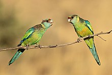 B. z. barnardi near Patchewollock, Victoria
The Australian ringneck (Barnardius zonarius) is a parrot native to Australia. Except for extreme tropical and highland areas, the species has adapted to all conditions. Treatments of genus Barnardius have previously recognised two species, the Port Lincoln parrot (Barnardius zonarius) and the mallee ringneck (Barnardius barnardi), but due to these readily interbreeding at the contact zone they are usually regarded as a single species B. zonarius with subspecific descriptions. Currently, four subspecies are recognised, each with a distinct range.
In Western Australia, the ringneck competes for nesting space with the rainbow lorikeet, an introduced species. To protect the ringneck, culls of the lorikeet are sanctioned by authorities in this region. Overall, though, the ringneck is not a threatened species. (Full article...)- Image 2Tonkin Highway is an 81-kilometre-long (50 mi) north–south highway and partial freeway in Perth, Western Australia, linking Perth Airport and Kewdale with the city's north-eastern and south-eastern suburbs. As of April 2020, the northern terminus is at the interchange with Brand Highway and Great Northern Highway in Muchea, and the southern terminus is at Thomas Road in Oakford. It forms the entire length of State Route 4, and connects to several major roads. Besides Brand Highway and Great Northern Highway, it also connects to Reid Highway, Great Eastern Highway, Leach Highway, Roe Highway, and Albany Highway.
Planning for the route began in the 1950s, but the first segment between Wattle Grove and Cloverdale was not opened until 1980. Over the next five years, the highway was extended north to Great Eastern Highway and south to Albany Highway, and a discontinuous section was constructed north of the Swan River. In 1988 the Redcliffe Bridge linked these sections, and three years later, Reid Highway became the northern terminus. The next major works on the highway, between 2003 and 2005, extended the highway south to Thomas Road. (Full article...) - Image 3

The western rosella (Platycercus icterotis), or moyadong, is a species of parrot endemic to southwestern Australia. The head and underparts are bright red, and the back is mottled black; a yellow patch at the cheek distinguishes it from others of the genus Platycercus. Adults of the species exhibit sexual dimorphism with the females duller overall; juveniles lack the striking colours of mature birds and the characteristic patterning is not as easily distinguished. Their communication call is a softly delivered pink-pink sound, and much of their behaviour is comparatively unobtrusive. Their habitat is in eucalypt forests and woodlands, where they often remain unobserved until they appear to feed on seeds at nearby cleared areas.
Individuals form mating pairs and generally remain in one locality, although they will venture out to join small groups at plentiful sources of food. The western rosella is predominantly herbivorous, its diet consisting mostly of seeds of grasses and other plants, although nectar and insect larvae are sometimes eaten. The damage attributed to the species at introduced fruit and grain crops saw them declared as a pest and permitted by the state to be killed or captured. They are more placid and sociable than rosellas of other Australian regions from which they are geographically isolated and have become internationally popular as an aviary bird. Their history in aviculture begins with two 1830 lithographs of live specimens in England by Edward Lear. Successful breeding in captivity began there during the early 20th century. (Full article...) - Image 4
 Mitchell in 2012
Lauren Stephanie Mitchell OAM (born 23 July 1991) is an Australian former artistic gymnast. She is the 2010 World champion on the floor exercise and the 2009 World Championships silver medalist on the balance beam and floor exercise. Mitchell is only the second Australian female gymnast to win a medal at the World Championships, and she is the first to win a gold medal. She is the 2010 Commonwealth Games champion in the all-around, uneven bars, and balance beam, and with the Australian team, and she is the 2008 World Cup Final balance beam champion. She also represented Australia at the 2008 and 2012 Olympic Games.
In her first year of senior competition, Mitchell qualified for the balance beam event final at the 2007 World Championships. Then at the 2008 Summer Olympics, she helped the Australian team place sixth, their highest finish ever. She then became the first Australian gymnast to win more than one medal at the same World Championships when she won two silver medals in 2009. The next year, she tied the record for the most gold medals won by a female gymnast at a single Commonwealth Games and became Australia's first female World champion in gymnastics. At her second Olympic Games in 2012, she qualified for the floor exercise final and finished fifth. She won two more Commonwealth medals in 2014, silver with the team and on the floor exercise. Mitchell retired from gymnastics in 2016 as Australia's most decorated gymnast. (Full article...) - Image 5

The 2010 Gascoyne River flood was regarded as the most severe flood to take place along the Gascoyne River in Western Australia on record. Triggered by record-breaking rainfall, amounting to over 6,000 percent of the monthly mean, 313.6 mm (12.35 in) and 5 mm (0.20 in) respectively, in just four days, the floods caused widespread damage in the region. By 17 December, the river began to rise in response to the heavy rains, eventually exceeding its banks within two days. Water levels reached record values at three stations along the river, cresting at 15.53 m (51.0 ft) near Fishy Pool. Evacuation orders were issued for several towns affected by rising waters. The most substantial impact was felt in Carnarvon where entire homes were washed away. Following the disaster, emergency supplies and funds were distributed to affected residents to aid them in restoring their livelihoods. Though no people died in the event, an estimated two thousand head of cattle perished and damage was estimated at A$100 million. (Full article...) - Image 6John Biase D'Orazio (5 September 1955 – 11 April 2011) was an Australian politician who served as the member for Ballajura in the Western Australian Legislative Assembly from 10 February 2001 to 6 September 2008. He was a minister in the governments of Geoff Gallop and Alan Carpenter, and a member of the Labor Party until 29 August 2006, when he resigned following several controversies. Born to Italian immigrants, D'Orazio grew up on a market garden in the Perth suburb of Bayswater. He studied pharmacy at the Western Australian Institute of Technology, later opening his own pharmacy business. In 1981, he was elected to the City of Bayswater council, and in 1984, he became the mayor of Bayswater, in which position he served until 2001.
At the 2001 Western Australian state election, D'Orazio was elected to the seat of Ballajura, beating the Liberal incumbent Rhonda Parker. Following the 2005 state election, he was promoted to cabinet by Premier Geoff Gallop, becoming the minister for justice and minister for small business. In February 2006, after Alan Carpenter became premier, D'Orazio was appointed as the minister for police and emergency services, minister for justice, and minister for community safety. (Full article...) - Image 7
 View of King William Street south from the Bayswater station shared path in January 2024
Bayswater is a suburb 6 kilometres (4 mi) north-east of the central business district (CBD) of Perth, the capital of Western Australia. It is just north of the Swan River, within the City of Bayswater local government area. It is predominantly a low-density residential suburb consisting of single-family detached homes. However, there are several clusters of commercial buildings, most notably in the suburb's town centre, around the intersection of Whatley Crescent and King William Street and a light industrial area in the suburb's east.
Prior to European settlement, the Mooro group of the Whadjuk Noongar people inhabited the area. In 1830, the year after the European settlement of the Swan River Colony, land along the river was divided between the colonists, who moved in soon after. Most either died or left in the months following, leaving the area undeveloped for most of the 19th century. In 1881, the Fremantle–Guildford railway line was built, triggering the founding of the Bayswater Estate, the first development in the area, and in 1897, the Bayswater Road Board was founded, giving Bayswater its own local government. At first, development consisted of nurseries, market gardens and dairies, but as time went on, Bayswater became more and more suburban. Today, Bayswater is fully suburbanised, with the subdividing of older lots being commonplace. Plans for apartments around Bayswater and Meltham railway stations are a contentious issue. (Full article...) - Image 8

The West Coast Eagles are an Australian rules football team based in Perth, Western Australia. Their 2019 season was their 33rd season in the Australian Football League (AFL), their sixth season under coach Adam Simpson, and their fifth and final season with Shannon Hurn as captain. Having won the 2018 AFL Grand Final, expectations were that West Coast would finish in the top four on the ladder. They won only three of their first six games, losing by greater than 40 points to the Brisbane Lions, Port Adelaide and Geelong, placing the Eagles 12th on the ladder at the end of round six. They then won 12 of their next 14 games, the losses being to Sydney by 45 points and to Collingwood by 1 point. By the end of round 21, West Coast had been in the top four since round 14, and were aiming to finish in the top two. They then had a disappointing six-point loss to Richmond, and a shock 38-point loss to Hawthorn at home, to finish the season fifth on the ladder. This meant West Coast missed out on the double chance that top four teams get in the AFL finals, significantly lowering their chances of winning the Grand Final. In the 2019 AFL finals series, they faced Essendon in an elimination final, beating them by 55 points, before losing to Geelong in a semi-final by 20 points, ending West Coast's season.
Notable events include Daniel Venables suffering a career-ending concussion in round nine, Nic Naitanui returning from injury in round 15, having been out since round 17, 2018, and Willie Rioli being provisionally suspended before the semi-final after tampering with a drug test. Jack Darling, who kicked 59 goals, was the club's leading goal-scorer for the third time in his career. Darling, Hurn, Jeremy McGovern and Elliot Yeo were selected for the 2020 All-Australian team. Liam Ryan won Mark of the Year for a mark he took in round nine against Melbourne. Luke Shuey was West Coast's best and fairest player, winning the John Worsfold Medal. West Coast fielded a reserves team in the West Australian Football League for the first time in 2019. (Full article...) - Image 9Susie Bootja Bootja Napaltjarri (also referred to as Susie Bootja Bootja Napangardi, Napangarti, or Napangati) (c. 1935 – 16 January 2003) was an Indigenous artist from Australia's Western Desert region. Born south-west of Balgo, Western Australia, in the 1950s Susie Bootja Bootja married artist Mick Gill Tjakamarra, with whom she had a son, Matthew Gill Tjupurrula (also an artist).
Susie Bootja Bootja's painting career followed the establishment of Warlayirti Artists, an Indigenous art centre at Balgo. One of the area's strongest artists, her work was characterised by an expressive style, and has been acquired by major Australian galleries, including the Art Gallery of New South Wales and National Gallery of Victoria. She died in 2003. (Full article...) - Image 10
 Map of Western Australia with Great Northern Highway highlighted in red
Great Northern Highway is an Australian highway that links Western Australia's capital city Perth with its northernmost port, Wyndham. With a length of almost 3,200 kilometres (2,000 mi), it is the longest highway in Australia, with the majority included as part of the Perth Darwin National Highway. The highway, which travels through remote areas of the state, is constructed as a sealed, predominantly two-lane single carriageway, but with some single-lane bridges in the Kimberley. Economically, it provides vital access through the Wheatbelt and Mid West to the resource-rich regions of the Pilbara and Kimberley. In these areas, the key industries of mining, agriculture and pastoral stations, and tourism are all dependent on the highway.
In Perth, the highway begins in Midland near Great Eastern Highway, and further north intersects the Reid and Roe highways, which together form Perth's ring road. There are also three rural highways that spur off Great Northern Highway. Brand Highway and North West Coastal Highway provide an alternative coastal route between Muchea and Port Hedland, while Victoria Highway carries the National Highway route and interstate traffic into the Northern Territory. Various road routes are allocated to sections of Great Northern Highway, including the Highway 1 routes National Route 1 and National Highway 1, as well as National Highway 95. (Full article...) - Image 11
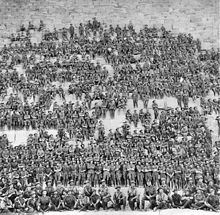 Soldiers of 11th Battalion posing on the Great Pyramid of Giza on 10 January 1915, prior to the landing at Gallipoli
The 11th Battalion was an Australian Army battalion that was among the first infantry units raised during World War I for the First Australian Imperial Force. It was the first battalion recruited in Western Australia, and following a brief training period in Perth, the battalion sailed to Egypt where it undertook four months of intensive training. In April 1915 it took part in the invasion of the Gallipoli Peninsula, landing at Anzac Cove. In August 1915 the battalion was in action in the Battle of Lone Pine. Following the withdrawal from Gallipoli, the battalion returned to Egypt where it was split to help form the 51st Battalion. In March 1916, the battalion was deployed to the Western Front in France and Belgium where it took part in trench warfare until the end of the war in November 1918.
The battalion was disbanded in 1919, but since 1921 has been re-activated and merged several times as a reserve unit, initially as the 11th Battalion (City of Perth Regiment), which fought a brief campaign against the Japanese on New Britain during World War II. Other units that have maintained the traditions of the original 11th Battalion include the 11th/44th Battalion (City of Perth Regiment), 'A' (City of Perth) Company, 1st Battalion, Royal Western Australia Regiment and the current 11th/28th Battalion, Royal Western Australia Regiment. (Full article...) - Image 12
 Southbound view in December 2021
Clarkson railway station is a suburban rail station in Clarkson, a suburb of Perth, Western Australia. It is on the Yanchep line, which is part of the Transperth network. Located in the median of the Mitchell Freeway, the station consists of an island platform connected to the west by a pedestrian footbridge. A six-stand bus interchange and two carparks are located near the entrance.
Planning for an extension of the Yanchep line (then known as the Joondalup line) north of Currambine station was underway by 1995. The government committed to an extension to Clarkson the following year, and a plan detailing the extension was released in 2000. The first contract for the project, a A$14 million earthworks contract, was awarded to Brierty Contractors in March 2001. In April 2002, Barclay Mowlem and Alstom were awarded a contract worth $17 million to design and build the extension's rail infrastructure, and in November 2002, a $8.7 million contract was awarded to Transfield for the construction of the station. The station opened on 4 October 2004, with five new Transperth B-series trains entering service that day. The following day, bus services in the area were realigned to feed into Clarkson station. On 3 September 2013, there was a minor train crash at Clarkson station. On 21 September 2014, an extension of the Joondalup line 7.5 kilometres (4.7 mi) north to Butler station opened. (Full article...) - Image 13The West Coast Eagles are an Australian rules football team based in Perth, Western Australia. Their 2020 season was their 34th season in the Australian Football League (AFL), their seventh season under premiership coach Adam Simpson, and the first season with Luke Shuey as captain. The West Coast Eagles finished the season with 12 wins and 5 losses, placing them fifth on the ladder, qualifying for the 2020 AFL finals series, in which they were eliminated in the first round by eighth-placed Collingwood. The COVID-19 pandemic had a significant impact on their season, with the team forced to hub in Queensland for much of the season due to restrictions on travelling to Western Australia from other states.
Nic Naitanui was West Coast's best and fairest player, winning the John Worsfold Medal. Previously his highest place for the medal was fifth, in 2010. Josh Kennedy, who kicked 34 goals was the club's leading goal-scorer for the seventh time in his career. Naitanui, Liam Ryan and Brad Sheppard were selected for the 2020 All-Australian team. (Full article...) - Image 14

Henry Daglish (18 November 1866 – 16 August 1920) was an Australian politician who was the sixth premier of Western Australia and the first from the Labor Party, serving from 10 August 1904 to 25 August 1905. Daglish was born in Ballarat, Victoria, and studied at the University of Melbourne. In 1882, he worked as a mechanical engineer but soon switched to working in the Victorian public service. He first stood for election in 1896 but failed to win the Victorian Legislative Assembly seat of Melbourne South. He then moved to Subiaco, Western Australia, where he found work as a chief clerk in the Western Australian Police Department. In 1900, Daglish was elected to the Subiaco Municipal Council and in April the following year, he was elected to the Western Australian Legislative Assembly as the member for the newly created seat of Subiaco, becoming one of six Labor members in the Western Australian Legislative Assembly. The party elected him as its whip, and he resigned from the Subiaco council on 1 May 1901. On 1 December 1902, Daglish was sworn in as mayor of Subiaco, having been elected the previous month.
In the 1904 state election, Labor won 22 of the Legislative Assembly's 50 seats, making it the party with the most seats. On 8 July 1904, the Labor Party caucus elected Daglish as the party's leader, and on 10 August, he successfully moved a motion of no confidence in the government of Walter James, who resigned as premier. Governor Frederick Bedford then swore in Daglish as premier of Western Australia, colonial treasurer and minister for education. His keynote speech on 23 August was poorly received; militant Labor supporters saw him as giving up on Labor policies. In parliament, Daglish struggled to achieve anything due to a hostile Legislative Council; his one major success was the passing of a new Public Service Act. In June 1905, a cabinet reshuffle decreased Daglish's popularity within the Labor Party but he defeated a motion of no confidence at a caucus meeting later that month. Daglish resigned as premier on 22 August 1905 when his plan to buy the Midland Railway Company for £1.5 million (equivalent to AU$126,500,000 in 2022) failed to pass through parliament. Hector Rason succeeded him as premier on 25 August. (Full article...) - Image 15
 Location of the electoral district of Perth (dark green) in the Perth metropolitan area
The electoral district of Perth is a Legislative Assembly electorate in the state of Western Australia. Perth is named for the capital city of Western Australia whose central business district falls within its borders. It is one of the oldest electorates in Western Australia, with its first member having been elected in the inaugural 1890 elections of the Legislative Assembly.
Perth has traditionally been a safe Labor seat, but was briefly held by Liberal Eleni Evangel between 2013 and 2017. Perth is currently held by Labor MLA John Carey. (Full article...)


Did you know (auto-generated)

- ... that Bill Dunn, an Indigenous Australian pastoralist approaching retirement, sold his station at half-price to the Jigalong community despite receiving full-price offers from non-Indigenous people?
- ... that Nick Goiran, a member of the Western Australian Legislative Council, proposed 357 amendments to a voluntary assisted dying bill?
- ... that Western Australia was the second Australian state to legalise voluntary assisted dying?
- ... that the search for a lost radioactive capsule along a 1,400-kilometre (870 mi) stretch of road in Western Australia was likened to looking for a needle in a haystack?
- ... that politician John D'Orazio helped to secure a three-year trial of daylight saving time in Western Australia?
Categories

More portals
More did you know...

- ...that when the 1987 America's Cup was raced off Fremantle, Western Australia it was the first time for 132 years that the regatta had not been hosted by the New York Yacht Club?
- ...that the original Victoria Dam, constructed in 1891, was the first dam in Western Australia, and it stood for almost 100 years before being replaced with the current dam?
- ...that Anglican bishop Kay Goldsworthy was consecrated as the first woman bishop of any Australian church on 22 May 2008?
Related WikiProjects

Things you can do
Here are some tasks you can do to help with WikiProject Western Australia:
Associated Wikimedia
The following Wikimedia Foundation sister projects provide more on this subject:
-
 Commons
Free media repository -
 Wikibooks
Free textbooks and manuals -
 Wikidata
Free knowledge base -
 Wikinews
Free-content news -
 Wikiquote
Collection of quotations -
 Wikisource
Free-content library -
 Wikispecies
Directory of species -
 Wikiversity
Free learning tools -
 Wikivoyage
Free travel guide -
 Wiktionary
Dictionary and thesaurus


