Portal:U.S. roads
Wikipedia portal for content related to U.S. roads / From Wikipedia, the free encyclopedia
Portal maintenance status: (June 2018)
|
The U.S. Roads Portal
The highway system of the United States is a network of interconnected state, U.S., and Interstate highways. Each of the fifty states, the District of Columbia, Puerto Rico, American Samoa, Guam, the Northern Mariana Islands, and the U.S. Virgin Islands own and maintain a part of this vast system, including U.S. and Interstate highways, which are not owned or maintained at the federal level.


Interstate Highways have the highest speed limits and the highest traffic numbers. Interstates are numbered in a grid: even-numbered routes for east–west routes (with the lowest numbers along Mexico and the Gulf of Mexico), and odd-numbered routes are north–south routes (with the lowest numbers along the Pacific Ocean). Three-digit Interstates are, generally, either beltways or spurs of their parent Interstates (for example, Interstate 510 is a spur into the city of New Orleans, Louisiana, and is connected to Interstate 10).


U.S. Numbered Highways are the original interstate highways, dating back to 1926. U.S. Highways are also numbered in a grid: even numbered for east–west routes (with the lowest numbers along Canada) and odd numbered for north–south routes (with the lowest numbers along the Atlantic Ocean). Three-digit highways, also known as "child routes," are branches off their main one- or two-digit "parents" (for example, U.S. Route 202 is a branch of U.S. Route 2). However, US 101, rather than a "child" of US 1, is considered a "mainline" U.S. Route.


State highways are the next level in the hierarchy. Each state and territory has its own system for numbering highways, some more systematic than others. Each state also has its own design for its highway markers; the number in a circle is the default sign, but many choose a different design connected to the state, such as an outline of the state with the number inside. Many states also operate a system of county highways.


Scenic byways can be designated over any classification of road in the United States. There are the National Scenic Byways, National Forest Scenic Byways and Bureau of Land Management Back Country Byways at the national level. Most states have their own system for designating byways, some more systematic than others. Native American tribes may designate byways as well.
 Featured articles - load new batch
 Image 1State Route 520 (SR 520) is a state highway and freeway in the Seattle metropolitan area, part of the U.S. state of Washington. It runs 13 miles (21 km) from Seattle in the west to Redmond in the east. The freeway connects Seattle to the Eastside region of King County via the Evergreen Point Floating Bridge on Lake Washington. SR 520 intersects several state highways, including Interstate 5 (I-5) in Seattle, I-405 in Bellevue, and SR 202 in Redmond.
The original floating bridge was opened in 1963 as a replacement for the cross-lake ferry system that had operated since the late 19th century. In 1964, SR 520 was designated as a freeway connecting I-5 to I-405. An extension to Redmond was proposed later in the decade. In the 1970s and 1980s, sections of the freeway between Bellevue and Redmond were opened to traffic, replacing the temporary designation of SR 920. (Full article...)- Image 2State Route 522 (SR 522) is a state highway in the U.S. state of Washington that serves the Seattle metropolitan area. Approximately 25 miles (40 km) long, it connects the city of Seattle to the northeastern suburbs of Kenmore, Bothell, Woodinville, and Monroe. Its western half is primarily an arterial street, named Lake City Way and Bothell Way, that follows the northern shore of Lake Washington; the eastern half is a grade-separated freeway that runs between Woodinville and Monroe. SR 522 connects several of the metropolitan area's major highways, including Interstate 5 (I-5), I-405, SR 9, and U.S. Route 2 (US 2).
The present-day route of SR 522 was built in stages between 1907 and 1965, beginning with the Red Brick Road from Seattle to Bothell, then part of the Pacific Highway and later US 99. The road later became a branch of Primary State Highway 2 (PSH 2) in 1937, and was extended east to Redmond and North Bend. A branch of the Stevens Pass Highway was built to connect PSH 2 in Bothell and Monroe in 1965, and was incorporated into SR 202 after it was designated in 1964. The Bothell–Monroe highway was re-designated as part of SR 522 in 1970, leaving SR 202 on the Bothell–North Bend highway. (Full article...) - Image 3M-553 is a north–south state trunkline highway in the Upper Peninsula (UP) of the US state of Michigan. It connects M-35 near Gwinn with the Marquette Bypass, an expressway carrying US Highway 41 (US 41) and M-28 in Marquette. M-553 connects Marquette with Marquette Sawyer Regional Airport at the unincorporated community of K.I. Sawyer, the former site of a US Air Force base, in the Sands Plains area of Marquette County. The intersection with County Road 480 (CR 480) in Sands Township, known locally as the Crossroads, is the site of several businesses. North of this location, M-553 runs through some hilly terrain around a local ski hill.
The trunkline was originally County Road 553 (CR 553) in Marquette County. CR 553 dates back to the 1930s, was fully paved in the 1940s, and a segment of the roadway was relocated in the 1950s. During the early 1990s, the City of Marquette extended one of their streets, McClellan Avenue, southward to connect to CR 553. The county road was transferred from the Marquette County Road Commission (MCRC) to the jurisdiction of the Michigan Department of Transportation (MDOT) on October 1, 1998. MDOT assigned most of the former county road the M-553 designation after the transfer was complete. One section that was less than a mile (about 1.4 km) was given the M-554 designation. This related trunkline was unsigned by the state with only city street signs to indicate its existence. In 2005, control of various roadways was exchanged between the City of Marquette and MDOT, and M-553 was extended through the city. At the same time, M-554 was turned over to the city's jurisdiction. (Full article...) - Image 4Interstate 675 (I-675) is an auxiliary Interstate Highway in the US state of Michigan. The freeway is a 7.7-mile-long (12.4 km) loop route through downtown Saginaw, as I-75 passes on the east side of the city. I-675 is also a state trunkline highway that provided a bypass of the former drawbridge carrying I-75 and US Highway 23 (US 23) across the Saginaw River. Construction of I-675 started in 1969 and the freeway opened in 1971. Since then, sections near downtown were reconstructed between 2009 and 2011 to update one of the freeway's interchanges and rebuild the bridge over the Saginaw River. (Full article...)
- Image 5New York State Route 74 (NY 74) and Vermont Route 74 (VT 74) are state highways in the northeastern United States, connected by one of the last remaining cable ferries in North America. Together they extend for 34 miles (55 km) through Essex County, New York, and Addison County, Vermont. NY 74 begins at exit 28 off Interstate 87 (I-87) in the hamlet of Severance in the Adirondack Mountains region of the northern part of New York State. It extends 20.44 miles (32.89 km) to the western shore of Lake Champlain in Ticonderoga. There, the seasonal Fort Ticonderoga–Larrabees Point Ferry carries cars across the state border into Vermont, where VT 74 starts at the lake's eastern shore and terminates 13.26 miles (21.34 km) later at a junction with VT 30 in the town of Cornwall.
The ferry connecting the two highways, predating both NY 74 and VT 74, began operation in 1759 on an informal basis. The ferry operation was formalized at the close of the 18th century and upgraded to a cable system in 1946. (Full article...) - Image 6

View of the route, 1920
The Ridge Route, officially the Castaic–Tejon Route and colloquially known as the Grapevine, was a two-lane highway between Los Angeles County and Kern County, California. Opened in 1915 and paved with concrete between 1917 and 1921, the road was the first paved highway directly linking the Los Angeles Basin with the San Joaquin Valley (southern Central Valley) over the Tejon Pass and the rugged Sierra Pelona Mountains ridge south of Gorman. Much of the old road runs through the Angeles National Forest, and passes many historical landmarks, including the National Forest Inn, Reservoir Summit, Kelly's Half Way Inn, Tumble Inn, and Sandberg's Summit Hotel. North of the forest, the Ridge Route passed through Deadman's Curve before ending at Grapevine.
The road was bypassed by the three-lane Ridge Route Alternate, then U.S. Route 99 (US 99), to handle increased traffic and remove curves; the Alternate in Los Angeles County was completed in 1933, and Kern County line to Grapevine in 1936. The four-lane US 99 was completed in 1953 and replaced by an eight-lane freeway, Interstate 5 (I-5) in 1960-70. The portion of the road in the Angeles National Forest was added to the National Register of Historic Places in 1997, by the efforts of Harrison Scott. Much of the road has been closed by the U.S. Forest Service; other remnants are used by local traffic. (Full article...) - Image 7Interstate 94 (I-94) is a part of the Interstate Highway System that runs from Billings, Montana, to the Lower Peninsula of the US state of Michigan. In Michigan, it is a state trunkline highway that enters the state south of New Buffalo and runs eastward through several metropolitan areas in the southern section of the state. The highway serves Benton Harbor–St. Joseph near Lake Michigan before turning inland toward Kalamazoo and Battle Creek on the west side of the peninsula. Heading farther east, I-94 passes through rural areas in the middle of the southern Lower Peninsula, crossing I-69 in the process. I-94 then runs through Jackson, Ann Arbor, and portions of Metro Detroit, connecting Michigan's largest city to its main airport. Past the east side of Detroit, the Interstate angles northeasterly through farmlands in The Thumb to Port Huron, where the designation terminates on the Blue Water Bridge at the Canada–United States border.
The first segment of what later became I-94 within the state, the Willow Run Expressway, was built near Ypsilanti and Belleville in 1941, with an easterly extension to Detroit in 1945. This expressway was initially numbered M-112. In the mid-1950s, state and federal officials planned an Interstate to replace the original route of US Highway 12 (US 12). By 1960, the length of I-94 was completed from Detroit to New Buffalo. Two years later, the US 12 designation was dropped from the freeway. Subsequent extensions in the 1960s completed most of the rest of the route, including the remaining sections between Detroit and Port Huron which superseded the routing of US 25. The last segment opened to the public in 1972 when Indiana completed its connection across the state line. Since completion, I-94 has remained relatively unchanged; a few interchanges have been rebuilt, a second span was constructed for the Blue Water Bridge, and, in 1987, a plane crashed on the freeway during takeoff from the airport in Detroit. The routing of I-94 is notable for containing the first full freeway-to-freeway interchange in the United States, connecting to the Lodge Freeway (M-10), and for comprising the first complete border-to-border toll-free freeway in a state in the United States. The highway has one auxiliary route, I-194, which serves downtown Battle Creek, and eight business routes. Various segments have been dedicated to multiple people and places. (Full article...) - Image 8
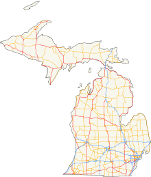
The State Trunkline Highway System consists of all the state highways in Michigan, including those designated as Interstate, United States Numbered (US Highways), or State Trunkline highways. In their abbreviated format, these classifications are applied to highway numbers with an I-, US, or M- prefix, respectively. The system is maintained by the Michigan Department of Transportation (MDOT) and comprises 9,669 miles (15,561 km) of trunklines in all 83 counties of the state on both the Upper and Lower peninsulas (UP, LP), which are linked by the Mackinac Bridge. Components of the system range in scale from 10-lane urban freeways with local-express lanes to two-lane rural undivided highways to a non-motorized highway on Mackinac Island where cars are forbidden. The longest highway is nearly 400 miles (640 km) long, while the shortest is about three-quarters of a mile (about 1.2 km). Some roads are unsigned highways, lacking signage to indicate their maintenance by MDOT; these may be remnants of highways that are still under state control whose designations were decommissioned or roadway segments left over from realignment projects.
Predecessors to today's modern highways include the foot trails used by Native Americans in the time before European settlement. Shortly after the creation of the Michigan Territory in 1805, the new government established the first road districts. The federal government aided in the construction of roads to connect population centers in the territory. At the time, road construction was under the control of the township and county governments. The state government was briefly involved in roads until prohibited by a new constitution in 1850. Private companies constructed plank roads and charged tolls. Local township roads were financed and constructed through a statute labor system that required landowners to make improvements in lieu of taxes. Countywide coordination of road planning, construction and maintenance was enacted in the late 19th century. (Full article...) - Image 9State Route 76 (SR 76) is a state highway 52.63 miles (84.70 km) long in the U.S. state of California. It is a much used east–west route in the North County region of San Diego County that begins in Oceanside near Interstate 5 (I-5) and continues east. The highway is a major route through the region, passing through the community of Bonsall and providing access to Fallbrook. East of the junction with I-15, SR 76 goes through Pala and Pauma Valley before terminating at SR 79.
A route along the corridor has existed since the early 20th century, as has the bridge over the San Luis Rey River near Bonsall. The route was added to the state highway system in 1933, and was officially designated by the California State Legislature as SR 76 in the 1964 state highway renumbering. The section of the highway through Oceanside and Bonsall is mostly a four-lane expressway; east of I-15, the roadway is mostly a two-lane highway. Originally, the entire highway was two lanes wide; west of Bonsall, the route was widened in stages, after decades of funding shortages, planning, and litigation. The California Department of Transportation (Caltrans) maintained plans to expand the entire length of the highway west of I-15 to an expressway, and as of May 2017, construction between Bonsall and I-15 was complete. (Full article...) - Image 10H-58 is a county-designated highway in the US state of Michigan that runs east–west for approximately 69 miles (111 km) between the communities of Munising and Deer Park in the Upper Peninsula. The western section is routed through Pictured Rocks National Lakeshore, along the southern shore of Lake Superior, and the adjacent Lake Superior State Forest in Alger County while connecting Munising to the communities of Van Meer and Melstrand. At Grand Marais, H-58 exits the national lakeshore area and runs through town. The segment running east of Grand Marais to Deer Park in Luce County is a gravel road that connects to H-37 in Muskallonge Lake State Park.
A roadway was present along parts of today's H-58 by the late 1920s; initially, this county road was gravel or earth between Munising and Kingston Corners and connected with other roads to Grand Marais. In the 1930s, another segment was built to connect to Deer Park and to fill in the gap between Kingston Corners and Grand Marais. The southwestern segment between Munising and Van Meer formed part of M-94 from 1929 until it was transferred back to county control in the early 1960s. (Full article...) - Image 11Interstate 275 (I-275) is an auxiliary Interstate Highway in the US state of Michigan that acts as a western bypass of the Detroit metropolitan area. The Michigan Department of Transportation (MDOT) maintains the highway as part of the larger State Trunkline Highway System. The freeway runs through the western suburbs near Detroit Metropolitan Wayne County Airport, and crosses several rivers and rail lines in the area. The southern terminus is the interchange with I-75 near Newport, northeast of Monroe. MDOT considers the Interstate to run to an interchange with I-96, I-696 and M-5 on the Farmington Hills–Novi city line, running concurrently with I-96 for about five miles (8.0 km). This gives a total length of about 35.03 miles (56.38 km), which is backed up by official signage. According to the Federal Highway Administration (FHWA), the length is 29.97 miles (48.23 km) because that agency considers I-275 to end at the junction with I-96 and M-14 along the boundary between Livonia and Plymouth Township. All other map makers, like the American Automobile Association, Rand McNally and Google Maps follow MDOT's practice.
A highway roughly parallel to the modern I-275 was included in early planning maps for the Interstate Highway System in the 1950s. As plans developed through the 1960s and into the early 1970s, the freeway was to run from I-75 near Newport north to Novi and connect back to I-75 near Davisburg. Some plans in the 1970s had the northern Novi–Davisburg section numbered as a state highway M-275. The southern half of I-275 was built in segments that were completed in January 1977. Later that month, the state canceled the northern section because of local opposition. A later attempt to revive the proposal failed in 1979. Additional plans to complete M-275 through Oakland County were kept on the drawing boards through the 1980s, but failed to materialize. M-5 (Haggerty Connector) opened along part of the former I-275/M-275 right-of-way between 1994 and 2000. (Full article...) - Image 12Interstate 805 (I-805) is a major north–south auxiliary Interstate Highway in Southern California. It is a bypass auxiliary route of I-5, running roughly through the center of the Greater San Diego region from San Ysidro (part of the city of San Diego) near the Mexico–U.S. border to near Del Mar. The southern terminus of I-805 at I-5 in San Ysidro is less than 1 mi (1.6 km) north of the Mexican border. I-805 then traverses the cities of Chula Vista and National City before reentering San Diego. The freeway passes through the San Diego neighborhoods of North Park, Mission Valley, Clairemont, and University City before terminating at I-5 in the Sorrento Valley neighborhood near the Del Mar city limit.
Planning for I-805 began in 1956, and the route was officially designated in 1959 before it was renumbered in the 1964 state highway renumbering. Starting in 1967, the freeway was built in phases, with the northern part of the freeway finished before the southern part. I-805 was completed and open to traffic in 1975. Named the Jacob Dekema Freeway after the longtime head of the regional division of the California Department of Transportation (Caltrans), I-805 has been frequently cited for its complex engineering and architecture, including near I-8 on the Mission Valley Viaduct. Since then, several construction projects have taken place, including the construction of carpool lanes. (Full article...) - Image 13State Route 57 (SR 57), also known as the Orange Freeway for most of its length, is a north–south state highway in the Greater Los Angeles Area of the U.S. state of California. It connects the interchange of Interstate 5 (I-5) and SR 22 near downtown Orange, locally known as the Orange Crush, to the Glendora Curve interchange with I-210 and SR 210 in Glendora. The highway provides a route across several spurs of the Peninsular Ranges, linking the Los Angeles Basin with the Pomona Valley and San Gabriel Valley.
A predecessor to this road ran through Brea Canyon by the early 20th century and was added to the state highway system. The freeway was built in stages during the 1950s, one of which included the Brea Canyon Freeway; SR 57 was designated as part of the 1964 state highway renumbering. The final portion of the present-day Orange Freeway was not completed until the mid-1970s. The latest piece of SR 57 to be added was formerly part of I-210, after SR 210 was legislatively extended to San Bernardino in 1998. An unconstructed extension from Santa Ana south to Huntington Beach remains in the legal definition of SR 57, and has been studied as a toll road above the Santa Ana River. (Full article...) - Image 14Interstate 40 (I-40) is part of the Interstate Highway System that runs 2,556.61 miles (4,114.46 km) from Barstow, California, to Wilmington, North Carolina. The highway crosses Tennessee from west to east, from the Mississippi River at the Arkansas border to the Blue Ridge Mountains at the North Carolina border. At 455.28 miles (732.70 km), the Tennessee segment of I-40 is the longest of the eight states through which it passes and the state's longest Interstate Highway.
I-40 passes through Tennessee's three largest cities—Memphis, Nashville, and Knoxville—and serves the Great Smoky Mountains National Park, the most-visited national park in the United States. It crosses all of Tennessee's physiographic regions and Grand Divisions—the Mississippi embayment and Gulf Coastal Plain in West Tennessee, the Highland Rim and Nashville Basin in Middle Tennessee, and the Cumberland Plateau, Cumberland Mountains, Ridge-and-Valley Appalachians, and Blue Ridge Mountains in East Tennessee. Landscapes on the route vary from flat, level plains and swamplands in the west to irregular rolling hills, cavernous limestone bluffs, and deep river gorges in the central part of the state, to plateau tablelands, broad river valleys, narrow mountain passes, and mountain peaks in the east. (Full article...) - Image 15
Interchange with I-55 in Bolingbrook, formerly the southern terminus of I-355
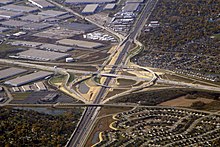
Interstate 355 (I-355), also known as the Veterans Memorial Tollway, is an Interstate Highway and tollway in the western and southwest suburbs of Chicago in the U.S. state of Illinois. Like most other toll roads in the northeastern portion of the state, I-355 is maintained by the Illinois State Toll Highway Authority (ISTHA). I-355 runs from I-80 in New Lenox north to I-290 in Itasca, a distance of 32.5 miles (52.3 km). With the exception of a four-mile (6.4 km) expansion in 2009, from U.S. Route 34 (US 34, Ogden Avenue) to 75th Street, the highway is six lanes wide for its entire length.
The tollway authority opened I-355 as the North–South Tollway in 1989 to ease congestion on Illinois Route 53 (IL 53), a parallel two-lane state highway in central DuPage County. Initially, I-355 ran from I-55 north to I-290. The new highway helped cut travel times for commuters traveling north and south in the county. According to commercial real estate developers at the time, the new tollway also opened the western suburbs of Chicago to commercial and industrial development. (Full article...)

.jpg)


 Good articles - load new batch
- Image 1Route 44 is a state highway located in Gloucester County in the U.S. state of New Jersey. It runs 10.28 mi (16.54 km) from Barker Avenue in Bridgeport to a cul-de-sac at a ramp from southbound Interstate 295 (I-295) and U.S. Route 130 (US 130) in Thorofare. The route, which is mostly a two-lane undivided road, passes through the communities of Gibbstown and Paulsboro in the northern part of the county, a short distance south of the Delaware River. Route 44 generally runs a short distance to the north of I-295/US 130 for much of its length.
In 1923, Route 17S was legislated along the current route followed by Route 44 today, running between Penns Grove and Westville. The only portion of Route 17S ever built ran from Penns Grove to Salem. Route 44 was designated in 1927 to replace Route 17S between Penns Grove and Westville. By the 1940s, Route 44 was extended south to Salem and US 130 was designated concurrent with the route north of Penns Grove. Several spurs of Route 44 had existed or were planned prior to 1953, including Route S44, which ran concurrent with US 322 to the ferry between Bridgeport and Chester, Pennsylvania; Route S44A, a never-built bypass of Camden; and Route 44T, which was to run from a tunnel under the Delaware River in Paulsboro east to Route 42. In 1953, Route 44 was replaced by US 130 north of Deepwater and by Route 49 south of there. After two bypasses were built for US 130 around Carneys Point and between Bridgeport and Westville, Route 44 was redesignated along the former US 130. After I-295 was completed in the 1960s, US 130 returned to its original alignment in Carneys Point and replaced that portion of Route 44. (Full article...) - Image 2The Hutchinson River Parkway (known colloquially as the Hutch) is a controlled-access parkway in southern New York in the United States. It extends for 18.71 miles (30.11 km) from the Bruckner Interchange in the Throggs Neck section of the Bronx to the New York–Connecticut state line at Rye Brook. The parkway continues south from the Bruckner Interchange as the Whitestone Expressway (Interstate 678) and north into Greenwich, Connecticut, as the Merritt Parkway (Connecticut Route 15). The roadway is named for the Hutchinson River, a 10-mile-long (16 km) stream in southern Westchester County that the road follows alongside. The river, in turn, was named for English colonial religious leader Anne Hutchinson.
Construction of the parkway began in 1924 and was completed in 1941. The section of the parkway between Eastern Boulevard (now Bruckner Boulevard) in the Bronx and U.S. Route 1 (US 1) in Pelham Manor was designated as New York State Route 1X (NY 1X) from 1941 to 1946. NY 1A was subsequently realigned to follow the Hutch between Eastern Boulevard and US 1. The NY 1A designation was removed around 1962. (Full article...) - Image 3

State Highway 74 (SH 74) is a state highway in the U.S. state of Colorado. Running 18 miles (29 km) from Interstate 70 (I-70) in El Rancho to SH 8 in Morrison, the highway roughly follows a hook-shaped path running northwest–southeast. The section of the route north of the town of Evergreen is known as Evergreen Parkway and is a segment with a four- to six-lane roadway, with the section east of Evergreen mostly two lanes. The other section is known as the Bear Creek Canyon Scenic Mountain Drive, or just Bear Creek Road, and primarily parallels Bear Creek, passing through the towns of Kittredge and Idledale. The route, which is on the outskirts of Denver, passes through several of the city's mountain parks, including Bergen, Dedisse and Red Rocks parks.
An early road following the current path was established in the late 19th century for miners and loggers. As floods ravaged the road along Bear Creek through the early 20th century, measures were taken to prevent further damage. Other sites along Bear Creek, such as a Civilian Conservation Corps (CCC) camp in Red Rocks Park and the Bear Creek Canyon Scenic Mountain Drive, as the section between Idledale and Morrison is called, have given the route a listing on the National Register of Historic Places. An early designation of the route number went further west than its current-day designation; that section was truncated by the late 1930s. Another eastern segment was added from Morrison east toward Denver in the 1940s, but that section too was removed. Newer improvements to the road include widening the Evergreen Parkway segment to four lanes and constructing an interchange with I-70. (Full article...) - Image 4U.S. Route 117 (US 117) is a north–south United States Highway located completely within the state of North Carolina. A spur route of US 17, the highway runs for 114 miles (183 km) from the Port of Wilmington, south of downtown Wilmington, to US 301 near Wilson. From its southern terminus, US 117 runs along Shipyard Boulevard and College Road, concurrent with North Carolina Highway 132 (NC 132) through Wilmington. US 117 intersects the eastern terminus of Interstate 40 (I-40) and parallels the interstate until reaching Faison, passing through Burgaw, Wallace, and Warsaw. The highway diverges from I-40 in Faison, running north-northeast through Mount Olive, Goldsboro, and Pikeville to its northern terminus. US 117 meets the southern end of I-795 in Goldsboro, and parallels that route before reaching its northern terminus at US 301 south of Wilson.
The general alignment of US 117 was originally signed as NC 40, one of the original North Carolina State Highways running from Fort Fisher to the Virginia state line. Upon the creation of the United States Numbered Highway System in 1926, US 17-1 was assigned concurrent with NC 40 from Wilmington to Virginia. US 17-1 was decommissioned in 1932 and US 117 was established, running from Conway, South Carolina to Wilson via Myrtle Beach and Wilmington. In 1939, US 17 replaced US 117 between Conway and Wilmington, truncating the southern terminus to Downtown Wilmington. US 117 has undergone several realignments since 1940, some of which have created special routes of US 117. In 2003, the southern terminus of US 117 was adjusted again, rerouting the highway along College Road and Shipyard Boulevard to the Port of Wilmington. Between 2006 and 2007, US 117 was routed onto a new freeway between Goldsboro and US 264 in Wilson. The freeway was subsequently renumbered as I-795 and US 117 was placed on its original routing north of Goldsboro. A southerly extension of I-795 from Goldsboro to I-40 is planned along the US 117 corridor. (Full article...) - Image 5State Route 149 (SR 149) is a short state highway in the U.S. state of California that helps to connect Oroville and Chico through rural Butte County. Connecting State Route 70 at Wicks Corner with State Route 99 east of Durham, it forms part of the primary north–south highway through the eastern Sacramento Valley, a Focus Route of the Interregional Road System.
SR 149 was formerly part of the Oroville-Chico Highway; the majority of the latter was merged into other routes. In the mid-1970s, the highway was reallocated onto a newer two-lane alignment. A project to widen the two-lane road to a four-lane expressway was completed in late 2008, removing the bottleneck from the Oroville-Chico highway. (Full article...) - Image 6M-105 was the designation of a former state trunkline highway in the Thumb region of the US state of Michigan. It served as a connecting route between M-53 in Popple and M-83 (now M-142) near Elkton. The designation was in use in the 1920s and 1930s, and it has not been reused since. (Full article...)
- Image 7

State Route 364 (SR 364) is a north–south state route in Ohio. It starts from SR 705 near Yorkshire. The route moves north across several counties, then northeast against the side of the Grand Lake. SR 364 then travels west along a concurrency with SR 703, and ends at SR 29 near St. Marys. The route was designated in 1934, from SR 219 to SR 29. It was extended southwards to SR 705 in 1936 and completely paved by 1940. SR 364 was also extended in 1973 to the new alignment of SR 29. (Full article...) - Image 8Route 177 was the shortest state highway recorded in Somerset County, New Jersey and the second shortest around the entire state of New Jersey. (New Jersey Route 59 is the shortest recorded route in the state at 0.15 miles (0.24 km) long.) Route 177 went for a short, 0.24 miles (0.39 km) state-maintained portion of Bridge Street in Somerville. One of only three state highways in Somerset County after the 1953 state highway renumbering, Route 177 was the only one to be decommissioned later on. (The other two highways are Route 27 further south and Route 28 further north) The short-lived designation went from U.S. Route 206 (US 206) in Somerville, up Bridge Street near the Old Cemetery to Fifth Street, where state maintenance terminated. In 1974, the Department of Transportation turned maintenance of this short highway over to the borough of Somerville for future use. (Full article...)
- Image 9North Carolina Highway 122 (NC 122) is a primary state highway in the U.S. state of North Carolina. The road has a southern terminus at NC 124 in Macclesfield and runs through rural areas to reach its northern terminus at NC 125 in Hobgood. The highway serves several smaller communities such as Speed and Pinetops, along with Tarboro, and intersects two U.S. Highways. NC 122 is primarily a two lane undivided road, except when the highways widens to a four-lane undivided road along Howard Avenue and Western Boulevard in Tarboro. The highway also becomes a six-lane divided highway during its concurrency with US 64.
NC 122 first appeared in mid-1931 as a new routing running from NC 12 (present-day US 258) east of Tarboro to its current northern terminus at NC 125 in Hobgood. The route stayed the same until 1994 when it was extended to its current southern terminus in Macclesfield. (Full article...) - Image 10The Palisades Interstate Parkway (PIP) is a 38.25-mile (61.56 km) controlled-access parkway in the U.S. states of New Jersey and New York. The parkway is a major commuter route into New York City from Rockland and Orange counties in New York and Bergen County in New Jersey. The southern terminus of the route is at the George Washington Bridge in Fort Lee, New Jersey, where it connects to Interstate 95 (I-95), US 1-9, and US 46. Its northern terminus is at a traffic circle in Fort Montgomery, New York, where the PIP meets US 9W and US 202 at the Bear Mountain Bridge. At exit 18, the PIP forms a concurrency with US 6 for the remaining duration of its run.
The route is named for the Hudson River Palisades, a line of cliffs rising along the western side of the Hudson River. The PIP is designated, but not signed as Route 445 in New Jersey and New York State Route 987C (NY 987C), an unsigned reference route, in New York. As with most parkways in the New York metropolitan area, commercial traffic is prohibited from using the PIP. The Palisades Interstate Parkway was built from 1947 to 1958, and fully opened to traffic on August 28, 1958. (Full article...) - Image 11M-48 is an east–west state trunkline highway in the Upper Peninsula (UP) of the US state of Michigan. It connects Rudyard with Pickford and continues to the far eastern end of the UP. The highway runs for 43.723 miles (70.365 km) through rural parts of Chippewa County, including along the county line with Mackinac County. Between 580 and 1,800 vehicles a day use the roadway daily.
The highway was designated by 1919 along a route that ran much farther west in the UP. Within its first decade, M-48 was extended to end at a point north of Newberry. Since the 1960s, it has had its current configuration. A section of roadway that was previously used as part of the western end of the highway was redesignated as a section H-40 in the 1970s. (Full article...) - Image 12State Route 275 (SR 275) is an unsigned state highway connecting West Sacramento, California and Downtown Sacramento. Since 1996, the highway has been legally defined to be the length of the Tower Bridge crossing the Sacramento River. Prior to that year, SR 275 was also known as the West Sacramento Freeway, and was a short spur connecting Interstate 80 Business / U.S. Route 50 in West Sacramento, and the Tower Bridge. SR 275 also extended east into Sacramento along the Capitol Mall from the bridge to 9th Street, just west of the California State Capitol. West Sacramento completed a project to replace the freeway with a pedestrian-friendly street named Tower Bridge Gateway. (Full article...)
- Image 13State Route 27 (SR 27) is a 90-mile-long (145 km) state highway serving Whitman and Spokane counties, located in the eastern region of the U.S. state of Washington. The highway travels generally north from U.S. Route 195 (US 195) through Pullman, Palouse, Tekoa, and Spokane Valley to SR 290 north of an interchange with Interstate 90 (I-90). SR 27 serves the Palouse region as part of the Palouse Scenic Byway and travels between US 195 to the west and US 95 to the east in Idaho, with several auxiliary routes connecting to the two other highways.
The highway has been part of the state highway system since 1913, as a part of the Second Division of the Eastern Route of the Inland Empire Highway between Pullman and Oakesdale that later became a branch of Primary State Highway 3 (PSH 3), as well as Secondary State Highway 3H (SSH 3H) in 1937. Both highways were combined to form SR 27 during the 1964 highway renumbering and the designation was extended south to the US 195 bypass of Pullman in 1975 and north to SR 290 in 1991. (Full article...) - Image 14Maryland Route 55 (MD 55) is a state highway in the U.S. state of Maryland. Known as Vale Summit Road, the state highway runs 2.53 miles (4.07 km) from MD 36 in Vale Summit north to U.S. Route 40 Alternate (US 40 Alt.) in Clarysville. MD 55 connects the La Vale area with Midland in the upper Georges Creek Valley in northwestern Allegany County. MD 55 was paved from Clarysville to Vale Summit around 1921 and extended south to Midland in the late 1930s. The southern terminus of the state highway was truncated at Vale Summit when MD 36 took over part of the highway for a new alignment in the early 1970s. (Full article...)
- Image 15M-211 is a state trunkline highway in the Lower Peninsula (LP) of Michigan that connects the community of Onaway with Onaway State Park. The highway runs through farmland and forests along the 5.174-mile (8.327 km) route to the park. The trunkline was originally designated M-95 from 1919 until 1934. In that year, the designation was moved to a different highway in the Upper Peninsula (UP), and the state park connector was given the current number. The highway was last changed by 1960 when paving was completed. (Full article...)


Topics
Subcategories

WikiProjects
- Interstate Highways
- U.S. Routes
- Auto trails
- US 66
- and task forces for each state...
Related portals
U.S. Roads news
- October 1:The Bella Vista Bypass is opened to traffic, making Interstate 49 complete from Kansas City, Missouri to Fort Smith, Arkansas.[1]
- April 6: Work begins on covering the abandoned section of Pennsylvania Route 61 in Centralia, known as "Graffiti Highway", with dirt in order to block public access.[2][3]
- October 3: Nevada Department of Transportation begins renumbering the exits along Interstate 580, which originally reflected mileage along concurrent U.S. Route 395, to reflect mileage along the Interstate designation.[4]
- June 1: The first portion of the I-77 Express HOT lanes along Interstate 77 in North Carolina opened between Hambright Road in Huntersville and NC 150 in Mooresville.[5]
- February 4: A new highway tunnel opens in downtown Seattle to carry a section of Washington State Route 99, replacing the recently-closed Alaskan Way Viaduct. It cost $3.3 billion to construct and took over five years due to delays with its tunnel boring machine, Bertha.[6]
- January 10: The U.S. Route 301 toll road in Delaware between the Maryland border southwest of Middletown and Delaware Route 1 in Biddles Corner opens to traffic. The toll road is the first in Delaware to use all-electronic tolling, with tolls paid by E-ZPass or toll-by-plate.[7]
- November 21: The U.S. Route 219 freeway between Meyersdale and Somerset in Somerset County, Pennsylvania opens to traffic.[8]
- November 7: The section of Texas State Highway Loop 49 bypassing Lindale from Interstate 20 north to U.S. Route 69 opens to traffic.[9]
- October 13: A groundbreaking ceremony is held for the realignment of U.S. Route 219 between Interstate 68 and Old Salisbury Road in Garrett County, Maryland, with Governor Larry Hogan in attendance.[10]
Things you can do
Nominations and votes for selected articles and selected pictures are always needed. Anyone can nominate an article, and anyone can vote for an article. You can also recommend items for Did you know?. If you have news related to U.S. roads, you can add it to the news section above.
See also Wikipedia:WikiProject U.S. Roads/to do, Category:U.S. road articles needing attention and individual state highway project to-do lists.
References and notes
- "I-49 Missouri-Arkansas Connector Project completed after more than 40 years". Retrieved January 4, 2022.
- Strawser, Justin (April 6, 2020). "Graffiti Highway to be closed by owners". The Daily Item. Retrieved April 6, 2020.
- Reed, J. (April 6, 2020). "Work Begins on Centralia's Graffiti Highway; State Police Enforce". Skook News. Retrieved April 6, 2020.
- Munsun, Jeff (October 3, 2019). "Exit numbers to change on Carson City Freeway beginning this weekend". Carson Now. Retrieved October 3, 2019.
- Marusak, Joe (May 31, 2019). "First part of I-77 toll lanes finally opened Saturday. Here's what you need to know". The Charlotte Observer. Retrieved June 1, 2019.
- Lindblom, Mike (February 4, 2019). "New tunnel? No problem? It was an easy, light-traffic day Monday on Highway 99". The Seattle Times. Retrieved February 6, 2019.
- Smith, Jerry (January 10, 2019). "U.S. 301 Mainline toll road opens Thursday to cheers and jeers". The News Journal. Wilmington, DE. Retrieved January 10, 2019.
- "Route 219 extension opens". The Tribune-Democrat. Johnstown, PA. November 21, 2018. Retrieved November 22, 2018.
- Campbell, LouAnna (November 7, 2018). "Lindale relief route open, Toll 49 extended from I-20 to US Highway 69, north of Lindale". Tyler Morning Telegraph. Retrieved January 31, 2019.
- "Hogan Administration Announces Long-Awaited US 219 Realignment Construction Project in Garrett County" (Press release). Maryland State Highway Administration. October 13, 2018. Retrieved October 13, 2018.


