Portal:New Guinea
Wikipedia portal for content related to New Guinea / From Wikipedia, the free encyclopedia
Portal maintenance status: (April 2022)
|
Native name: Papua, Niugini, Niu Gini | |
|---|---|
 | |
| Geography | |
| Location | Oceania (Melanesia) |
| Archipelago | Melanesia and Malay Archipelago |
| Area | 785,753 km2 (303,381 sq mi) |
| Area rank | 2nd |
The New Guinea Portal
Introduction

New Guinea (Tok Pisin: Niugini; Hiri Motu: Niu Gini; Indonesian: Papua, fossilized Nugini, or historically Irian) is the world's second-largest island, with an area of 785,753 km2 (303,381 sq mi). Located in Melanesia in the southwestern Pacific Ocean, the island is separated from Australia by the 150-kilometre (81-nautical-mile; 93-mile) wide Torres Strait, though both landmasses lie on the same continental shelf, and were united during episodes of low sea level in the Pleistocene glaciations as the combined landmass of Sahul. Numerous smaller islands are located to the west and east. The island's name was given by Spanish explorer Yñigo Ortiz de Retez during his maritime expedition of 1545 due to the resemblance of the indigenous peoples of the island to those in the African region of Guinea. (Full article...)
Papua New Guinea, officially the Independent State of Papua New Guinea, is a country in Oceania that comprises the eastern half of the island of New Guinea and its offshore islands in Melanesia (a region of the southwestern Pacific Ocean north of Australia). It shares its only land border with Indonesia to the west and it is directly adjacent to Australia to the south and the Solomon Islands to the east. Its capital, located along its southeastern coast, is Port Moresby. The country is the world's third largest island country, with an area of 462,840 km2 (178,700 sq mi). (Full article...)
Western New Guinea, also known as Papua, Indonesian New Guinea, and Indonesian Papua, is the western, Indonesian half of the island of New Guinea, granted to Indonesia in 1962. Given the island is alternatively named Papua, the region is also called West Papua (Indonesian: Papua Barat). (Full article...)
Selected article - load new batch
![Image 1Satellite view of the islands of New Britain and New Ireland, the two largest in the Bismarck ArchipelagoThe Bismarck Archipelago (German: Bismarck-Archipel, pronounced ['bɪsmɑrk ˌaʁçiˈpeːl]) is a group of islands off the northeastern coast of New Guinea in the western Pacific Ocean and is part of the Islands Region of Papua New Guinea. Its area is about 50,000 square km. (Full article...)](//upload.wikimedia.org/wikipedia/en/d/d2/Blank.png) Image 1
Image 1 Satellite view of the islands of New Britain and New Ireland, the two largest in the Bismarck Archipelago
The Bismarck Archipelago (German: Bismarck-Archipel, pronounced ['bɪsmɑrk ˌaʁçiˈpeːl]) is a group of islands off the northeastern coast of New Guinea in the western Pacific Ocean and is part of the Islands Region of Papua New Guinea. Its area is about 50,000 square km. (Full article...)- Image 2

Greater bird-of-paradise
The fauna of New Guinea comprises a large number of species of mammals, reptiles, birds, fish, invertebrates and amphibians.
As the world's largest and highest tropical island, New Guinea occupies less than 0.5% of world's land surface, yet supports a high percentage of global biodiversity. Approximately 4,624 vertebrate species inhabit the island of New Guinea and its surrounding waters, which constitutes about 8% of the recognized world vertebrates. This ranges from an estimated 4% of the world's lizards and mammals, to about 10% of the world's fish species.
The numbers of global and New Guinea invertebrate species are poorly known, and thus an accurate comparison is difficult. Butterflies are the best known invertebrate group, and are represented in New Guinea by about 735 species, which is about 4.2% of the world total of 17,500 species. (Full article...) - Image 3
 Milne Bay, Alotau
Alotau is the capital of Milne Bay Province, in the south-eastern tip of Papua New Guinea. It is located on the northern shore of Milne Bay and the township is conveniently situated within the Alotau Urban LLG.
Being the capital of the Province, Alotau Town is renowned for hosting revered cultural events such as the National Kenu and Kundu Festival and Huhu War Canoe Festival, boasting some of the Province's cultural heritage and traditional practices. The vibrant streets of the town come alive with an array of different cultures, with each group celebrating their traditions with displays of dancing, singing, music and craftsmanship. The Kenu and Kundu Festival is a celebration of the traditional dug-out canoes of all varieties & the wooden drums and kundu bands used in ceremonies, while the Huhu War Canoe Festival pays homage to the region’s ancient warrior culture. During both festivals, locals dress in unique ceremonial costumes and showcase their skills on their respective instruments. Visitors to Alotau Town can experience a unique blend of cultural practices and witness age-old customs that have been passed down through generations.
The Province's Main Sea Port (Wharf) facility run by PNG Ports Corporation Ltd, is conveniently located within the township and allows for smooth Tourist transits accommodating the likes of P&O and other major tourist vessels that run scheduled visits through the Province. This much welcomed visits usually affords many of the township's local SME's, Operators and Crafts-folk to capitalise on (Full article...) - Image 4The Independent State of Papua New Guinea and China (PRC) established official diplomatic relations in 1976, soon after Papua New Guinea became independent. The two countries currently maintain diplomatic, economic and, to a lesser degree, military relations. Relations are cordial; China is a significant provider of both investments and development aid to Papua New Guinea.
The current Ambassador of Papua New Guinea in China is Don Sawong. The current Ambassador of China in Papua New Guinea is Zeng Fanhua. (Full article...) - Image 5The prehistory of Papua New Guinea can be traced to about 50,000–60,000 years ago, when people first migrated towards the Australian continent. The written history began when European navigators first sighted New Guinea in the early part of the 17th century. (Full article...)
- Image 6

Morobe Province is a province on the northern coast of Papua New Guinea. The provincial capital and largest city is Lae. The province covers 33,705 km2, with a population of 674,810 (2011 census), and since the division of Southern Highlands Province in May 2012 it is the most populous province. It includes the Huon Peninsula, the Markham River, and delta, and coastal territories along the Huon Gulf. The province has nine administrative districts. At least 101 languages are spoken, including Kâte and Yabem language. English and Tok Pisin are common languages in the urban areas, and in some areas pidgin forms of German are mixed with the native language. (Full article...) - Image 7
 Location of West Papua in Indonesia
West Papua (Indonesian: Papua Barat), formerly Irian Jaya Barat (West Irian), is an Indonesian province located in Indonesia Papua. It covers most of the two western peninsulas of the island of New Guinea, the eastern half of the Bird's Head Peninsula (or Doberai Peninsula) and the whole of the Bomberai Peninsula, along with nearby smaller islands. The province is bordered to the north by the Pacific Ocean, to the west by Southwest Papua Province, the Halmahera Sea and the Ceram Sea, to the south by the Banda Sea, and to the east by the province of Central Papua and the Cenderawasih Bay. Manokwari is the province's capital and largest city. With an estimated population of 569,570 in mid-2023 (comprising 299,745 males and 269,825 females), West Papua is the least populous province in Indonesia after South Papua, following the separation off in 2022 of the western half of the Bird's Head Peninsula to create the new province of Southwest Papua, containing 52% of what had been West Papua's population.
After the Japanese surrender in 1945, the Dutch remained in New Guinea until 1962 when they transferred the control of the region to the Indonesian government as a part of the New York Agreement. West Papua was legally created as a province in 1999 (out of the original Papua Province), but it was not inaugurated until 2003. Consisting until 2022 of twelve regencies and one city, the province has a special autonomous status as granted by Indonesian legislation.
West Papua has a medium Human Development Index. The Indonesian government has launched the building of ambitious infrastructure projects including the Trans-Papua Highway, airports, and other facilities. Detractors claim that these projects threaten Southeast Asia's and Oceania's last large regions of tropical rainforests and native cultures. According to Bank Indonesia, West Papua recorded an economic growth rate of 7.7% during 2018, which is higher than the national economic growth. (Full article...) - Image 8

Port Moresby International Airport (IATA: POM, ICAO: AYPY), also known as Jacksons International Airport, is an international airport located eight kilometres (four nautical miles) outside Port Moresby in Papua New Guinea. It is the largest and busiest airport in Papua New Guinea, with an estimated 1.4 million passengers using the airport in 2015, and is the main hub for Air Niugini, the national airline of Papua New Guinea. The airport serves as the main hub for PNG Air and Travel Air. It replaced the original Port Moresby airport, in what is now the suburb of Waigani, whose airstrip remained until the 1990s but no trace of which remains, having been built over. (Full article...) - Image 9
 Chan in 2021
Sir Julius Chan GCL GCMG KBE PC (born 29 August 1939) is a Papua New Guinean politician who served as Prime Minister of Papua New Guinea from 1980 to 1982 and from 1994 to 1997. He is Member of Parliament for New Ireland Province, having won the seat in the 2007 national election. He is also the current Governor of New Ireland Province, since 2007. On 26 May 2019, Prime Minister Peter O'Neill announced he would soon resign and that he wished for Sir Julius to succeed him. An outgoing Prime Minister does not, however, have the power to appoint his successor, and the following day O'Neill delayed his own formal resignation. He was also a leading figure in his country during the years-long Bougainville conflict. (Full article...) - Image 10
The eastern brown snake (Pseudonaja textilis), often referred to as the common brown snake, is a species of extremely venomous snake in the family Elapidae. The species is native to eastern and central Australia and southern New Guinea. It was first described by André Marie Constant Duméril, Gabriel Bibron, and Auguste Duméril in 1854. The adult eastern brown snake has a slender build and can grow to 2 m (7 ft) in length. The colour of its surface ranges from pale brown to black, while its underside is pale cream-yellow, often with orange or grey splotches. The eastern brown snake is found in most habitats except dense forests, often in farmland and on the outskirts of urban areas, as such places are populated by its main prey, the house mouse. The species is oviparous. The International Union for Conservation of Nature classifies the snake as a least-concern species, though its status in New Guinea is unclear.
It is considered the world's second-most venomous land snake after the inland taipan (Oxyuranus microlepidotus), based on its LD50 value (subcutaneous) in mice. The main effects of its venom are on the circulatory system—coagulopathy, haemorrhage (bleeding), cardiovascular collapse, and cardiac arrest. One of the main components of the venom is the prothrombinase complex pseutarin-C, which breaks down prothrombin. (Full article...) - Image 11
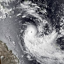 Cyclone Rewa near peak intensity on 16 January
Severe Tropical Cyclone Rewa affected six countries and caused 22 deaths on its 28-day journey across the South Pacific Ocean in December 1993 and January 1994. Cyclone Rewa developed from a tropical disturbance on 28 December south of Nauru. After forming, Rewa moved southwest through the Solomon Islands, crossing the 160th meridian east from the South Pacific basin into the Australian region. The cyclone began to strengthen steadily and turned southward, paralleling the eastern Australian coast through 31 December. Rewa reached its initial peak intensity as a Category 4 tropical cyclone on 2 January. It maintained this intensity for about 12 hours before an increase in wind shear induced its weakening by 3 January. The cyclone turned southeastward and moved back into the South Pacific basin on 4 January, before it passed over New Caledonia between 5–6 January. After affecting New Caledonia, Rewa weakened to a tropical depression and turned northwestward before re-entering the Australian basin on 10 January.
Over the following days, the cyclone showed signs of restrengthening and executed an elongated cyclonic loop to the southeast of Papua New Guinea. Rewa subsequently entered a phase of quick intensification while proceeding southeastward, peaking in intensity as a Category 5 severe tropical cyclone. It recurved toward the southwest while gradually weakening for several days. Although forecasters had predicted Rewa to make landfall near Mackay, Queensland, the cyclone began interacting with an upper-level trough on 18 January, causing it to divert to the southeast and move along the Queensland coast. Rewa transitioned into an extratropical cyclone on 20 January, with its remnants bringing heavy rain to New Zealand three days later.
The cyclone caused the deaths of 22 people on its course, affecting parts of the Solomon Islands, Papua New Guinea, Eastern Australia, New Caledonia, Vanuatu and New Zealand. Nine people in a banana dinghy en route to Rossel Island went missing at the height of the storm; they were presumed drowned after wreckage from their boat turned up at the island. In Queensland, three people died in traffic accidents caused by the storm, and another fatality occurred when a boy became trapped in a storm pipe. One death took place in New Caledonia, while flooding caused eight drownings in Papua New Guinea. Because of the severe impacts that Rewa brought, the name was retired. (Full article...) - Image 12The KPHL National Soccer League, also known as the Kumul Petroleum Holdings Limited National Soccer League for sponsorship reasons, is the men's top division of professional soccer in Papua New Guinea. It is a nationwide league formed in 2006 by Papua New Guinea Football Association.
It replaced the Papua New Guinea National Club Championship as the country's major soccer competition.
The competition has been won by only two clubs. Hekari United won the first eight editions, while Lae City have won the rest. The two clubs have met in two Grand Finals, in 2015–16 and 2019, with Lae City winning both. (Full article...) - Image 13
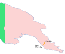
Location of the Kokoda Track within Papua New Guinea
The Kokoda Track or Trail is a single-file foot thoroughfare that runs 96 kilometres (60 mi) overland – 60 kilometres (37 mi) in a straight line – through the Owen Stanley Range in Papua New Guinea (PNG). The track was the location of the 1942 World War II battle between Japanese and Allied – primarily Australian – forces in what was then the Australian territory of Papua.
The track runs from Owers' Corner in Central Province, 50 kilometres (31 mi) east of Port Moresby, across rugged and isolated terrain which is only passable on foot, to the village of Kokoda in Oro Province. It reaches a height of 2,490 metres (8,169 ft) as it passes around the peak of Mount Bellamy. The track travels primarily through the land of the Mountain Koiari people.
Hot, humid days with intensely cold nights, torrential rainfall and the risk of endemic tropical diseases such as malaria make it a challenging trek. Hiking the trail normally takes between four and twelve days; the fastest recorded time is 16 hours 34 minutes. (Full article...) - Image 14

Dendrobium discolor, commonly known as antler orchid or golden orchid, is a species of epiphytic or lithophytic orchid in the family Orchidaceae, and are native to northern Australia, New Guinea, and part of Indonesia. It has cylindrical pseudobulbs, each with between ten and thirty five leathery leaves, and flowering stems with up to forty mostly brownish or greenish flowers with wavy and twisted sepals and petals. (Full article...) - Image 15The History of Western New Guinea refers to the history of the Indonesian western half of the island of New Guinea and other smaller islands to its west. This region was previously named Irian Jaya. The eastern half of the island is Papua New Guinea.
Human habitation is estimated to have begun between 42,000 and 48,000 years ago. Trade between New Guinea and neighboring Indonesian islands was documented as early as the seventh century, and archipelagic rule of New Guinea by the 13th. The Netherlands made claim to the region and commenced missionary work in nineteenth century. The region was incorporated into the Indonesian republic in the 1960s. Following the 1998 commencement of reforms across Indonesia, Papua and other Indonesian provinces received greater regional autonomy. In 2001, "Special Autonomy" status was granted to the region, although up to 2006, implementation had been partial. The region was divided in 2003 into the provinces of Papua and West Papua. In 2022, the new provinces of Central Papua, Highland Papua, South Papua, and Southwest Papua were created. (Full article...)
![Image 1Satellite view of the islands of New Britain and New Ireland, the two largest in the Bismarck ArchipelagoThe Bismarck Archipelago (German: Bismarck-Archipel, pronounced ['bɪsmɑrk ˌaʁçiˈpeːl]) is a group of islands off the northeastern coast of New Guinea in the western Pacific Ocean and is part of the Islands Region of Papua New Guinea. Its area is about 50,000 square km. (Full article...)](./File:Blank.png)


.jpg)


Did you know (auto-generated)

- ... that Australiformis semoni is a parasite that infests marsupials in Australia and New Guinea and whose infestation could cause debilitating ulcerative granulomatous gastritis?
- ... that until Rufina Peter and Kessy Sawang's election in August 2022, Papua New Guinea was one of only three countries without a woman in parliament?
- ... that David Dexter, who wrote the New Guinea volume in the series Australia in the War of 1939–1945, was a commando who served in East Timor and New Guinea?
- ... that Australian official Jack Emanuel was awarded the George Cross in 1971 after being stabbed to death whilst trying to resolve a land dispute with the Tolai people of New Guinea?
- ... that Dorkas Tokoro-Hanasbey, the only female member of the New Guinea Council, arrived thirty minutes late to her inauguration ceremony?
- ... that the clinical trials of British scientist Peter Pharoah helped eradicate congenital iodine deficiency syndrome (cretinism) in Papua New Guinea?
General images - show new batch
 Image 1An Australian soldier, Private George "Dick" Whittington, is aided by Papuan orderly Raphael Oimbari, near Buna on 25 December 1942. (from History of Papua New Guinea)
 Image 2Dutch expeditions in Netherlands New Guinea 1907–1915. (from History of Western New Guinea)
 Image 4Flag under German control of New Guinea. (from History of Papua New Guinea)
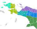 Image 5 (from New Guinea)
 Image 6Papuans on the Lorentz River, photographed during the third South New Guinea expedition in 1912–13 (from New Guinea)
 Image 7New Guinea Volunteer Rifles with captured Japanese flag, 1942 (from History of Papua New Guinea)
 Image 8Political divisions of New Guinea (from New Guinea)
 Image 10Map of New Guinea, with place names as used in English in the 1940s (from New Guinea)
 Image 12Yali Mabel, Kurulu Village War Chief at Baliem Valley (from New Guinea)
 Image 13Papuan lake dwellings with a lakatoi under sail, 1898 or before (from History of Papua New Guinea)
 Image 14New Guinea from 1884 to 1919. The Netherlands controlled the western half of New Guinea, Germany the north-eastern part, and Britain the south-eastern part. (from New Guinea)
 Image 15Highlands of Papua New Guinea (from New Guinea)
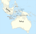 Image 16Map showing the combined landmass of Sahul formed during Pleistocene glacations (from New Guinea)
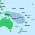
 Image 19British flag raised in Queensland 1883 (from History of Papua New Guinea)
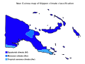 Image 20New Guinea map of Köppen climate classification (from New Guinea)
 Image 21Regions of Oceania: Australasia, Polynesia, Micronesia, and Melanesia. Australasia include the Australian landmass (including Tasmania), New Zealand, and New Guinea. (from History of Papua New Guinea)
 Image 22A 1644 map of New Guinea and the surrounding area (from New Guinea)
 Image 23Australian troops at Milne Bay, Papua.The Australian garrison was the first to inflict defeat on the Imperial Japanese Army during World War II at the Battle of Milne Bay of Aug–Sep 1942. (from History of Papua New Guinea)
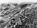 Image 24Australian soldiers resting in the Finisterre Ranges of New Guinea while en route to the front line (from New Guinea)
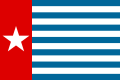 Image 25The Morning Star, flag of West Papua, was designed by the New Guinea Council in 1961. Its display is prohibited in some circumstances in Indonesia. (from History of Western New Guinea)
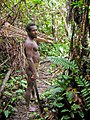

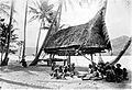 Image 28Group of natives at Mairy Pass. Mainland of British New Guinea in 1885. (from New Guinea)
- Image 29The continent of Sahul before the rising ocean sundered Australia and New Guinea after the last ice age (from New Guinea)

 Image 31A Japanese military map of New Guinea from 1943 (from New Guinea)
- Image 32Regions of Oceania: Australasia, Polynesia, Micronesia, and Melanesia. Physiographically, Australasia includes the Australian landmass (including Tasmania), New Zealand, and New Guinea (from New Guinea)
 Image 34Topographical map of New Guinea (from New Guinea)
- Image 36A typical map from the Golden Age of Netherlandish cartography. Australasia during the Golden Age of Dutch exploration and discovery (ca. 1590s–1720s): including Nova Guinea (New Guinea), Nova Hollandia (mainland Australia), Van Diemen's Land (Tasmania), and Nova Zeelandia (New Zealand). (from History of Papua New Guinea)


.svg)

.jpg)


.png)
.jpg)


Related portals
In the news
- 10 May 2024 – Palestine and the United Nations
- The United Nations General Assembly votes 143–9 with 25 abstentions to approve a resolution granting Palestine new rights and privileges, and to reconsider Palestine's request to become a UN member. The nine countries that opposed the resolution were Argentina, the Czech Republic, Hungary, Israel, Micronesia, Nauru, Palau, Papua New Guinea and the United States. (AP) (The National)
- 15 April 2024 –
- A magnitude 6.5 earthquake strikes West New Britain Province, Papua New Guinea. No damage or casualties are reported. (ABC News)
WikiProjects
General topics
Categories

Associated Wikimedia
The following Wikimedia Foundation sister projects provide more on this subject:
-
 Commons
Free media repository -
 Wikibooks
Free textbooks and manuals -
 Wikidata
Free knowledge base -
 Wikinews
Free-content news -
 Wikiquote
Collection of quotations -
 Wikisource
Free-content library -
 Wikiversity
Free learning tools -
 Wiktionary
Dictionary and thesaurus
External media


