Portal:Myanmar
Wikipedia portal for content related to Myanmar (Burma) / From Wikipedia, the free encyclopedia
Portal maintenance status: (March 2022)
|
ကြိုဆိုပါတယ်။ / Welcome to the Myanmar Portal 

Myanmar, officially the Republic of the Union of Myanmar and also known as Burma (the official name until 1989), is a country in Southeast Asia. It is the largest country by area in Mainland Southeast Asia and has a population of about 55 million. It is bordered by Bangladesh and India to its northwest, China to its northeast, Laos and Thailand to its east and southeast, and the Andaman Sea and the Bay of Bengal to its south and southwest. The country's capital city is Naypyidaw, and its largest city is Yangon (formerly Rangoon).
Myanmar is a member of the East Asia Summit, Non-Aligned Movement, ASEAN, and BIMSTEC, but it is not a member of the Commonwealth of Nations despite once being part of the British Empire. Myanmar is a Dialogue Partner of the Shanghai Cooperation Organization. The country is very rich in natural resources, such as jade, gems, oil, natural gas, teak and other minerals, as well as also endowed with renewable energy, having the highest solar power potential compared to other countries of the Great Mekong Subregion. However, Myanmar has long suffered from instability, factional violence, corruption, poor infrastructure, as well as a long history of colonial exploitation with little regard to human development. In 2013, its GDP (nominal) stood at US$56.7 billion and its GDP (PPP) at US$221.5 billion. The income gap in Myanmar is among the widest in the world, as a large proportion of the economy is controlled by cronies of the military junta. Myanmar is one of the least developed countries; as of 2020, according to the Human Development Index, it ranks 147 out of 189 countries in terms of human development, the lowest in Southeast Asia. Since 2021, more than 600,000 people were displaced across Myanmar due to the surge in violence post-coup, with more than 3 million people in dire need of humanitarian assistance. (Full article...)
Selected articles - load new batch
![Image 1The Shwezigon Pagoda or Shwezigon Paya (ရွှေစည်းခုံဘုရား [ɕwèzíɡòʊɰ̃ pʰəjá]) is a Buddhist stupa located in Nyaung-U, Myanmar. A prototype of Burmese stupas, it consists of a circular gold leaf-gilded stupa surrounded by smaller temples and shrines. Construction of the Shwezigon Pagoda began during the reign of King Anawrahta (r. 1044–1077), the founder of the Pagan Empire, in 1059–1060 and was completed in 1102, during the reign of his son King Kyansittha. Over the centuries the pagoda had been damaged by many earthquakes and other natural calamities, and has been refurbished several times. In recent renovations it has been covered by more than 30,000 copper plates. However, the lowest level terraces have remained as they were.This pagoda, a sacred Buddhist religious place, is believed to enshrine a bone and tooth of Gautama Buddha. The pagoda is in the form of a cone formed by five square terraces with a central solid core. There are footprints below the four standing Buddha statues here. Jataka legends are depicted on glazed terra-cotta tiles set into three rectangular terraces. At the entrance of the pagoda there are large statues of guardians of the temple. There are also four bronze standing statues of Buddha which are stated to be of the current age Buddha. At the outer limits of the pagoda there are 37 nats deified along with an intricately carved wooden sculpture of Thagyamin, the Burmese version of the Indian god Indra. Within the compound of the Shwezigon Pagoda there is a stone pillar containing Mon language inscriptions dedicated by Kyansittha. (Full article...)](//upload.wikimedia.org/wikipedia/en/d/d2/Blank.png) Image 1
Image 1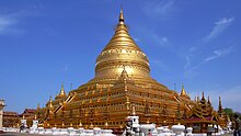
The Shwezigon Pagoda or Shwezigon Paya (ရွှေစည်းခုံဘုရား [ɕwèzíɡòʊɰ̃ pʰəjá]) is a Buddhist stupa located in Nyaung-U, Myanmar. A prototype of Burmese stupas, it consists of a circular gold leaf-gilded stupa surrounded by smaller temples and shrines. Construction of the Shwezigon Pagoda began during the reign of King Anawrahta (r. 1044–1077), the founder of the Pagan Empire, in 1059–1060 and was completed in 1102, during the reign of his son King Kyansittha. Over the centuries the pagoda had been damaged by many earthquakes and other natural calamities, and has been refurbished several times. In recent renovations it has been covered by more than 30,000 copper plates. However, the lowest level terraces have remained as they were.
This pagoda, a sacred Buddhist religious place, is believed to enshrine a bone and tooth of Gautama Buddha. The pagoda is in the form of a cone formed by five square terraces with a central solid core. There are footprints below the four standing Buddha statues here. Jataka legends are depicted on glazed terra-cotta tiles set into three rectangular terraces. At the entrance of the pagoda there are large statues of guardians of the temple. There are also four bronze standing statues of Buddha which are stated to be of the current age Buddha. At the outer limits of the pagoda there are 37 nats deified along with an intricately carved wooden sculpture of Thagyamin, the Burmese version of the Indian god Indra. Within the compound of the Shwezigon Pagoda there is a stone pillar containing Mon language inscriptions dedicated by Kyansittha. (Full article...)- Image 2

Burmese nat statues in the shrine
The nats (နတ်; MLCTS: nat; IPA: [naʔ]) are god-like spirits venerated in Myanmar and neighbouring countries in conjunction with Buddhism. They are divided between the 37 Great Nats who were designated that status by King Anawrahta when he formalized the official list of nats. Most of the 37 Great Nats were human beings who met violent deaths.
There are two types of nats in Burmese Belief: nat sein (နတ်စိမ်း) which are humans that were deified after their deaths and all the other nats which are spirits of nature (spirits of water, trees etc.). (Full article...) - Image 3
The State Administration Council (Burmese: နိုင်ငံတော်စီမံအုပ်ချုပ်ရေးကောင်စီ; abbreviated SAC or နစက) is the military junta currently governing Myanmar, established by Commander-in-Chief of Defence Services Min Aung Hlaing following the February 2021 coup d'état and the declaration of a state of emergency by the National Defence and Security Council. Under the constitution, the Commander-in-Chief holds absolute legislative, executive, and judicial power during a state of emergency. Min Aung Hlaing has delegated his legislative power to the SAC, which he chairs. It has formed a provisional administration, also led by Min Aung Hlaing as Prime Minister of Myanmar.
The Committee Representing Pyidaungsu Hluttaw (CRPH) has designated the SAC as a "terrorist group", and SAC's legitimacy is contested by the competing National Unity Government of Myanmar (NUG). (Full article...) - Image 4

The Burmese–Siamese War also known as the War of the second fall (Thai: สงครามคราวเสียกรุงครั้งที่สอง, Burmese: ယိုးဒယား-မြန်မာစစ် (၁၇၆၅–၁၇၆၇)) was the second military conflict between Burma under Konbaung dynasty and Ayutthaya Kingdom under Siamese Ban Phlu Luang dynasty that lasted from 1765 until 1767, and the war that ended the 417-year-old Ayutthaya Kingdom.
Burma under the new Konbaung dynasty emerged powerful in mid-eighteenth century. King Alaungpaya the dynastic founder led his Burmese forces of 40,000 men, with his son Prince of Myedu as vanguard commander, invaded Siam in late 1759 to early 1760. The Burmese reached and attacked Ayutthaya in April 1760 but the arrival of rainy season and sudden illness of Alaungpaya prompted the Burmese to retreat. Traditional Siamese strategy of passive stand in Ayutthaya citadel against Burmese besiegers worked for one last time, postponing the eventual fall of Ayutthaya for seven years. Alaungpaya died on May 1760 on his way from Siam back to Burma. Burmese invasion of Siam in 1760, in which the Burmese, particularly Prince Myedu, had an opportunity to learn about Siamese geography, strategy and tactics and to reflect about their own flaws in the campaign, served as the foundation of the next Burmese invasion in 1765–1767. Prince Myedu ascended the Burmese throne as King Hsinbyushin in late 1763. Hsinbyushin inherited military energy and prowess from his father Alaungpaya and was determined to accomplish the unfinished mission of conquering Ayutthaya unattained by his father. (Full article...) - Image 5
 Map of territorial gains made by the Arakan Army since 2023
Violent clashes have been ongoing in the northern part of Myanmar's Rakhine State since October 2016. Insurgent attacks by the Arakan Rohingya Salvation Army (ARSA) have led to sectarian violence perpetrated by Myanmar's military and the local Buddhist population against predominantly Muslim Rohingya civilians. The conflict has sparked international outcry and was described as an ethnic cleansing by the United Nations High Commissioner for Human Rights. In August 2017, the situation worsened and hundreds of thousands of refugees fled Myanmar into Bangladesh, with an estimated 500,000 refugees having arrived by 27 September 2017. In January 2019, Arakan Army insurgents raided border police posts in Buthidaung Township, joining the conflict and beginning their military campaign in northern Rakhine State against the Burmese military.
The Muslim Rohingya minority in the region has historically experienced persecution. Laws such as the 1982 Myanmar nationality law ban Rohingya people from obtaining citizenship, and military operations in 1978, 1991 and 1992 against the Rohingya have led to their displacement throughout Rakhine State. Sectarian violence between Buddhist Rakhines and Muslim Rohingyas in 2012 and the 2013 have also caused mass displacements. (Full article...) - Image 6
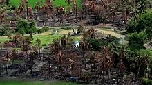 Destroyed village in Rakhine State, September 2017
The Rohingya genocide is a series of ongoing persecutions and killings of the Muslim Rohingya people by the military of Myanmar. The genocide has consisted of two phases to date: the first was a military crackdown that occurred from October 2016 to January 2017, and the second has been occurring since August 2017. The crisis forced over a million Rohingya to flee to other countries. Most fled to Bangladesh, resulting in the creation of the world's largest refugee camp, while others escaped to India, Thailand, Malaysia, and other parts of South and Southeast Asia, where they continue to face persecution. Many other countries consider these events ethnic cleansing.
The persecution of Rohingya Muslims in Myanmar dates back to at least the 1970s. Since then, the Rohingya people have been persecuted on a regular basis by the government and Buddhist nationalists. In late 2016, Myanmar's armed forces and police launched a major crackdown against the people in Rakhine State which is located in the country's northwestern region. The Burmese military was accused of committing ethnic cleansing and genocide by various United Nations agencies, International Criminal Court officials, human rights groups, journalists, and governments. The UN found evidence of wide-scale human rights violations, including extrajudicial killings; summary executions; gang rapes; arson of Rohingya villages, businesses, and schools; and infanticides. At least 6,700 Rohingya were killed in the first month of attacks, between 25 August and September 24, 2017. The Burmese government dismissed these findings by stating they are "exaggerations". Using statistical extrapolations which were based on surveys which were conducted with a total of 3,321 Rohingya refugee households in Cox's Bazar, Bangladesh, a study which was conducted in January 2018 estimated that the military and the local Rakhine population killed at least 25,000 Rohingya people and perpetrated gang rapes and other forms of sexual violence against 18,000 Rohingya women and girls. They estimated that 116,000 Rohingya were beaten, and 36,000 were thrown into fires. (Full article...) - Image 7
 သာသနာ့အလံတော်
Flag of Sāsana
Buddhism (Burmese: ဗုဒ္ဓဘာသာ), specifically Theravāda Buddhism (Burmese: ထေရဝါဒဗုဒ္ဓဘာသာ), is the official and state religion of Myanmar since 1961, and practiced by nearly 90% of the population. It is the most religious Buddhist country in terms of the proportion of monks in the population and proportion of income spent on religion. Adherents are most likely found among the dominant Bamar people, Shan, Rakhine, Mon, Karen, and Chinese who are well integrated into Burmese society. Monks, collectively known as the sangha (community), are venerated members of Burmese society. Among many ethnic groups in Myanmar, including the Bamar and Shan, Theravada Buddhism is practiced in conjunction with the worship of nats, which are spirits who can intercede in worldly affairs.
Regarding the practice of Buddhism, two popular practices stand out: merit-making and vipassanā meditation. There is also the less popular weizza path. Merit-making is the most common path undertaken by Burmese Buddhists. This path involves the observance of the Five precepts and accumulation of good merit through charity (dana, often to monks) and good deeds to obtain a favorable rebirth. The meditation path, which has gained ground since the early 1900s, is a form of Buddhist meditation which is seen as leading to awakening and can involve intense meditation retreats. The weizza path is an esoteric system of occult practices (such as recitation of spells, samatha and alchemy) believed to lead to life as a weizza (Burmese: ဝိဇ္ဇာ Pali: vijjā), a semi-immortal and supernatural being who awaits the appearance of the future Buddha, Maitreya (Arimeitaya). (Full article...) - Image 8

The Provisional Government of the Republic of the Union of Myanmar (Burmese: ပြည်ထောင်စုသမ္မတမြန်မာနိုင်ငံတော် အာဏာသိမ်းခေါင်းဆောင်), is the provisional government of Myanmar under the current military junta, the State Administration Council. On 1 August 2021, it replaced the Management Committee of the State Administration Council, which had been in place since 19 February 2021, following the 2021 Myanmar coup d'état. Some ministers were appointed by Min Aung Hlaing immediately following the coup on 1 February, in his capacity as Commander-in-Chief of Defence Services exercising emergency powers.
Due to the state of emergency, the cabinet is led by Prime Minister Min Aung Hlaing rather than Acting President Myint Swe, despite the president being the constitutional head of government. (Full article...) - Image 9Kale Kye-Taung Nyo (Burmese: ကလေး ကျေးတောင် ညို, [kəlé tɕédàʊɰ̃ɲò]; also spelled Kale Kyetaungnyo or Kalekyetaungnyo; 1385–1426) was king of Ava from 1425 to 1426, and governor of Kale Kye-Taung (Kalay) from 1406 to 1425. A top military commander during the reigns of kings Minkhaung I and Thihathu of Ava, Prince Min Nyo came to power in 1425 by overthrowing his eight-year-old nephew King Min Hla with the help of his lover Queen Shin Bo-Me. But Nyo himself was overthrown less than seven months later in 1426 by his fellow senior commander and long-time rival Gov. Thado of Mohnyin.
The eldest son of King Tarabya of Ava, Prince Nyo was the heir presumptive during his father's brief reign in 1400. He did not succeed to the throne but became a son-in-law of the successor, his half-uncle King Minkhaung I (r. 1400–1421), who in 1406 sent him to govern Kale, a remote Shan state in the northwest. The prince proved a loyal and able vassal, keeping the frontier region quiet while leading several campaigns in Ava's long running war against Hanthawaddy Pegu between 1408 and 1423. Nyo and Thado rose to be the deputy commanders-in-chief in 1412, and after the death of Crown Prince Minye Kyawswa in 1415, the duo became the leading commanders of the Ava military. (Full article...) - Image 10
 The Pyu realm in the red zone
The Pyu city-states (Burmese: ပျူ မြို့ပြ နိုင်ငံများ) were a group of city-states that existed from about the 2nd century BCE to the mid-11th century in present-day Upper Myanmar (Burma). The city-states were founded as part of the southward migration by the Tibeto-Burman-speaking Pyu people, the earliest inhabitants of Burma of whom records are extant. The thousand-year period, often referred to as the Pyu millennium, linked the Bronze Age to the beginning of the classical states period when the Pagan Kingdom emerged in the late 9th century.
The major Pyu city-states were all located in the three main irrigated regions of Upper Burma: the Mu River Valley, the Kyaukse plains and Minbu region, around the confluence of the Irrawaddy and Chindwin Rivers. Five major walled cities- Beikthano, Maingmaw, Binnaka, Hanlin, and Sri Ksetra- and several smaller towns have been excavated throughout the Irrawaddy River basin. Hanlin, founded in the 1st century AD, was the largest and most important city until around the 7th or 8th century when it was superseded by Sri Ksetra (near modern Pyay) at the southern edge of the Pyu Realm. Twice as large as Halin, Sri Ksetra was eventually the largest and most influential Pyu centre. Only the city-states of Halin, Beikthano and Sri Ksetra are designated as UNESCO World Heritage Sites, where the other sites can be added in the future for an extension nomination. (Full article...)
![Image 1The Shwezigon Pagoda or Shwezigon Paya (ရွှေစည်းခုံဘုရား [ɕwèzíɡòʊɰ̃ pʰəjá]) is a Buddhist stupa located in Nyaung-U, Myanmar. A prototype of Burmese stupas, it consists of a circular gold leaf-gilded stupa surrounded by smaller temples and shrines. Construction of the Shwezigon Pagoda began during the reign of King Anawrahta (r. 1044–1077), the founder of the Pagan Empire, in 1059–1060 and was completed in 1102, during the reign of his son King Kyansittha. Over the centuries the pagoda had been damaged by many earthquakes and other natural calamities, and has been refurbished several times. In recent renovations it has been covered by more than 30,000 copper plates. However, the lowest level terraces have remained as they were.This pagoda, a sacred Buddhist religious place, is believed to enshrine a bone and tooth of Gautama Buddha. The pagoda is in the form of a cone formed by five square terraces with a central solid core. There are footprints below the four standing Buddha statues here. Jataka legends are depicted on glazed terra-cotta tiles set into three rectangular terraces. At the entrance of the pagoda there are large statues of guardians of the temple. There are also four bronze standing statues of Buddha which are stated to be of the current age Buddha. At the outer limits of the pagoda there are 37 nats deified along with an intricately carved wooden sculpture of Thagyamin, the Burmese version of the Indian god Indra. Within the compound of the Shwezigon Pagoda there is a stone pillar containing Mon language inscriptions dedicated by Kyansittha. (Full article...)](./File:Blank.png)


_map_-_EN_-_001.jpg)


Did you know (auto-generated) - load new batch

- ... that Aung Myo Min, Union Minister of Human Rights for the National Unity Government of Myanmar, is the country's first openly LGBT minister?
- ... that the Burmese Buddhist monk Sagyo Thu-Myat successfully lobbied for the recalibration of the Burmese calendar?
- ... that the mission of the United Nations special envoy on Myanmar has been called a "diplomatic graveyard"?
- ... that while defending Zaw Myint Maung following his arrest by the Myanmar junta, lawyer Ywet Nu Aung was herself arrested and charged?
- ... that Esther Ze Naw, who appeared on the 2021 Time 100, was one of the few people in Myanmar who protested against Aung San Suu Kyi's defence of the military at the International Court of Justice in December 2019?
- ... that Rangoon kept its own time for more than two decades after Burma Standard Time first came into effect?
- ... that one academic described the introduction of femboys to Myanmar as a tactic to achieve an "ideological revolution"?
- ... that as part of the coronation of Mindon Min, the square yuzana around the capital was designated a sanctuary?
Related portals and projects
Southeast Asia
Other Countries
General images - load new batch
 Image 1Boxing match, 19th-century watercolour (from Culture of Myanmar)
 Image 2Saint Mary's Cathedral in Downtown Yangon is the largest Roman Catholic cathedral in Burma. (from Culture of Myanmar)
 Image 3A group of Buddhist worshipers at Shwedagon Pagoda, an important religious site for Burmese Buddhists (from Culture of Myanmar)
 Image 4Pagan Kingdom during Narapatisithu's reign. Burmese chronicles also claim Kengtung and Chiang Mai. Core areas shown in darker yellow. Peripheral areas in light yellow. Pagan incorporated key ports of Lower Burma into its core administration by the 13th century. (from History of Myanmar)
 Image 5Portuguese ruler and soldiers mounting an Elephant. Philips, Jan Caspar (draughtsman and engraver) (from History of Myanmar)
 Image 6British soldiers dismantling cannons belonging to King Thibaw's forces, Third Anglo-Burmese War, Ava, 27 November 1885. Photographer: Hooper, Willoughby Wallace (1837–1912). (from History of Myanmar)
 Image 7A large fracture on the Mingun Pahtodawgyi caused by the 1839 Ava earthquake. (from Geography of Myanmar)
 Image 8The shores of Irrawaddy River at Nyaung-U, Bagan (from Geography of Myanmar)
 Image 10British soldiers on patrol in the ruins of the Burmese town of Bahe during the advance on Mandalay, January 1945. (from History of Myanmar)
 Image 12A bull fight, 19th-century watercolour (from Culture of Myanmar)
 Image 13British soldiers remove their shoes at the entrance of Shwedagon Pagoda. To the left, a sign reads "Foot wearing is strictly prohibited" in Burmese, English, Tamil, and Urdu. (from Culture of Myanmar)
 Image 15Salween river at Mae Sam Laep on the Thai-Myanmar border (from Geography of Myanmar)
 Image 17Sculpture of Myanmar mythical lion (from Culture of Myanmar)
 Image 18Protesters in Yangon with a banner that reads non-violence: national movement in Burmese, in the background is Shwedagon Pagoda. (from History of Myanmar)
 Image 19Recorder's Court on Sule Pagoda Road, with the Sule Pagoda at the far end, Rangoon, 1868. Photographer: J. Jackson. (from History of Myanmar)
 Image 20Myanmar (Burma) map of Köppen climate classification (from Geography of Myanmar)
 Image 22Aerial view of a burned Rohingya village in Rakhine state, September 2017 (from History of Myanmar)
 Image 23Protesters in Yangon carrying signs reading "Free Daw Aung San Suu Kyi" on 8 February 2021. (from History of Myanmar)
 Image 24Former US President Barack Obama poses barefoot on the grounds of Shwedagon Pagoda, one of Myanmar's major Buddhist pilgrimage sites. (from Culture of Myanmar)
 Image 2519th-century funeral cart and spire, which would form part of the procession from the home to the place of cremation (from Culture of Myanmar)
 Image 26A wedding procession, with the groom and bride dressed in traditional Burmese wedding clothes, reminiscent of royal attire (from Culture of Myanmar)
 Image 28Two female musicians play the saung at a performance in Mandalay. (from Culture of Myanmar)
 Image 29Hlei pyaingbwè - a Burmese regatta (from Culture of Myanmar)
 Image 30Myinhkin thabin - equestrian sport (from Culture of Myanmar)
 Image 31The paddle steamer Ramapoora (right) of the British India Steam Navigation Company on the Rangoon river having just arrived from Moulmein. 1895. Photographers: Watts and Skeen (from History of Myanmar)
 Image 32The restored Taungoo or Nyaungyan dynasty c. 1650 CE. (from History of Myanmar)
 Image 33Vegetable stall on the roadside at the Madras Lancer Lines, Mandalay, January 1886. Photographer: Hooper, Willoughby Wallace (1837–1912). (from History of Myanmar)
 Image 34Political Map of Burma (Myanmar) c. 1450 CE. (from History of Myanmar)
 Image 35A theatrical performance of the Mon dance (from Culture of Myanmar)
 Image 36Grandfather Island, Dawei (from Geography of Myanmar)
 Image 37Temples at Mrauk U, was the capital of the Mrauk U Kingdom, which ruled over what is now Rakhine State. (from History of Myanmar)

 Image 40Aung San Suu Kyi addresses crowds at the NLD headquarters shortly after her release. (from History of Myanmar)


_headquarter.jpg)
Major topics
Categories

More topics
|
|
|
Associated Wikimedia
The following Wikimedia Foundation sister projects provide more on this subject:
-
 Commons
Free media repository -
 Wikibooks
Free textbooks and manuals -
 Wikidata
Free knowledge base -
 Wikinews
Free-content news -
 Wikiquote
Collection of quotations -
 Wikisource
Free-content library -
 Wikiversity
Free learning tools -
 Wikivoyage
Free travel guide -
 Wiktionary
Dictionary and thesaurus


