Pomeroon-Supenaam
Region of Guyana From Wikipedia, the free encyclopedia
Region of Guyana From Wikipedia, the free encyclopedia
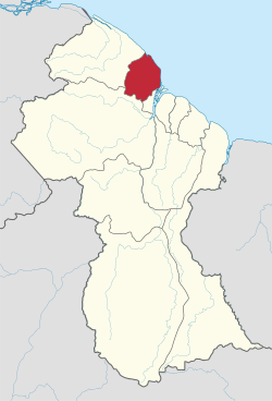
Pomeroon-Supenaam (Region 2) is a region of Guyana. It borders the Atlantic Ocean to the north, the region of Essequibo Islands-West Demerara to the east, the region of Cuyuni-Mazaruni to the south and the region of Barima-Waini to the west. Pomeroon-Supenaam contains the town of Anna Regina and the villages of Charity, Pickersgill, Spring Garden and Suddie. In 2012, an official census by the Government of Guyana listed the population of the Pomeroon-Supenaam Region at 46,810.[2]
Pomeroon-Supenaam
Region 2 | |
|---|---|
Administrative Region | |
 | |
 Map of Guyana showing Pomeroon-Supenaam region | |
| Country | |
| Regional Capital | Anna Regina |
| Area | |
| • Total | 6,195 km2 (2,392 sq mi) |
| Population (2012 census) | |
| • Total | 46,810 |
| • Density | 7.6/km2 (20/sq mi) |
| Time zone | UTC-4 |
| [1] | |
There are three lakes on the Essequibo Coast: Capoey (near Anna Regina), Mainstay and Hot and Cold. The three lakes symbolize three of the standard elements, with earth being represented by the land.
The Government of Guyana has administered three official censuses since the 1980 administrative reforms, in 1980, 1991 and 2002.[3] In 2002, the population of Pomeroon-Supenaam was recorded at 49,253 people.[2] Official census records for the population of the Pomeroon-Supenaam region are as follows:
(including name variants):[4]
Venezuela has renewed its claim to the Essequibo region, west of the Essequibo river.[5] The controversial status of the border is subject to the Geneva Agreement, which was signed by the United Kingdom, Venezuela and British Guiana on February 17, 1966.
Seamless Wikipedia browsing. On steroids.
Every time you click a link to Wikipedia, Wiktionary or Wikiquote in your browser's search results, it will show the modern Wikiwand interface.
Wikiwand extension is a five stars, simple, with minimum permission required to keep your browsing private, safe and transparent.