Panketal
Municipality in Brandenburg, Germany From Wikipedia, the free encyclopedia
Municipality in Brandenburg, Germany From Wikipedia, the free encyclopedia
Panketal is a municipality in the district of Barnim, in Brandenburg, Germany. It is situated 15 km northeast of Berlin (centre).
Panketal | |
|---|---|
 Town hall | |
 Coat of arms | |
Location of Panketal within Barnim district  | |
 Panketal  Panketal | |
| Coordinates: 52°37′59″N 13°33′00″E | |
| Country | Germany |
| State | Brandenburg |
| District | Barnim |
| Subdivisions | 2 Ortsteile |
| Government | |
| • Mayor (2018–26) | Maximilian Wonke[1] (SPD) |
| Area | |
| • Total | 25.84 km2 (9.98 sq mi) |
| Elevation | 60 m (200 ft) |
| Population (2022-12-31)[2] | |
| • Total | 20,854 |
| • Density | 810/km2 (2,100/sq mi) |
| Time zone | UTC+01:00 (CET) |
| • Summer (DST) | UTC+02:00 (CEST) |
| Postal codes | 16341 |
| Dialling codes | 030 |
| Vehicle registration | BAR |
| Website | www.panketal.de |
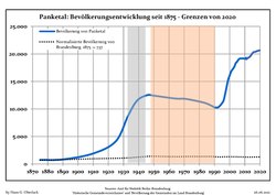
Panketal emerged in 2003 by merging the municipalities Zepernick and Schwanebeck. Since 1996, the population increased by 52.8%.[3]
From 1815 to 1947, the constituent localities of Panketal were part of the Prussian Province of Brandenburg, from 1947 to 1952 of the State of Brandenburg, from 1952 to 1990 of the East German Bezirk Frankfurt and since 1990 again of Brandenburg.
|
|
|
In 2006 a ropes course has been set up in the district Hobrechtsfelde. The ropes course has some 20 different training units. It was subsidized by Panketal with a total sum of 150,000 €.[5]


Seamless Wikipedia browsing. On steroids.
Every time you click a link to Wikipedia, Wiktionary or Wikiquote in your browser's search results, it will show the modern Wikiwand interface.
Wikiwand extension is a five stars, simple, with minimum permission required to keep your browsing private, safe and transparent.