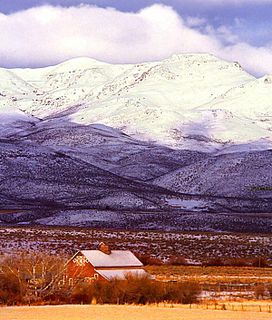
Owyhee Mountains
Mountain range in Idaho and Oregon, USA From Wikipedia, the free encyclopedia
Mountain range in Idaho and Oregon, USA From Wikipedia, the free encyclopedia
The Owyhee Mountains are a mountain range in Owyhee County, Idaho and Malheur County, Oregon.[2]
| Owyhee Mountains | |
|---|---|
 Owyhee Mountains and Noble Horse Barn viewed from the east | |
| Highest point | |
| Peak | Hayden Peak[1], Owyhee County, Idaho |
| Elevation | 2,561 m (8,402 ft) |
| Dimensions | |
| Length | 40 mi (64 km) NNW-SSE |
| Geography | |
| Country | United States |
| State(s) | Idaho, and Oregon |
| District(s) | Owyhee County, Idaho and Malheur County, Oregon |
| Range coordinates | 42°58′51″N 116°39′31″W |
| Parent range | Owyhee Mountain Range |
| Topo map | USGS Cinnabar Mountain |
Mahogany Mountain and the associated volcanic craters of the Lake Owyhee volcanic field are in the Owyhee Mountains of Oregon just east of the Owyhee Reservoir on the Owyhee River.[3]
The southeastern end of the range including the old mining area west of Silver City is referred to as the Silver City Range.[4] About 8.3 kilometres (5.2 mi) west of Silver City is the De Lamar ghost town in Jordan Creek below the mine workings on De Lamar Mountain to the south.[4] The area was active in the late 1880s. In the 1970s mining began again with the development of open pit silver–gold mines on De Lamar Mountain.[5][6]
Seamless Wikipedia browsing. On steroids.
Every time you click a link to Wikipedia, Wiktionary or Wikiquote in your browser's search results, it will show the modern Wikiwand interface.
Wikiwand extension is a five stars, simple, with minimum permission required to keep your browsing private, safe and transparent.