Nuth
Former Municipality in Limburg, Netherlands From Wikipedia, the free encyclopedia
Former Municipality in Limburg, Netherlands From Wikipedia, the free encyclopedia
Nuth (Dutch: [nʏt] ; Limburgish: Nut [nʏt]) is a village and a former municipality in the province of Limburg, situated in the southern Netherlands. In January 2019, the municipality merged with Schinnen and Onderbanken to form Beekdaelen.[3]
Nuth
| |
|---|---|
Former Municipality | |
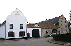
 Old farmhouse in Arensgenhout | |
| Coordinates: 50°55′N 5°53′E | |
| Country | Netherlands |
| Province | Limburg |
| Municipality | Beekdaelen |
| Merged | 2019 |
| Area | |
| • Total | 3.27 km2 (1.26 sq mi) |
| Elevation | 86 m (282 ft) |
| Population (2021)[1] | |
| • Total | 4,595 |
| • Density | 1,400/km2 (3,600/sq mi) |
| Demonym | Nutter |
| Time zone | UTC+1 (CET) |
| • Summer (DST) | UTC+2 (CEST) |
| Postcode | 6361[1] |
| Area code | 045 |
| Website | www |
The village of Nuth has 4,595 inhabitants (1 January 2021),[1] and is with that the largest village of the municipality. The town hall of the municipality Nuth was also situated in the village Nuth. The other villages in the municipality were Hulsberg with 3972 inhabitants, Schimmert with 3184, Wijnandsrade with 1623 and Vaesrade with 997 inhabitants (data: 1-1-2021). The other population centres belong to one of the following villages.
Aalbeek, Arensgenhout, Grijzegrubben, Helle, Hellebroek, Hulsberg, Laar, Schimmert, Swier, Terstraten, Vaesrade, Wijnandsrade.
Dutch Topographic map of the municipality of Nuth, June 2015
Seamless Wikipedia browsing. On steroids.
Every time you click a link to Wikipedia, Wiktionary or Wikiquote in your browser's search results, it will show the modern Wikiwand interface.
Wikiwand extension is a five stars, simple, with minimum permission required to keep your browsing private, safe and transparent.