Loading AI tools
Mountain in Tasmania, Australia From Wikipedia, the free encyclopedia
Mount Mawson is a mountain and club skifield situated within the Mount Field National Park in southern Tasmania, Australia.
| Mount Mawson | |
|---|---|
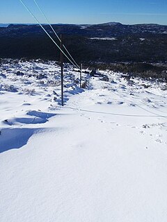
 Top of Mawson Run | |
| Location | Mount Mawson, Mount Field |
| Nearest major city | Hobart |
| Top elevation | 1,320 metres (4,330 ft) |
| Base elevation | 1,250 metres (4,100 ft) AHD[1] |
| Trails | 5 |
| Lift system | 4 rope tows |
| Website | mtmawson |
Location in Tasmania | |
| Highest point | |
| Elevation | 1,318 m (4,324 ft)AHD[2] |
| Prominence | 51 m (167 ft)[2] |
| Listing | List of highest mountains of Tasmania |
| Coordinates | 42°21′43″S 146°34′28″E[3] |
| Geography | |
| Location | Southern Tasmania, Australia |
| Geology | |
| Rock age | Jurassic |
| Mountain type | Dolerite |
The mountain has an elevation of 1,318 metres (4,324 ft) above sea level.[2] Mount Mawson's summit rises to 1,320 metres (4,330 ft)[citation needed] above sea level slightly lower than the 1,460 metres (4,790 ft) at Ben Lomond ski-field in northern Tasmania.
By road, the mountain is located 89 kilometres (55 mi) north west of Hobart and 232 kilometres (144 mi) from Launceston.
Much of Tasmania is subject to at least occasional winter snows.
The Mount Mawson ski area was established as a club skifield in 1958 and is run by the Southern Tasmanian Ski Association.[4] It is situated at around 1,250 metres (4,100 ft) above sea level[1] with four ski tows about a 20-minute walk from the car park. Mawson has three lifts: two intermediate rope tows and a third steep incline rope tow accessing steep terrain. A small amount of club accommodation is available and there are some self-catering huts in the national park.[5]
Seamless Wikipedia browsing. On steroids.
Every time you click a link to Wikipedia, Wiktionary or Wikiquote in your browser's search results, it will show the modern Wikiwand interface.
Wikiwand extension is a five stars, simple, with minimum permission required to keep your browsing private, safe and transparent.