Loading AI tools
Community District in New York, United States From Wikipedia, the free encyclopedia
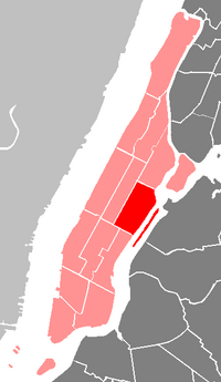
The Manhattan Community Board 8 is a New York City community board encompassing the Upper East Side, including the neighborhoods of Lenox Hill, Yorkville, and Roosevelt Island in the borough of Manhattan. It is delimited by the East River on the east, 59th Street on the south, Central Park on the west and 96th Street on the north.
Manhattan Community District 8 | |
|---|---|
 | |
| Country | |
| State | |
| City | |
| Borough | |
| Neighborhoods | |
| Government | |
| • Chairperson | Russell Squire |
| • District Manager | Will Brightbill |
| Area | |
| • Land | 2 sq mi (5 km2) |
| Population (2010) | |
| • Total | 219,920 |
| Ethnicity | |
| • Hispanic | 9.7% |
| • African-American | 2.3% |
| • White | 75.3% |
| • Asian | 10.2% |
| • Others | 2.5% |
| Time zone | UTC−5 (Eastern) |
| • Summer (DST) | UTC−4 (EDT) |
| ZIP codes | 10021, 10028, 10044, 10065, 10075, and 10128 |
| Area code | 212, 646, and 332, and 917 |
| Police Precinct | 19th (website) |
| Website | www |
| [1] [2] [3] | |
Its current Chair is Russell Squire and its District Manager is Will Brightbill.[4]
As of 2000, the Community Board had a population of 217,063, up from 210,880 in 1990 and 204,305 in 1980. Of them (as of 2000), 179,355 (82.6%) were White non-Hispanic, 6,907 (3.2%) were African-American, 13,778 (6.3%) Asian or Pacific Islander, 126 (0.1%) American Indian or Native Alaskan, 618 (0.3%) of some other race, 3,952 (1.5%) of two or more races, 3,253 (6.0%) of Hispanic origins. 4.8% of the population benefitted from public assistance as of 2009, up from 2.8% in 2000.[5]
The land area is 1,267 acres, or 2 square miles (5.2 km2).[5]
Seamless Wikipedia browsing. On steroids.
Every time you click a link to Wikipedia, Wiktionary or Wikiquote in your browser's search results, it will show the modern Wikiwand interface.
Wikiwand extension is a five stars, simple, with minimum permission required to keep your browsing private, safe and transparent.