Loading AI tools
Place in Eastern Cape, South Africa From Wikipedia, the free encyclopedia
Maclear, officially Nqanqarhu,[2] is a small town situated in the Eastern Cape province of South Africa, near the Mooi River (a tributary of the Tsitsa River), 172 km (107 mi) north of East London and 80 km (50 mi) northeast of Elliot.
Maclear
Nqanqarhu | |
|---|---|
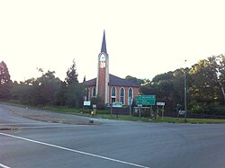
 Main street in Maclear | |
| Coordinates: 31°04′12″S 28°21′0″E | |
| Country | South Africa |
| Province | Eastern Cape |
| District | Joe Gqabi |
| Municipality | Elundini |
| Area | |
| • Total | 9.2 km2 (3.6 sq mi) |
| Elevation | 1,272 m (4,173 ft) |
| Population (2011)[1] | |
| • Total | 10,521 |
| • Density | 1,100/km2 (3,000/sq mi) |
| Racial makeup (2011) | |
| • Black African | 93.1% |
| • Coloured | 4.3% |
| • Indian/Asian | 0.2% |
| • White | 2.0% |
| • Other | 0.4% |
| First languages (2011) | |
| • Xhosa | 88.3% |
| • Afrikaans | 5.1% |
| • English | 2.7% |
| • Sotho | 2.1% |
| • Other | 1.8% |
| Time zone | UTC+2 (SAST) |
| Postal code (street) | 5480 |
| PO box | 5480 |
| Area code | 045 |
| Website | http://www.maclear.co.za/ |
It lies just north-east of Ugie. The land to the east and south was part of the former homeland of Transkei.
It was founded in 1876 as a military camp, called Nqanqaru Drift and developed rapidly, reaching municipal status in 1916. It is named after Sir Thomas Maclear (1794-1879), a famous astronomer who laid the foundation for a trigonometrical survey of the Cape Colony.[citation needed]
In 2021, the town was renamed Nqanqarhu.[3]
Maclear lies between Mount Fletcher and Ugie, in the foothills of the Drakensberg mountains, and at the intersection between the R56 and R396 roads.[5][6]
Seamless Wikipedia browsing. On steroids.
Every time you click a link to Wikipedia, Wiktionary or Wikiquote in your browser's search results, it will show the modern Wikiwand interface.
Wikiwand extension is a five stars, simple, with minimum permission required to keep your browsing private, safe and transparent.