Luiaondo
Village in Álava, Spain From Wikipedia, the free encyclopedia
Village in Álava, Spain From Wikipedia, the free encyclopedia
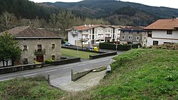
Luiaondo (Spanish: Luyando) is a village and concejo in the municipality of Ayala/Aiara, Álava, Basque Country, Spain. It is served by a Cercanías Bilbao railway station.[3]
You can help expand this article with text translated from the corresponding article in Spanish. (August 2011) Click [show] for important translation instructions.
|
Luiaondo | |
|---|---|
 View of Luiaondo | |
| Coordinates: 43°06′N 3°00′W | |
| Country | Spain |
| Autonomous community | Basque Country |
| Province | Álava |
| Comarca | Ayala |
| Municipality | Ayala/Aiara |
| Area | |
| • Total | 7.25 km2 (2.80 sq mi) |
| Elevation | 169 m (554 ft) |
| Population (2023)[2] | |
| • Total | 1,225 |
| • Density | 170/km2 (440/sq mi) |
| Postal code | 01408 |
The Árbol Malato, a tree which marked the boundary of the Lordship of Biscay, was located in Luiaondo. By the 18th century the tree had disappeared, and in 1730 a cross was built at its supposed location.[4]
Seamless Wikipedia browsing. On steroids.
Every time you click a link to Wikipedia, Wiktionary or Wikiquote in your browser's search results, it will show the modern Wikiwand interface.
Wikiwand extension is a five stars, simple, with minimum permission required to keep your browsing private, safe and transparent.