
Leimen (Baden)
Town in Baden-Württemberg, Germany / From Wikipedia, the free encyclopedia
Dear Wikiwand AI, let's keep it short by simply answering these key questions:
Can you list the top facts and stats about Leimen (Baden)?
Summarize this article for a 10 year old
Leimen (South Franconian: Lååme) is a town in north-west Baden-Württemberg, Germany. It is about seven kilometres (4+1⁄2 miles) south of Heidelberg and the third largest town of the Rhein-Neckar district after Weinheim and Sinsheim. It is also the area's industrial centre.
Leimen | |
|---|---|
 Town hall | |
_COA.svg) Coat of arms | |
Location of Leimen within Rhein-Neckar-Kreis district 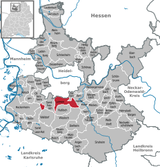 | |
 Leimen  Leimen | |
| Coordinates: 49°20′53″N 08°41′28″E | |
| Country | Germany |
| State | Baden-Württemberg |
| Admin. region | Karlsruhe |
| District | Rhein-Neckar-Kreis |
| Government | |
| • Lord mayor (2024–32) | John Ehret[1] |
| Area | |
| • Total | 20.64 km2 (7.97 sq mi) |
| Elevation | 118 m (387 ft) |
| Population (2022-12-31)[2] | |
| • Total | 27,142 |
| • Density | 1,300/km2 (3,400/sq mi) |
| Time zone | UTC+01:00 (CET) |
| • Summer (DST) | UTC+02:00 (CEST) |
| Postal codes | 69181 |
| Dialling codes | 06224, 06226 |
| Vehicle registration | HD |
| Website | www.leimen.de |
Leimen is located on the Bergstraße (Mountain Road) and on the Bertha Benz Memorial Route.
In the context of a communal reform in the 1970s, Leimen was newly created from the villages Leimen, Gauangelloch and Sankt Ilgen. In 1981, the state government of Baden-Württemberg granted Leimen the privilege to be called "town." When Leimen's population exceeded 20,000 in 1990, the city council applied for elevation to a Große Kreisstadt which was granted by the state government on 1 April 1992.