Köroğlu Mountains
Northern Turkey mountain range From Wikipedia, the free encyclopedia
Northern Turkey mountain range From Wikipedia, the free encyclopedia
Seamless Wikipedia browsing. On steroids.
Every time you click a link to Wikipedia, Wiktionary or Wikiquote in your browser's search results, it will show the modern Wikiwand interface.
Wikiwand extension is a five stars, simple, with minimum permission required to keep your browsing private, safe and transparent.
The Köroğlu Mountains (Turkish: Köroğlu Dağları) are a mountain range situated in the northern Turkey, north of Ankara. It rises along the North Anatolian Fault and the Black Sea.
| Köroğlu Mountains | |
|---|---|
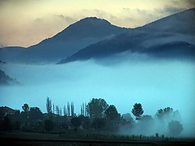
 Mist in Bolu, near the Köroğlu Mountains | |
| Highest point | |
| Peak | Köroğlu Tepesi |
| Elevation | 2,499 m (8,199 ft) |
| Coordinates | 40°40′0″N 31°47′0″E |
| Dimensions | |
| Length | 400 km (250 mi) |
| Naming | |
| Native name | Köroğlu Dağları (Turkish) |
| Geography | |
 | |
| Country | Turkey |
This range crosses the provinces of Bolu, Çankırı and Çorum, and its limits are Sakarya River, to the west, and Kızılırmak River, to the east.[1]
The highest place, situated south of Bolu, is an andesitic formation, constituted by a plateau where is situated the highest point of this range, Köroğlu Tepesi, at 2,499 m (8,200 ft) above sea level. This place has forests with firs and pines, extensive summer pastures and picturesque yaylas (mountain resorts with alpine cabins).
Recently, two ski resorts near Köroğlu Tepesi were inaugurated: Kartalkaya and Sarialan, with altitudes between 1,900 m (6,233 ft) and 2,378 m (7,802 ft).[2]