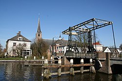
Koudekerk aan den Rijn
Village in South Holland, Netherlands From Wikipedia, the free encyclopedia
Village in South Holland, Netherlands From Wikipedia, the free encyclopedia
Koudekerk aan den Rijn (English: Cold Church upon Rhine) is a village located in the municipality of Alphen aan den Rijn, Netherlands. It is located about 4 km west of the urban centre, in the province of South Holland.
Koudekerk aan den Rijn | |
|---|---|
Village | |
 | |
| Coordinates: 52°8′5″N 4°36′7″E | |
| Country | Netherlands |
| Province | |
| Municipality | Alphen aan den Rijn |
| Area | |
| • Total | 10.31 km2 (3.98 sq mi) |
| Elevation | 0.1 m (0.3 ft) |
| Population (2021)[1] | |
| • Total | 4,105 |
| • Density | 400/km2 (1,000/sq mi) |
| Time zone | UTC+1 (CET) |
| • Summer (DST) | UTC+2 (CEST) |
| Postal code | 2396[1] |
| Dialing code | 071 |
Koudekerk aan den Rijn is a dike village which developed in the Early Middle Ages along the Luttike Rijn and the Oude Rijn.[3]
The Dutch Reformed church is a three aisled basilica-like church. The tower was built around 1400, but probably contains 13th century elements. The 15th century was dedicated to Aleid van Poelgeest who was killed in 1392. The church and tower were extensively restored between 1935 and 1936.[3]
Groot-Poelgeest Castle was first mentioned in 1326, but probably dated from around 1250. The castle started to deteriorate after 1705 and it turned into a ruin. The tower, the castle island and a carriage house remain.[4]
Koudekerk aan den Rijn was a separate municipality until 1991, when it became part of Rijnwoude. Until 1938, the municipality was known as Koudekerk.[5] Since 2014 Koudekerk is part of the city Alphen aan den Rijn
Seamless Wikipedia browsing. On steroids.
Every time you click a link to Wikipedia, Wiktionary or Wikiquote in your browser's search results, it will show the modern Wikiwand interface.
Wikiwand extension is a five stars, simple, with minimum permission required to keep your browsing private, safe and transparent.