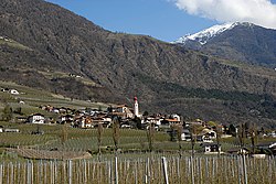
Kastelbell-Tschars
Comune in Trentino-Alto Adige/Südtirol, Italy From Wikipedia, the free encyclopedia
Comune in Trentino-Alto Adige/Südtirol, Italy From Wikipedia, the free encyclopedia
Kastelbell-Tschars (German: [ˌkastl̩ˈbɛl ˈtʃaːɐ̯s]; Italian: Castelbello-Ciardes [kaˌstɛlˈbɛllo ˈtʃardes]) is a comune (municipality) in South Tyrol in northern Italy, located about 40 kilometres (25 mi) northwest of Bolzano.
Kastelbell-Tschars | |
|---|---|
| Gemeinde Kastelbell-Tschars Comune di Castelbello-Ciardes | |
 | |
| Coordinates: 46°38′N 10°54′E | |
| Country | Italy |
| Region | Trentino-Alto Adige/Südtirol |
| Province | South Tyrol (BZ) |
| Frazioni | Kastelbell (Castelbello), Tschars (Ciardes), Freiberg (Montefranco), Galsaun (Colsano), Juval (Juvale), Latschinig (Lacinigo), Tomberg (Montefontana), Trumsberg (Montetrumes) |
| Government | |
| • Mayor | Gustav Tappeiner |
| Area | |
| • Total | 53.9 km2 (20.8 sq mi) |
| Population (Nov. 2010)[2] | |
| • Total | 2,387 |
| • Density | 44/km2 (110/sq mi) |
| Demonym(s) | German:Kastelbeller or Tscharscher Italian: castelbellesi |
| Time zone | UTC+1 (CET) |
| • Summer (DST) | UTC+2 (CEST) |
| Postal code | 39020 |
| Dialing code | 0473 |
| Website | Official website |
As of 30 November 2010, it had a population of 2,387 and an area of 53.9 square kilometres (20.8 sq mi).[3]
Kastelbell-Tschars borders the following municipalities: Latsch, Naturns, Schnals and Ulten.
The emblem is a gules mill wheel, with eight paddles, on argent background. It retakes the insignia of Counts Hendl owners of the castle from 1531 to 1949.[4]
According to the 2011 census, 98.72% of the population speak German and 1.28% Italian as first language.[5]

Seamless Wikipedia browsing. On steroids.
Every time you click a link to Wikipedia, Wiktionary or Wikiquote in your browser's search results, it will show the modern Wikiwand interface.
Wikiwand extension is a five stars, simple, with minimum permission required to keep your browsing private, safe and transparent.