Karaçoban
District and municipality in Erzurum, Turkey From Wikipedia, the free encyclopedia
District and municipality in Erzurum, Turkey From Wikipedia, the free encyclopedia
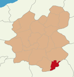
Karaçoban (Kurdish: Qere Şivan)[2] is a municipality and district of Erzurum Province, Turkey.[3] Its area is 571 km2,[4] and its population is 22,250 (2022).[1]
Karaçoban | |
|---|---|
District and municipality | |
 Map showing Karaçoban District in Erzurum Province | |
| Coordinates: 39°21′03″N 42°06′43″E | |
| Country | Turkey |
| Province | Erzurum |
| Government | |
| • Mayor | Halit Uğun (HDP) |
| Area | 571 km2 (220 sq mi) |
| Elevation | 1,550 m (5,090 ft) |
| Population (2022)[1] | 22,250 |
| • Density | 39/km2 (100/sq mi) |
| Time zone | UTC+3 (TRT) |
| Postal code | 25610 |
| Area code | 0442 |
| Climate | Dfb |
| Website | www |

There is Karayazı district in the north and northeast of the district, Hınıs district in the southwest, Bulanık district of Muş in the south and southeast, and Malazgirt district of Muş in the east. The district center is built on the narrow and long alluvial filling of the Hınıs Stream, which forms an important tributary of the Murat River, extending east-west. It is surrounded by Akdağ (2953 m) in the north, Akdoğan Mountains (2879m) in the south and Güzelbaba Mountains (2100 m) in the east.[5] There is a Lake Ahır in the northwest of the district center.
The main touristic places in Karaçoban district are Zernak Castle in Kuşluca village.[6]
There are 27 neighbourhoods in Karaçoban District:[7]
Seamless Wikipedia browsing. On steroids.
Every time you click a link to Wikipedia, Wiktionary or Wikiquote in your browser's search results, it will show the modern Wikiwand interface.
Wikiwand extension is a five stars, simple, with minimum permission required to keep your browsing private, safe and transparent.