Kankakee, Illinois
City in Illinois, United States From Wikipedia, the free encyclopedia
City in Illinois, United States From Wikipedia, the free encyclopedia
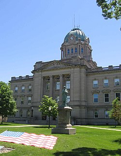
Kankakee (/ˌkæŋkəˈkiː/ KANG-kə-KEE)[3] is a city in and the county seat of Kankakee County, Illinois, United States.[4] Located on the Kankakee River, as of 2020, the city's population was 24,052.[5] Kankakee is a principal city of the Kankakee-Bourbonnais-Bradley Metropolitan Statistical Area. It serves as an anchor city in the rural plains outside Chicago.
Kankakee | |
|---|---|
 | |
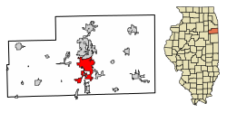
 Location of Kankakee in Illinois | |
| Coordinates: 41°07′12″N 87°51′40″W[1] | |
| Country | United States |
| State | Illinois |
| County | Kankakee |
| Established | 1853 |
| Incorporated (city) | 1865 |
| Government | |
| • Type | Mayor–council |
| • Mayor | Chris Curtis[citation needed] (R) |
| • City Council | 14 aldermen |
| Area | |
• Total | 15.62 sq mi (40.44 km2) |
| • Land | 15.14 sq mi (39.20 km2) |
| • Water | 0.48 sq mi (1.24 km2) |
| Elevation | 617 ft (188 m) |
| Population (2020) | |
• Total | 24,052 |
| • Density | 1,588.95/sq mi (613.51/km2) |
| Demonym | Kankakeean |
| Time zone | UTC−6 (CST) |
| • Summer (DST) | UTC−5 (CDT) |
| ZIP Code | 60901 |
| Area codes | 815, 779 |
| FIPS code | 17-38934 |
| GNIS feature ID | 2395489[1] |
| Website | www |

The city's name is probably derived from a corrupted version of the Miami-Illinois word teeyaahkiki, meaning "open country/exposed land/land in open/land exposed to view",[6][7][8][9][10][11][12] in reference to the area's prior status as a marsh. Kankakee was founded in 1854.[13]
According to the 2010 census, Kankakee has a total area of 14.62 square miles (37.87 km2), of which 14.14 square miles (36.62 km2) (or 96.72%) is land and 0.48 square miles (1.24 km2) (or 3.28%) is water.[14]
The Kankakee River runs through Kankakee. It is approximately 133 miles long and serves as a major attraction and defining landmark of Kankakee. The river water is refined at the Kankakee Water Company, and electricity is generated at the Kankakee River Dam, providing vital resources to the community. Its winding path, including inlets and eddies, creates desirable fishing conditions for outdoor enthusiasts.
| Climate data for Kankakee, Illinois (1991–2020 normals, extremes 1887–present) | |||||||||||||
|---|---|---|---|---|---|---|---|---|---|---|---|---|---|
| Month | Jan | Feb | Mar | Apr | May | Jun | Jul | Aug | Sep | Oct | Nov | Dec | Year |
| Record high °F (°C) | 66 (19) |
74 (23) |
85 (29) |
91 (33) |
99 (37) |
103 (39) |
103 (39) |
107 (42) |
99 (37) |
90 (32) |
79 (26) |
71 (22) |
107 (42) |
| Mean daily maximum °F (°C) | 32.5 (0.3) |
36.8 (2.7) |
48.6 (9.2) |
61.2 (16.2) |
72.5 (22.5) |
81.9 (27.7) |
84.8 (29.3) |
83.2 (28.4) |
77.9 (25.5) |
65.1 (18.4) |
49.9 (9.9) |
37.8 (3.2) |
61.0 (16.1) |
| Daily mean °F (°C) | 24.4 (−4.2) |
28.2 (−2.1) |
39.0 (3.9) |
50.3 (10.2) |
61.8 (16.6) |
71.5 (21.9) |
74.8 (23.8) |
73.1 (22.8) |
66.5 (19.2) |
54.1 (12.3) |
41.0 (5.0) |
30.0 (−1.1) |
51.2 (10.7) |
| Mean daily minimum °F (°C) | 16.3 (−8.7) |
19.7 (−6.8) |
29.4 (−1.4) |
39.4 (4.1) |
51.0 (10.6) |
61.0 (16.1) |
64.8 (18.2) |
63.0 (17.2) |
55.1 (12.8) |
43.1 (6.2) |
32.1 (0.1) |
22.1 (−5.5) |
41.4 (5.2) |
| Record low °F (°C) | −29 (−34) |
−21 (−29) |
−7 (−22) |
8 (−13) |
27 (−3) |
38 (3) |
46 (8) |
39 (4) |
30 (−1) |
18 (−8) |
1 (−17) |
−26 (−32) |
−29 (−34) |
| Average precipitation inches (mm) | 2.37 (60) |
1.94 (49) |
2.49 (63) |
3.87 (98) |
5.15 (131) |
5.21 (132) |
4.65 (118) |
3.85 (98) |
3.56 (90) |
3.40 (86) |
2.82 (72) |
2.35 (60) |
41.66 (1,058) |
| Average snowfall inches (cm) | 8.1 (21) |
3.4 (8.6) |
3.0 (7.6) |
0.3 (0.76) |
0.0 (0.0) |
0.0 (0.0) |
0.0 (0.0) |
0.0 (0.0) |
0.0 (0.0) |
0.0 (0.0) |
0.6 (1.5) |
5.3 (13) |
20.7 (53) |
| Average precipitation days (≥ 0.01 in) | 10.7 | 8.6 | 9.1 | 10.9 | 11.7 | 10.1 | 8.6 | 8.6 | 7.6 | 9.2 | 9.0 | 9.0 | 113.1 |
| Average snowy days (≥ 0.1 in) | 5.6 | 4.2 | 1.9 | 0.4 | 0.0 | 0.0 | 0.0 | 0.0 | 0.0 | 0.0 | 0.7 | 3.5 | 16.3 |
| Source: NOAA[15][16] | |||||||||||||
| Race / ethnicity (NH = non-Hispanic) | Pop 2000[20] | Pop. 2010[18] | Pop. 2020[19] | % 2000 | % 2010 | % 2020 |
|---|---|---|---|---|---|---|
| White alone (NH) | 13,130 | 10,432 | 8,096 | 47.76% | 37.88% | 33.66% |
| Black or African American alone (NH) | 11,216 | 11,128 | 9,233 | 40.80% | 40.41% | 38.39% |
| Native American or Alaska Native alone (NH) | 58 | 54 | 62 | 0.21% | 0.20% | 0.26% |
| Asian alone (NH) | 86 | 175 | 116 | 0.31% | 0.64% | 0.48% |
| Pacific Islander alone (NH) | 7 | 3 | 3 | 0.03% | 0.01% | 0.01% |
| Other race alone (NH) | 49 | 39 | 107 | 0.18% | 0.14% | 0.44% |
| Mixed race or multiracial (NH) | 401 | 599 | 916 | 1.46% | 2.18% | 3.81% |
| Hispanic or Latino (any race) | 2,544 | 5,107 | 5,519 | 9.25% | 18.55% | 22.95% |
| Total | 27,491 | 27,537 | 24,052 | 100.00% | 100.00% | 100.00% |
As of the census[21] of 2000, there were 27,561 people, 10,020 households and 6,272 families residing within the city. The population density was 2,239.8 inhabitants per square mile (864.8/km2). There were 10,965 housing units at an average density of 893.4 units per square mile (344.9 units/km2). The racial makeup of the city was 50.92% White, 41.07% African American, 0.27% Native American, 0.32% Asian, 0.03% Pacific Islander, 5.50% from other races, and 1.90% from two or more races. Hispanic or Latino residents of any race were 9.25% of the population.
There were 10,020 households, out of which 34.4% had children under the age of 18 living with them, 36.4% were married couples living together, 21.2% had a female householder with no husband present, and 37.4% were non-families. 31.5% of all households were made up of individuals, and 13.9% had someone living alone who was 65 years of age or older. The average household size was 2.60, and the average family size was 3.28.
In the city, 29.5% of the population was under the age of 18, 9.7% was from 18 to 24, 28.7% from 25 to 44, 18.7% from 45 to 64, and 13.4% was 65 years of age or older. The median age was 32 years. For every 100 females, there were 91.8 males. For every 100 females age 18 and over, there were 86.2 males.
The median income for a household in the city was $30,469, and the median income for a family was $36,428. Males had a median income of $30,894 versus $22,928 for females. The per capita income for the city was $15,479. About 18.1% of families and 21.4% of the population were below the poverty line, including 29.3% of those under age 18 and 11.7% aged 65 or over.

Library service is provided by the Kankakee Public Library.
Kankakee Valley Park District has 37 parks, comprising a total of 600 acres (2.4 km2). Facilities include an indoor ice skating rink, a recreation center, dog park, campground and a 72 boat slip marina on the Kankakee River. Fishing is plentiful as the district has 13 riverfront parks as well as a 5-acre (2.0 ha) stocked quarry.
The city has two softball complexes that have both been inducted into the Softball Hall of Fame. They host annual state and international tournaments drawing nearly 50,000 spectators throughout the year. Some Kankakee youth baseball leagues have won state championships.[24]

Kankakee is governed by the mayor council system. The city council consists of fourteen members who are elected from seven wards (two per ward). The mayor and city clerk are elected in a citywide vote.[citation needed]
Organized in 1966 by a group of citizens, Kankakee Community College was established to provide a post-secondary educational resource for the people of the Kankakee area.[25]
Public schools are part of the Kankakee School District 111, which includes five elementary schools (Edison, Mark Twain, Lincoln Cultural Center Montessori, Steuben, and Taft), two middle schools (Kennedy and King), one junior high school (Kankakee Junior High), and one high school (Kankakee High), which from 1966 to 1983 was two separate high schools, Eastridge and Westview.[26]
There are three private high schools: Bishop McNamara Catholic School (Catholic), Grace Christian Academy (non-denominational),[27][28] and Kankakee Trinity Academy (inter-denominational).[29]

Kankakee is served by the Greater Kankakee Airport, a general aviation facility located in the southern portion of Kankakee.[30]
Amtrak provides service to Kankakee from the Kankakee Amtrak Station.[31] Amtrak operates the City of New Orleans, the Illini, and the Saluki, which each run once daily in both directions.[32]
Interstate 57 runs east–west in the southern part of the city and turns north–south in the eastern part of Kankakee. United States Highways US 45 and US 52 run concurrently forming, along with Illinois Route IL 50, the major north–south thoroughfares through Kankakee. Illinois Route IL 17 is the major east–west road that bisects the city.
The River Valley Metro Mass Transit District (RVMMTD; River Valley Metro or METRO, for short) operates the region's transit bus system. Service runs seven days a week to locations in Kankakee as well as the nearby cities of Aroma Park, Bradley, Bourbonnais, and Manteno. All of the Kankakee routes are stationed out of the Chestnut & North Schuyler Transfer Station.[33] River Valley Metro operates 12 fixed-regular bus routes and two commuter routes. The Midway and University Park commuter routes were added January 5, 2014, and in August 2015 River Valley Metro added a second Midway route to its schedule. In January 2016, a second University Park route was added.
Seamless Wikipedia browsing. On steroids.
Every time you click a link to Wikipedia, Wiktionary or Wikiquote in your browser's search results, it will show the modern Wikiwand interface.
Wikiwand extension is a five stars, simple, with minimum permission required to keep your browsing private, safe and transparent.