Jahrom County
County in Fars province, Iran From Wikipedia, the free encyclopedia
Jahrom County (Persian: شهرستان جهرم) is in Fars province, Iran. Its capital is the city of Jahrom.[3]
Jahrom County
Persian: شهرستان جهرم | |
|---|---|
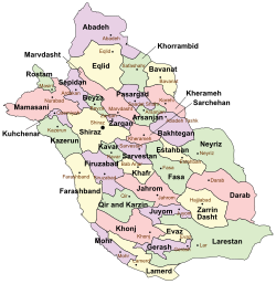
 Location of Jahrom County in Fars province (center, pink) | |
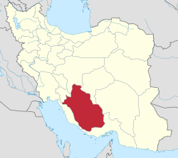
 Location of Fars province in Iran | |
| Coordinates: 28°36′N 53°22′E[1] | |
| Country | Iran |
| Province | Fars |
| Capital | Jahrom |
| Districts | Central, Kordian, Simakan |
| Population (2016)[2] | |
• Total | 228,532 |
| Time zone | UTC+3:30 (IRST) |
| Jahrom County can be found at GEOnet Names Server, at this link, by opening the Advanced Search box, entering "9206470" in the "Unique Feature Id" form, and clicking on "Search Database". | |
History
After the 2006 National Census, the village of Duzeh was elevated to the status of a city.[4] In 2019, Khafr District was separated from the county in the establishment of Khafr County.[5]
Demographics
Summarize
Perspective
Population
At the time of the 2006 census, the county's population was 197,331 in 48,335 households.[6] The following census in 2011 counted 209,312 people in 58,940 households.[7] The 2016 census measured the population of the county as 228,532 in 70,187 households.[2]
Administrative divisions
Jahrom County's population history and administrative structure over three consecutive censuses are shown in the following table.
| Administrative Divisions | 2006[6] | 2011[7] | 2016[2] |
|---|---|---|---|
| Central District | 124,134 | 137,055 | 152,953 |
| Jolgah RD | 18,977 | 21,030 | 9,257 |
| Kuhak RD | 2,134 | 1,917 | 2,062 |
| Jahrom (city) | 103,023 | 114,108 | 141,634 |
| Khafr District[a] | 42,199 | 40,535 | 42,263 |
| Aliabad RD | 7,138 | 6,454 | 5,860 |
| Gel Berenji RD | 7,281 | 8,080 | 8,650 |
| Khafr RD | 8,359 | 3,057 | 3,396 |
| Rahgan RD | 8,368 | 8,269 | 9,071 |
| Sefidar RD | 4,214 | 3,632 | 3,893 |
| Bab Anar (city) | 1,702 | 6,968 | 7,061 |
| Khavaran (city) | 5,137 | 4,075 | 4,332 |
| Kordian District | 14,025 | 13,691 | 14,851 |
| Alaviyeh RD | 6,006 | 5,542 | 5,813 |
| Qotbabad RD | 1,569 | 1,395 | 1,562 |
| Qotbabad (city) | 6,450 | 6,754 | 7,476 |
| Simakan District | 16,973 | 16,655 | 17,560 |
| Pol Beh Bala RD | 6,718 | 5,908 | 6,033 |
| Pol Beh Pain RD | 5,028 | 5,069 | 5,044 |
| Posht Par RD | 5,227 | 4,791 | 5,135 |
| Duzeh (city) | 887 | 1,348 | |
| Total | 197,331 | 209,312 | 228,532 |
| RD = Rural District | |||
Geography
Jahrom County is in the south of Fars province and has an area of 3,926 square kilometers. The county is bounded from the north by Khafr County, from the east by Fasa County and Zarrin Dasht County, from the south by Juyom County, from the west by Firuzabad County and Qir and Karzin County. The average altitude of this county is about 50 meters, and its highest point, Sefidar Peak, between Khafr county and Simakan District, is about 317 meters, and its lowest point is about 85 meters above sea level in Simian District. Qarah-Aghaj, and the Shur and Simakan rivers are among the waterways of Jahrom.[8] [citation needed]
See also
![]() Media related to Jahrom County at Wikimedia Commons
Media related to Jahrom County at Wikimedia Commons
Notes
- Transferred to Khafr County after the 2016 census[5]
References
Wikiwand - on
Seamless Wikipedia browsing. On steroids.
