Loading AI tools

Municipality in Baden-Württemberg, Germany From Wikipedia, the free encyclopedia
Inzigkofen is a municipality in the district of Sigmaringen in Baden-Württemberg in Germany. Historically, it is part of the Swabian north Alpine foreland basin.[3]
You can help expand this article with text translated from the corresponding article in German. (February 2009) Click [show] for important translation instructions.
|
Inzigkofen | |
|---|---|
 Coat of arms | |
Location of Inzigkofen within Sigmaringen district 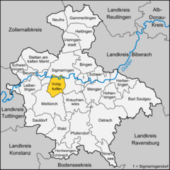 | |
 Inzigkofen  Inzigkofen | |
| Coordinates: 48°4′18″N 9°10′32″E | |
| Country | Germany |
| State | Baden-Württemberg |
| Admin. region | Tübingen |
| District | Sigmaringen |
| Government | |
| • Mayor (2020–28) | Bernd Gombold[1] |
| Area | |
| • Total | 28.76 km2 (11.10 sq mi) |
| Elevation | 590 m (1,940 ft) |
| Population (2022-12-31)[2] | |
| • Total | 2,975 |
| • Density | 100/km2 (270/sq mi) |
| Time zone | UTC+01:00 (CET) |
| • Summer (DST) | UTC+02:00 (CEST) |
| Postal codes | 72514 |
| Dialling codes | 07571 |
| Vehicle registration | SIG |
| Website | www.inzigkofen.de |

It consists of three districts:
Within Engelswies is the now-abandoned Talsberg quarry, known for its fossiliferous layers, and the site of evidence of the oldest Eurasian hominoids; a molar tooth found there in June 1973 was reported in June 2011 to have been "dated with relative precision at 17 to 17.1 Ma" (million years ago).[3]
In November 2004 Bernd Gombold,[5] was elected mayor with 96,8 % of the vote.[6][7]
Seamless Wikipedia browsing. On steroids.
Every time you click a link to Wikipedia, Wiktionary or Wikiquote in your browser's search results, it will show the modern Wikiwand interface.
Wikiwand extension is a five stars, simple, with minimum permission required to keep your browsing private, safe and transparent.