Hébertville
Municipality in Quebec, Canada From Wikipedia, the free encyclopedia
Municipality in Quebec, Canada From Wikipedia, the free encyclopedia
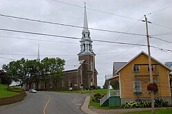
Hébertville is a municipality in Quebec, Canada.
Hébertville | |
|---|---|
 | |
 | |
| Coordinates: 48°24′N 71°41′W[1] | |
| Country | |
| Province | |
| Region | Saguenay–Lac-Saint-Jean |
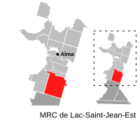
| RCM | Lac-Saint-Jean-Est |
| Constituted | December 16, 1972 |
| Government | |
| • Mayor | Marc Richard |
| • Federal riding | Lac-Saint-Jean |
| • Prov. riding | Lac-Saint-Jean |
| Area | |
| • Total | 268.80 km2 (103.78 sq mi) |
| • Land | 261.44 km2 (100.94 sq mi) |
| Population (2011)[3] | |
| • Total | 2,441 |
| • Density | 9.3/km2 (24/sq mi) |
| • Pop 2006-2011 | |
| • Dwellings | 1,204 |
| Time zone | UTC−5 (EST) |
| • Summer (DST) | UTC−4 (EDT) |
| Postal code(s) | |
| Area code(s) | 418 and 581 |
| Highways | |
| Climate | Dfb |
| Website | www |

Hébertville was founded in 1849 and is named for the priest Nicolas-Tolentin Hébert (1810-1888), the son of Jean-Baptiste Hébert, a Patriot representative jailed in Montreal in 1837. It was the first establishment to be colonised in the Lac Saint-Jean area. This municipality offered a future development near the Aulnaies Falls, situated at the heart of the village.
At this location, saw and flour mills were constructed to provide work and food for the first inhabitants.
 |
Seamless Wikipedia browsing. On steroids.
Every time you click a link to Wikipedia, Wiktionary or Wikiquote in your browser's search results, it will show the modern Wikiwand interface.
Wikiwand extension is a five stars, simple, with minimum permission required to keep your browsing private, safe and transparent.