
Hron
River in Slovakia / From Wikipedia, the free encyclopedia
This article is about the river. For other uses, see Hron (disambiguation).
The Hron (Slovak: Hron; German: Gran; Hungarian: Garam; Latin: Granus) is a 271-kilometre (168 mi) long left tributary of the Danube[1] and the second-longest river in Slovakia. It flows from its source in the Low Tatra Mountains (below Kráľova hoľa) through central and southern Slovakia, emptying into the Danube near Štúrovo and Esztergom. Major cities and towns on the Hron are Brezno, Banská Bystrica, Sliač, Zvolen, Žiar nad Hronom, Žarnovica, Nová Baňa, Tlmače, Levice, Želiezovce, and Štúrovo.
Quick Facts Location, Country ...
| Hron | |
|---|---|
 The Hron near Starý Tekov | |
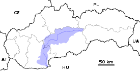  Current and watershed of the Hron River in Slovakia | |
| Location | |
| Country | Slovakia |
| Region | Banská Bystrica, Nitra |
| Physical characteristics | |
| Source | Hron |
| • location | Kráľova hoľa near Telgárt |
| • elevation | 980 m (3,220 ft) |
| Mouth | Danube |
• location | Kamenica nad Hronom, Nitra Region |
• elevation | 112 m (367 ft) |
| Length | 271 km (168 mi) |
| Basin size | 5,465 km2 (2,110 sq mi) |
| Discharge | |
| • average | 53.7 m3/s (1,900 cu ft/s) |
| • minimum | 7.6 m3/s (270 cu ft/s) |
| • maximum | 1,050 m3/s (37,000 cu ft/s) |
| Basin features | |
| Progression | Danube→ Black Sea |
| Tributaries | |
| • left | Slatina |
| • right | Zákruty |
Close
The river's basin covers 5,465 km2 (2,110 sq mi),[1] which is approximately 11 percent of Slovakia's territory.
Hron is a popular destination of water tourism.