
Hokkaido Koma-ga-take
Andesitic stratovolcano on the island of Hokkaido / From Wikipedia, the free encyclopedia
Hokkaidō Koma-ga-take (北海道駒ヶ岳, Hokkaidō Koma-ga-take), also Oshima Koma-ga-take (渡島駒ヶ岳), Oshima Fuji (渡島富士), or just Koma-ga-take (駒ヶ岳) is a 1,131 metres (3,711 ft) andesitic stratovolcano[1] on the border between Mori, Shikabe, and Nanae, all within the Oshima Subprefecture of Hokkaidō, Japan.
You can help expand this article with text translated from the corresponding article in Japanese. Click [show] for important translation instructions.
|
Quick Facts Mount Hokkaidō-Komagatake, Highest point ...
| Mount Hokkaidō-Komagatake | |
|---|---|
| 北海道駒ヶ岳 | |
 View from Lake Ōnuma (August 2008) | |
| Highest point | |
| Elevation | 1,131 m (3,711 ft) |
| Listing | List of mountains and hills of Japan by height List of volcanoes in Japan |
| Coordinates | 42°03′48″N 140°40′38″E |
| Naming | |
| Language of name | Japanese |
| Geography | |
| Topo map | Geographical Survey Institute 25000:1 駒ヶ岳 50000:1 室蘭 |
| Geology | |
| Age of rock | Quaternary |
| Mountain type | stratovolcano |
| Volcanic arc/belt | Northeastern Japan Arc |
| Last eruption | September to November 2000 |

Close
Occurrence of volcanic activity started some 30,000 years ago. Following roughly 5,000 years of dormancy, volcanic activity at Mount Koma-ga-take restarted in 1640,[2] triggering the Kan'ei Great Famine.[citation needed] Since then, there have been at least 50 recorded volcanic events at Mount Koma-ga-take.[3]
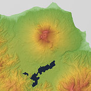 Relief Map
 Viewed from NW.
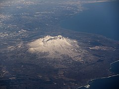 Viewed from ESE.


