Hales
Village in Norfolk, England From Wikipedia, the free encyclopedia
Village in Norfolk, England From Wikipedia, the free encyclopedia
Hales is a small village in Norfolk, England. It covers an area of 3.99 km2 (1.54 sq mi) and had a population of 479 in 192 households as of the 2001 census,[1] which had reduced to 469 at the 2011 census.[2]
| Hales | |
|---|---|
 | |
Location within Norfolk | |
| Area | 3.99 km2 (1.54 sq mi) |
| Population | 469 (2011) |
| • Density | 118/km2 (310/sq mi) |
| OS grid reference | TM382972 |
| Civil parish |
|
| District | |
| Shire county | |
| Region | |
| Country | England |
| Sovereign state | United Kingdom |
| Post town | NORWICH |
| Postcode district | NR14 |
| Police | Norfolk |
| Fire | Norfolk |
| Ambulance | East of England |

The village's name means 'Nooks of land'.
The manor of Hales dates back to the Domesday book. From the 11th century to the 17th century, Hales manor was held by the De Hales, later Hales, family.
Hales Hall was built in 1478 by Sir James Hobart, the Attorney General to Henry VII. He acquired the estate from Sir Roger de Hales whose daughter had married the Duke of Norfolk.[3] In 1666, the last Hales heiress was Lady Dionysia Williamson, who left her estate to her nephew John Hoskins.[4]
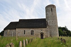
The Church of Hales St Margaret is one of 124 existing round-tower churches in Norfolk. With its thatched roof, this church probably comes closest to the original appearance of an early round-tower church. It is in care of the Churches Conservation Trust,[5] and is a Grade I listed building.[6]
The X2 bus service goes from Norwich in the west to Lowestoft in the east.[7]
The Pastures is a care home on Yarmouth Road.
Seamless Wikipedia browsing. On steroids.
Every time you click a link to Wikipedia, Wiktionary or Wikiquote in your browser's search results, it will show the modern Wikiwand interface.
Wikiwand extension is a five stars, simple, with minimum permission required to keep your browsing private, safe and transparent.