Gördes
District and municipality in Manisa, Turkey From Wikipedia, the free encyclopedia
District and municipality in Manisa, Turkey From Wikipedia, the free encyclopedia
Gördes is a municipality and district of Manisa Province, Turkey.[2] Its area is 902 km2,[3] and its population is 26,458 (2022).[1] The town lies at an elevation of 670 m (2,198 ft).
Gördes | |
|---|---|
District and municipality | |
 | |
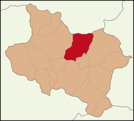
 Map showing Gördes District in Manisa Province | |
| Coordinates: 38°55′58″N 28°17′25″E | |
| Country | Turkey |
| Province | Manisa |
| Government | |
| • Mayor | Muhammet Akyol (AKP) |
| Area | 902 km2 (348 sq mi) |
| Elevation | 670 m (2,200 ft) |
| Population (2022)[1] | 26,458 |
| • Density | 29/km2 (76/sq mi) |
| Time zone | UTC+3 (TRT) |
| Postal code | 45750 |
| Area code | 0236 |
| Climate | Csa |
| Website | www |
Gördes has been held by the Persians, Macedonians, Roman and Byzantine empires, and in 1071AD passed to the Turks. From 1867 until 1922, Gördes was part of the Aidin Vilayet of the Ottoman Empire.
There are 64 neighbourhoods in Gördes District:[4]
Gördes is one of the handmade Turkish carpet production centers in Manisa. Gördes carpets have different pattern and styles. See: Ghiordes knot.
The main source of income is tobacco and poppy production and wheat, barley is grown. In recent years production of cherries, strawberries has begun production. Other crops include potatoes, peas, tomatoes and cucumbers and wine.
In addition, olive, quince and persimmon cultivation are also carried out in Gördes.[5]
The area has mining with Coal and Zeolite being the main deposits but kaolin, nickel-iron, titanium beds are also available. In addition, feldspar, marble, kyanite, chalcedony, Chromium, quartz and boron are among the minerals mined in the region.
Seamless Wikipedia browsing. On steroids.
Every time you click a link to Wikipedia, Wiktionary or Wikiquote in your browser's search results, it will show the modern Wikiwand interface.
Wikiwand extension is a five stars, simple, with minimum permission required to keep your browsing private, safe and transparent.