Loading AI tools
Mountain in North Carolina, US From Wikipedia, the free encyclopedia
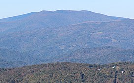
Grassy Ridge Bald is a bald mountain in North Carolina and is part of the Roan Highlands, within the Pisgah National Forest. Its elevation reaches 6,184 feet (1,885 m) and is on the boundary between Avery County, North Carolina (highest point) and Mitchell County, North Carolina. The mountain generates feeder streams for the North Toe River.[citation needed]
| Grassy Ridge Bald | |
|---|---|
 Grassy Ridge Bald viewed from Grandfather Mountain | |
| Highest point | |
| Elevation | 6,184 ft (1,885 m)[1] |
| Prominence | 688 ft (210 m)[2] |
| Parent peak | Roan High Knob[2] |
| Coordinates | 36°05′59″N 82°04′49″W[1] |
| Geography | |
 | |
| Location | Avery & Mitchell counties North Carolina, U.S. |
| Parent range | |
| Topo map | USGS Carvers Gap |
| Climbing | |
| Easiest route | Hike |
Seamless Wikipedia browsing. On steroids.
Every time you click a link to Wikipedia, Wiktionary or Wikiquote in your browser's search results, it will show the modern Wikiwand interface.
Wikiwand extension is a five stars, simple, with minimum permission required to keep your browsing private, safe and transparent.