Grabfeld, Thuringia
Municipality in Thuringia, Germany / From Wikipedia, the free encyclopedia
For the region rather than the political entity, see Grabfeld.
Grabfeld is a municipality in the district Schmalkalden-Meiningen, in Thuringia, Germany.
Quick Facts Country, State ...
Grabfeld | |
|---|---|
 Coat of arms | |
Location of Grabfeld within Schmalkalden-Meiningen district 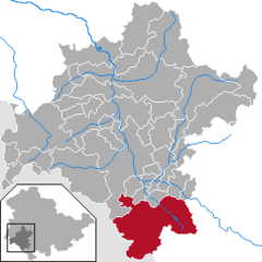 | |
 Grabfeld  Grabfeld | |
| Coordinates: 50°27′N 10°26′E | |
| Country | Germany |
| State | Thuringia |
| District | Schmalkalden-Meiningen |
| Subdivisions | 13 |
| Area | |
| • Total | 121.08 km2 (46.75 sq mi) |
| Elevation | 360 m (1,180 ft) |
| Population (2022-12-31)[1] | |
| • Total | 5,582 |
| • Density | 46/km2 (120/sq mi) |
| Time zone | UTC+01:00 (CET) |
| • Summer (DST) | UTC+02:00 (CEST) |
| Postal codes | 98631 |
| Dialling codes | 036944, 036947 |
| Vehicle registration | SM |
| Website | www |
Close

Grabfeld was established as a municipality on December 1, 2007 by combining the former municipalities of Behrungen, Berkach, Bibra, Exdorf, Jüchsen, Nordheim, Queienfeld, Rentwertshausen, Schwickershausen and Wolfmannshausen, replacing the former Verwaltungsgemeinschaft of the same name. It was joined by the former municipality Bauerbach in January 2012, and by Wölfershausen in January 2019.