Gobarralong
Town in New South Wales, Australia From Wikipedia, the free encyclopedia
Town in New South Wales, Australia From Wikipedia, the free encyclopedia
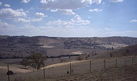
Gobarralong is a rural community in the central east part of the Riverina, Australia. It is situated about 16 kilometres southeast of Coolac and 27 kilometres northwest of Adjungbilly. At the 2016 census, Gobarralong and the surrounding area had a population of 52 people.[1]
| Gobarralong New South Wales | |
|---|---|
 Gobarralong Valley | |
| Coordinates | 35°2′8″S 148°19′28″E |
| Population | 52 (2016 census)[1] |
| Postcode(s) | 2727 |
| Elevation | 199 m (653 ft) |
| Location |
|
| LGA(s) | Cootamundra-Gundagai Regional Council |
| County | Buccleuch |
| State electorate(s) | Cootamundra |
| Federal division(s) | Riverina |
North Gobarralong Post Office opened on 1 November 1876, was renamed Gobarralong in 1909, and closed in 1967.[2]
Seamless Wikipedia browsing. On steroids.
Every time you click a link to Wikipedia, Wiktionary or Wikiquote in your browser's search results, it will show the modern Wikiwand interface.
Wikiwand extension is a five stars, simple, with minimum permission required to keep your browsing private, safe and transparent.