Gnarrenburg
Municipality in Lower Saxony, Germany From Wikipedia, the free encyclopedia
Municipality in Lower Saxony, Germany From Wikipedia, the free encyclopedia
Gnarrenburg is a municipality in the district of Rotenburg, in Lower Saxony, Germany. It is situated approximately 15 km southwest of Bremervörde, and 40 km northeast of Bremen.
Gnarrenburg | |
|---|---|
 Flag  Coat of arms | |
Location of Gnarrenburg within Rotenburg (Wümme) district 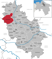 | |
 Gnarrenburg  Gnarrenburg | |
| Coordinates: 53°23′11″N 09°00′18″E | |
| Country | Germany |
| State | Lower Saxony |
| District | Rotenburg (Wümme) |
| Subdivisions | 12 districts |
| Government | |
| • Mayor (2021–26) | Marc Breitenfeld[1] (CDU) |
| Area | |
| • Total | 122.91 km2 (47.46 sq mi) |
| Elevation | 10 m (30 ft) |
| Population (2022-12-31)[2] | |
| • Total | 9,205 |
| • Density | 75/km2 (190/sq mi) |
| Time zone | UTC+01:00 (CET) |
| • Summer (DST) | UTC+02:00 (CEST) |
| Postal codes | 27442 |
| Dialling codes | 04763 |
| Vehicle registration | ROW |
| Website | www.gnarrenburg.de |
.jpg)
Gnarrenburg belonged to the Prince-Archbishopric of Bremen. In 1648 the Prince-Archbishopric was transformed into the Duchy of Bremen, which was first ruled in personal union by the Swedish and from 1715 on by the Hanoverian Crown. In 1823 the Duchy was abolished and its territory became part of the Stade Region.
Seamless Wikipedia browsing. On steroids.
Every time you click a link to Wikipedia, Wiktionary or Wikiquote in your browser's search results, it will show the modern Wikiwand interface.
Wikiwand extension is a five stars, simple, with minimum permission required to keep your browsing private, safe and transparent.
