
Frohnleiten
Place in Styria, Austria / From Wikipedia, the free encyclopedia
Dear Wikiwand AI, let's keep it short by simply answering these key questions:
Can you list the top facts and stats about Frohnleiten?
Summarize this article for a 10 year old
SHOW ALL QUESTIONS
Frohnleiten (German: [fʁonˈlaɪ̯tn̩]) is a town in the district of Graz-Umgebung in the Austrian state of Styria.
 Town Hall of Frohnleiten
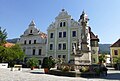 Baroque gables at the main square of Frohnleiten
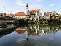 View of the old town center from a bridge over the river Mur


This article may require cleanup to meet Wikipedia's quality standards. The specific problem is: Images and format might need reorganizing. (April 2022) |
Quick Facts Country, State ...
Frohnleiten | |
|---|---|
 | |
 Coat of arms | |
 Location within Graz-Umgebung district | |
 Frohnleiten Location within Austria | |
| Coordinates: 47°16′13″N 15°19′28″E | |
| Country | Austria |
| State | Styria |
| District | Graz-Umgebung |
| Government | |
| • Mayor | Johannes Wagner (ÖVP) |
| Area | |
| • Total | 153.91 km2 (59.42 sq mi) |
| Elevation | 438 m (1,437 ft) |
| Population (2018-01-01)[2] | |
| • Total | 6,655 |
| • Density | 43/km2 (110/sq mi) |
| Time zone | UTC+1 (CET) |
| • Summer (DST) | UTC+2 (CEST) |
| Postal code | 8130 |
| Area code | 03126 |
| Vehicle registration | GU |
| Website | www.frohnleiten.org |
Close