File:View_of_Cappadocia_edit.jpg
From Wikipedia, the free encyclopedia
Size of this preview: 800 × 526 pixels. Other resolutions: 320 × 211 pixels | 640 × 421 pixels | 1,024 × 674 pixels | 1,514 × 996 pixels.
Original file (1,514 × 996 pixels, file size: 1.17 MB, MIME type: image/jpeg)
| This is a file from the Wikimedia Commons. Information from its description page there is shown below. Commons is a freely licensed media file repository. You can help. |
| This is a featured picture, which means that members of the community have identified it as one of the finest images on the English Wikipedia, adding significantly to its accompanying article. If you have a different image of similar quality, be sure to upload it using the proper free license tag, add it to a relevant article, and nominate it. |
| This image was selected as picture of the day on the English Wikipedia for March 3, 2008. |
Summary
|
| DescriptionView of Cappadocia edit.jpg |
العربية: قباذق (كبادوكيا)، هي منطقة تقع في وسط تُركيا، وتشتهرُ بِمُنتزه غوريم الوطني، الذي أُضيف إلى قائمة مواقع التراث العالمي التابعة لليُونيسكو سنة 1985. تُشيرُ الأدلَّة الأثريَّة إلى أنَّ أقدم استيطانٍ بشريٍّ للمنطقة يرجع إلى العصر الروماني وتحديدًا إلى بدايات العهد المسيحي. تشتهرُ المنطقة كذلك بتشكيلاتها الصخريَّة الفريدة التي يُطلق عليها عُلماء طبقات الأرض "المداخن الطبيعيَّة"، والتي يصلُ ارتفاع بعضها إلى 40 متر (130 قدم). خلال آلاف السنين، نحتت الرياح والأمطار عدَّة طبقات من الرماد البُركاني المُقسَّى، أو الطفة، حتَّى تشكَّل هذا المنظر الطبيعي المُتموِّج. خلال الفترة المُمتدَّة من القرن الرابع حتَّى القرن الثالث عشر الميلاديّ، قام أهالي المنطقة بِحفر أنفاقٍ في أسطح الصُخور المكشوفة في سبيل تشييد مساكن، ومتاجر، وكنائس يأوون إليها، شكَّلت كُلها إحدى روائع العمارة البيزنطيَّة. يزُورُ هذا الموقع أكثر من 500,000 سائح خلال السنة.
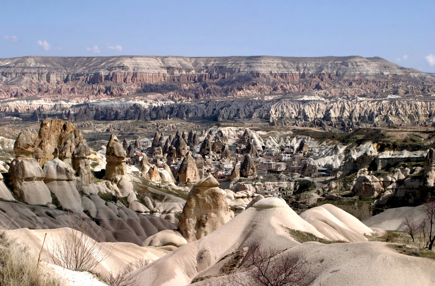
English: Cappadocia, a region in central Turkey, is known for its Göreme National Park, which was added to the UNESCO World Heritage List in 1985.The first period of settlement within the region reaches to Roman period of Christian era. The area is also famous for its fairy chimneys rock formations, some of which reach 40 meters (130 feet) in height. Over thousands of years, wind and rain eroded layers of consolidated volcanic ash, or tuff, to form the sweeping landscape. From the 4th to 13th century AD, occupants of the area dug tunnels into the exposed rock face to build residences, stores, and churches which are home to irreplaceable Byzantine art. More than 500,000 tourists visit the region each year.
Türkçe: Kapadokya'dan bir manzara (Göreme, Türkiye) |
| Date | |
| Source | Own work |
| Author | Brocken Inaglory Edit by CillanXC |
Licensing
I, the copyright holder of this work, hereby publish it under the following licenses:

|
Permission is granted to copy, distribute and/or modify this document under the terms of the GNU Free Documentation License, Version 1.2 or any later version published by the Free Software Foundation; with no Invariant Sections, no Front-Cover Texts, and no Back-Cover Texts. A copy of the license is included in the section entitled GNU Free Documentation License.http://www.gnu.org/copyleft/fdl.htmlGFDLGNU Free Documentation Licensetruetrue |
| This file is licensed under the Creative Commons Attribution-Share Alike 3.0 Unported license. | ||
| ||
| This licensing tag was added to this file as part of the GFDL licensing update.http://creativecommons.org/licenses/by-sa/3.0/CC BY-SA 3.0Creative Commons Attribution-Share Alike 3.0truetrue |
This file is licensed under the Creative Commons Attribution-Share Alike 2.5 Generic, 2.0 Generic and 1.0 Generic license.
- You are free:
- to share – to copy, distribute and transmit the work
- to remix – to adapt the work
- Under the following conditions:
- attribution – You must give appropriate credit, provide a link to the license, and indicate if changes were made. You may do so in any reasonable manner, but not in any way that suggests the licensor endorses you or your use.
- share alike – If you remix, transform, or build upon the material, you must distribute your contributions under the same or compatible license as the original.
You may select the license of your choice.
Captions
Add a one-line explanation of what this file represents
Items portrayed in this file
depicts
March 2006
File history
Click on a date/time to view the file as it appeared at that time.
| Date/Time | Thumbnail | Dimensions | User | Comment | |
|---|---|---|---|---|---|
| current | 15:17, 25 October 2007 | | 1,514 × 996 (1.17 MB) | CillanXC | Edit for WP:FPC. ==Licensing== {{self|GFDL|cc-by-sa-2.5,2.0,1.0}} |
File usage
The following pages on the English Wikipedia use this file (pages on other projects are not listed):
- Geology of Turkey
- List of World Heritage Sites in Turkey
- List of national parks of Turkey
- Lists of national parks
- Maslama ibn Hisham
- Runfire Cappadocia Ultramarathon
- User:CillanXC
- User:CillanXC/archive
- User:Mauriziok/List of national parks
- Wikipedia:Featured picture candidates/October-2007
- Wikipedia:Featured picture candidates/View of Cappadocia edit.jpg
- Wikipedia:Featured pictures/Places/Landscapes
- Wikipedia:Featured pictures thumbs/08
- Wikipedia:Picture of the day/March 2008
- Wikipedia:WikiProject Turkey/Recognized content
- Wikipedia:WikiProject Turkey/StatusArticleList
- Wikipedia:WikiProject Volcanoes/Content
- Wikipedia:Wikipedia Signpost/2007-11-05/Features and admins
- Wikipedia:Wikipedia Signpost/2007-11-05/SPV
- Wikipedia:Wikipedia Signpost/Single/2007-11-05
- Template:POTD/2008-03-03
Global file usage
The following other wikis use this file:
- Usage on als.wikipedia.org
- Usage on ar.wikipedia.org
- قائمة مواقع التراث العالمي في أوروبا
- ويكيبيديا:صور مختارة/أماكن/مناظر طبيعية
- ويكيبيديا:ترشيحات الصور المختارة/قباذق
- ويكيبيديا:صورة اليوم المختارة/يونيو 2016
- قالب:صورة اليوم المختارة/2016-06-23
- ويكيبيديا:صورة اليوم المختارة/أكتوبر 2017
- قالب:صورة اليوم المختارة/2017-10-15
- ويكيبيديا:صورة اليوم المختارة/سبتمبر 2019
- قالب:صورة اليوم المختارة/2019-09-07
- مستخدم:12lama/ملعب
- ويكيبيديا:صورة اليوم المختارة/أغسطس 2022
- قالب:صورة اليوم المختارة/2022-08-24
- Usage on arz.wikipedia.org
- Usage on az.wikipedia.org
- Usage on bg.wikipedia.org
- Usage on bs.wikipedia.org
- Usage on cy.wikipedia.org
- Usage on el.wikipedia.org
- Usage on en.wiktionary.org
- Usage on eo.wikipedia.org
- Usage on es.wikipedia.org
- Usage on eu.wikipedia.org
- Usage on fa.wikipedia.org
- Usage on fi.wikipedia.org
- Usage on fr.wikipedia.org
- Usage on he.wikipedia.org
- Usage on hr.wikipedia.org
- Usage on id.wikipedia.org
- Usage on is.wikipedia.org
- Usage on it.wikipedia.org
- Usage on ku.wikipedia.org
- Usage on lld.wikipedia.org
- Usage on mk.wikipedia.org
- Usage on ml.wikipedia.org
- Usage on mt.wikipedia.org
- Usage on nl.wikipedia.org
View more global usage of this file.
Metadata
This file contains additional information, probably added from the digital camera or scanner used to create or digitize it.
If the file has been modified from its original state, some details may not fully reflect the modified file.
| Orientation | Normal |
|---|---|
| Horizontal resolution | 150 dpi |
| Vertical resolution | 150 dpi |
| Software used | Adobe Photoshop 7.0 |
| File change date and time | 11:15, 25 October 2007 |
| Color space | Uncalibrated |