File:Tatry_Mapa_Plastyczna.JPG
From Wikipedia, the free encyclopedia
No higher resolution available.
Tatry_Mapa_Plastyczna.JPG (700 × 525 pixels, file size: 206 KB, MIME type: image/jpeg)
| This is a file from the Wikimedia Commons. Information from its description page there is shown below. Commons is a freely licensed media file repository. You can help. |
Summary
| DescriptionTatry Mapa Plastyczna.JPG |
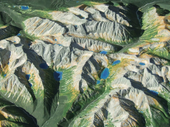
Polski: Mapa Plastyczna Tatr w skali 1:50 000 wyrzeźbiona w gipsie. Autorem rzeźby jest Jerzy Zasadni |
| Date | 27 November 2007 (original upload date) |
| Source | Transferred from pl.wikipedia to Commons by Marcello002. |
| Author | Jerzas at Polish Wikipedia |
Licensing
Jerzas at Polish Wikipedia, the copyright holder of this work, hereby publishes it under the following licenses:

|
Permission is granted to copy, distribute and/or modify this document under the terms of the GNU Free Documentation License, Version 1.2 or any later version published by the Free Software Foundation; with no Invariant Sections, no Front-Cover Texts, and no Back-Cover Texts. A copy of the license is included in the section entitled GNU Free Documentation License.http://www.gnu.org/copyleft/fdl.htmlGFDLGNU Free Documentation Licensetruetrue |
This file is licensed under the Creative Commons Attribution 3.0 Unported license.
Attribution: Jerzas at Polish Wikipedia
- You are free:
- to share – to copy, distribute and transmit the work
- to remix – to adapt the work
- Under the following conditions:
- attribution – You must give appropriate credit, provide a link to the license, and indicate if changes were made. You may do so in any reasonable manner, but not in any way that suggests the licensor endorses you or your use.
You may select the license of your choice.
Original upload log
The original description page was here. All following user names refer to pl.wikipedia.
- 2007-11-27 08:40 Jerzas 700×525× (210550 bytes) Mapa Plastyczna Tatr w skali 1:50 000 wyrzeźbiona w gipsie. Skala pionowa nie jest przewyższona (także 1:50 000). Odległość w pionie między taflą Morskiego Oka a szczytami Mieguszowieckimi to tylko 2 cm. Autorem mapy jest Jerzy Zasadni. Na zdjęci
- 2007-11-27 06:44 Jerzas 1600×1200× (388111 bytes) Mapa Plastyczna Tatr w skali 1:50 000 wyrzeźbiona w gipsie. Skala pionowa nie jest przewyższona (także 1:50 000)
Captions
Add a one-line explanation of what this file represents
Items portrayed in this file
depicts
27 November 2007
0.00090909090909090909 second
3.4
10 millimetre
image/jpeg
File history
Click on a date/time to view the file as it appeared at that time.
| Date/Time | Thumbnail | Dimensions | User | Comment | |
|---|---|---|---|---|---|
| current | 14:29, 6 December 2009 | | 700 × 525 (206 KB) | Marcello002 | {{Information |Description={{pl|Mapa Plastyczna Tatr w skali 1:50 000 wyrzeźbiona w gipsie}} |Source=Transferred from [http://pl.wikipedia.org pl.wikipedia]; transfer was stated to be made by User:Marcello002. |Date={{Date|2007|11|27}} (first version |
File usage
The following pages on the English Wikipedia use this file (pages on other projects are not listed):
Global file usage
The following other wikis use this file:
- Usage on ar.wikipedia.org
- Usage on csb.wikipedia.org
- Usage on cs.wikipedia.org
- Usage on de.wikipedia.org
- Usage on de.wikivoyage.org
- Usage on eo.wikipedia.org
- Usage on es.wikipedia.org
- Usage on fa.wikipedia.org
- Usage on id.wikipedia.org
- Usage on pl.wikipedia.org
- Usage on pt.wikipedia.org
- Usage on sk.wikipedia.org
- Usage on uk.wikipedia.org
- Usage on www.wikidata.org
Metadata
This file contains additional information, probably added from the digital camera or scanner used to create or digitize it.
If the file has been modified from its original state, some details may not fully reflect the modified file.
| Camera manufacturer | FUJIFILM |
|---|---|
| Camera model | FinePix S9500 |
| Author | Picasa 2.0 |
| Exposure time | 1/1,100 sec (0.00090909090909091) |
| F-number | f/3.4 |
| ISO speed rating | 80 |
| Date and time of data generation | 05:39, 6 July 2006 |
| Lens focal length | 10 mm |
| Orientation | Normal |
| Horizontal resolution | 72 dpi |
| Vertical resolution | 72 dpi |
| Software used | Adobe Photoshop 7.0 |
| File change date and time | 09:38, 27 November 2007 |
| Y and C positioning | Co-sited |
| Exposure Program | Aperture priority |
| Exif version | 2.2 |
| Date and time of digitizing | 05:39, 6 July 2006 |
| Meaning of each component |
|
| Image compression mode | 4 |
| Shutter speed | −0.0998828125 |
| APEX aperture | 3.5 |
| APEX brightness | −0.6598828125 |
| Exposure bias | 0 |
| Maximum land aperture | 3 APEX (f/2.83) |
| Metering mode | Pattern |
| Light source | Unknown |
| Flash | Flash did not fire, compulsory flash suppression |
| Supported Flashpix version | 1 |
| Color space | Uncalibrated |
| Focal plane X resolution | 8,967 |
| Focal plane Y resolution | 8,967 |
| Focal plane resolution unit | 3 |
| Sensing method | One-chip color area sensor |
| File source | Digital still camera |
| Scene type | A directly photographed image |
| Custom image processing | Normal process |
| Exposure mode | Auto exposure |
| White balance | Auto white balance |
| Scene capture type | Standard |
| Contrast | Normal |
| Saturation | Normal |
| Sharpness | Normal |
| Subject distance range | Unknown |
| Unique image ID | da4424300b8a2882d16530918205ef99 |
| IIM version | 2 |
| Contact information | <picasastamp/> |
Retrieved from "https://en.wikipedia.org/wiki/File:Tatry_Mapa_Plastyczna.JPG"