File:South_Africa_Districts_April_2006.png
From Wikipedia, the free encyclopedia
Size of this preview: 800 × 581 pixels. Other resolutions: 320 × 232 pixels | 640 × 464 pixels | 1,024 × 743 pixels | 1,141 × 828 pixels.
Original file (1,141 × 828 pixels, file size: 38 KB, MIME type: image/png)
| This is a file from the Wikimedia Commons. Information from its description page there is shown below. Commons is a freely licensed media file repository. You can help. |

|
This locator map image could be re-created using vector graphics as an SVG file. This has several advantages; see Commons:Media for cleanup for more information. If an SVG form of this image is available, please upload it and afterwards replace this template with
{{vector version available|new image name}}.
It is recommended to name the SVG file “South Africa Districts April 2006.svg”—then the template Vector version available (or Vva) does not need the new image name parameter. |
Summary
| DescriptionSouth Africa Districts April 2006.png |
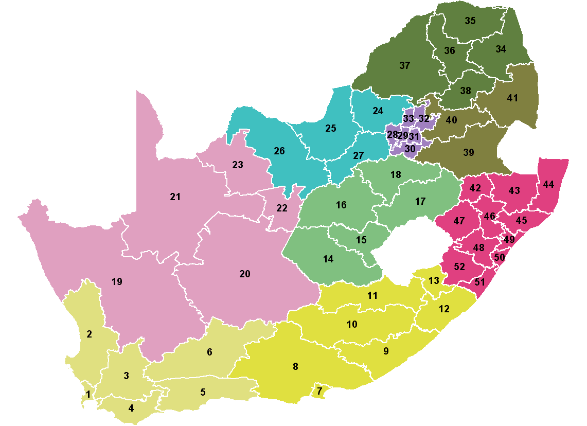
Map showing the 52 districts of South Africa. Colours indicate the 9 provinces. Created by Wayne Dam using data from the Municipal Demarcation Board after the 12th amendment to the Constitution. |
| Date | |
| Source | Created by me from Shapefile data from the Municipal Demarcation Board, South Africa. |
| Author | Wayne Dam (User:Waynedam) |
| Permission (Reusing this file) |
Dual-licensed under the GFDL and CC-By-SA-2.5, 2.0, and 1.0. |
Licensing
I, the copyright holder of this work, hereby publish it under the following licenses:

|
Permission is granted to copy, distribute and/or modify this document under the terms of the GNU Free Documentation License, Version 1.2 or any later version published by the Free Software Foundation; with no Invariant Sections, no Front-Cover Texts, and no Back-Cover Texts. A copy of the license is included in the section entitled GNU Free Documentation License.http://www.gnu.org/copyleft/fdl.htmlGFDLGNU Free Documentation Licensetruetrue |
| This file is licensed under the Creative Commons Attribution-Share Alike 3.0 Unported license. | ||
| ||
| This licensing tag was added to this file as part of the GFDL licensing update.http://creativecommons.org/licenses/by-sa/3.0/CC BY-SA 3.0Creative Commons Attribution-Share Alike 3.0truetrue |
This file is licensed under the Creative Commons Attribution-Share Alike 2.5 Generic, 2.0 Generic and 1.0 Generic license.
- You are free:
- to share – to copy, distribute and transmit the work
- to remix – to adapt the work
- Under the following conditions:
- attribution – You must give appropriate credit, provide a link to the license, and indicate if changes were made. You may do so in any reasonable manner, but not in any way that suggests the licensor endorses you or your use.
- share alike – If you remix, transform, or build upon the material, you must distribute your contributions under the same or compatible license as the original.
You may select the license of your choice.
Captions
Add a one-line explanation of what this file represents
Mapa das 9 provincias e 52 distritos de Suráfrica a partir da décimo segunda emenda da Constitución.
Items portrayed in this file
depicts
23 April 2006
File history
Click on a date/time to view the file as it appeared at that time.
| Date/Time | Thumbnail | Dimensions | User | Comment | |
|---|---|---|---|---|---|
| current | 21:04, 15 April 2006 | | 1,141 × 828 (38 KB) | Waynedam | Map showing the 52 districts of South Africa. Colours indicate the 9 provinces. Created by Wayne Dam using data from the Municipal Demarcation Board after the 12th amendment to the Constitution. |
File usage
The following pages on the English Wikipedia use this file (pages on other projects are not listed):
Global file usage
The following other wikis use this file:
- Usage on als.wikipedia.org
- Usage on bar.wikipedia.org
- Usage on bg.wikipedia.org
- Usage on ca.wikipedia.org
- Usage on dsb.wikipedia.org
- Usage on eo.wikipedia.org
- Usage on fi.wikipedia.org
- Usage on frr.wikipedia.org
- Usage on gl.wikipedia.org
- Usage on hu.wikipedia.org
- Usage on id.wikipedia.org
- Usage on it.wikipedia.org
- Usage on ja.wikipedia.org
- Usage on lt.wikipedia.org
- Usage on mr.wikipedia.org
- Usage on nl.wikipedia.org
- Usage on nov.wikipedia.org
- Usage on pl.wikipedia.org
- Usage on pt.wikipedia.org
- Usage on rm.wikipedia.org
- Usage on ro.wikipedia.org
- Usage on sw.wikipedia.org
- Usage on tn.wikipedia.org
- Usage on tr.wikipedia.org