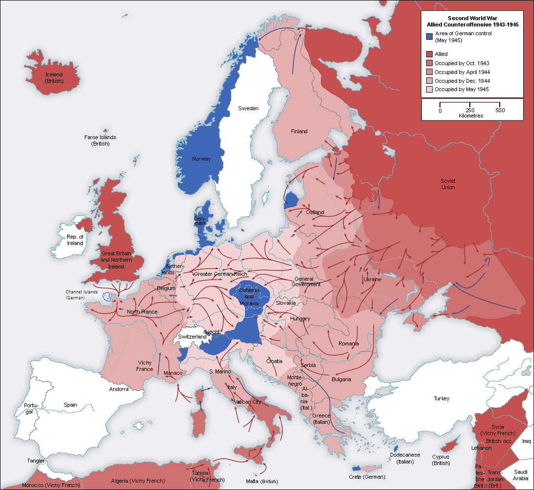
File:Second_world_war_europe_1943-1945_map_en.png
From Wikipedia, the free encyclopedia
Size of this preview: 654 × 600 pixels. Other resolutions: 262 × 240 pixels | 523 × 480 pixels | 837 × 768 pixels | 1,090 × 1,000 pixels.
Original file (1,090 × 1,000 pixels, file size: 264 KB, MIME type: image/png)
| This is a file from the Wikimedia Commons. Information from its description page there is shown below. Commons is a freely licensed media file repository. You can help. |
I, the copyright holder of this work, hereby publish it under the following licenses:
| This file is licensed under the Creative Commons Attribution-Share Alike 3.0 Unported license. | ||
| ||
| This licensing tag was added to this file as part of the GFDL licensing update.http://creativecommons.org/licenses/by-sa/3.0/CC BY-SA 3.0Creative Commons Attribution-Share Alike 3.0truetrue |

|
Permission is granted to copy, distribute and/or modify this document under the terms of the GNU Free Documentation License, Version 1.2 or any later version published by the Free Software Foundation; with no Invariant Sections, no Front-Cover Texts, and no Back-Cover Texts. A copy of the license is included in the section entitled GNU Free Documentation License.http://www.gnu.org/copyleft/fdl.htmlGFDLGNU Free Documentation Licensetruetrue |
You may select the license of your choice.
Original upload log
This image is a derivative work of the following images:
- File:Second_world_war_europe_1943-1945_map_de.png licensed with Cc-by-sa-3.0-migrated, GFDL
- 2005-08-22T13:32:49Z Rony 1090x1000 (199724 Bytes)
Uploaded with derivativeFX
Captions
Add a one-line explanation of what this file represents
Items portrayed in this file
depicts
21 August 2010
File history
Click on a date/time to view the file as it appeared at that time.
| Date/Time | Thumbnail | Dimensions | User | Comment | |
|---|---|---|---|---|---|
| current | 22:51, 24 October 2021 | | 1,090 × 1,000 (264 KB) | Rebelbear | Reverted to version as of 22:20, 24 October 2021 (UTC) |
| 22:43, 24 October 2021 |  | 1,090 × 1,000 (130 KB) | Rebelbear | Interestingly enough, the Channel Islands were still under German occupation at the end of the war (sorry, first upload did not work) | |
| 22:20, 24 October 2021 |  | 1,090 × 1,000 (264 KB) | Rebelbear | Interestingly enough, the Channel Islands were still under German occupation at the end of the war | |
| 17:24, 20 November 2019 |  | 1,090 × 1,000 (115 KB) | Claude Zygiel | Cosmetic (differenciate shorelines, borders, demarcation lines) | |
| 05:46, 2 December 2015 |  | 1,090 × 1,000 (108 KB) | Rhadamante | I don't know if there is a problem for color blinds with this version, but hte current one is totally unreadable | |
| 17:18, 22 May 2012 |  | 1,088 × 998 (286 KB) | DIREKTOR | Colours | |
| 10:46, 21 August 2010 |  | 1,090 × 1,000 (108 KB) | Jarry1250 | {{Information |Description=* Description: Second world war europe 1943-1945, map , relabelled into English * Original source: Own map, based on the maps of the [http://www.lib.utexas.edu/maps/ University of Texas Libraries] * Original author: [[User:San |
File usage
The following pages on the English Wikipedia use this file (pages on other projects are not listed):
Global file usage
The following other wikis use this file:
- Usage on ar.wikipedia.org
- Usage on be.wikipedia.org
- Usage on bg.wikipedia.org
- Usage on ca.wikipedia.org
- Usage on cs.wikipedia.org
- Usage on es.wikipedia.org
- Usage on eu.wikipedia.org
- Usage on fa.wikipedia.org
- Usage on fi.wikipedia.org
- Usage on fr.wikipedia.org
- Usage on fy.wikipedia.org
- Usage on ja.wikipedia.org
- Usage on ko.wikipedia.org
- Usage on no.wikipedia.org
- Usage on pnb.wikipedia.org
- Usage on pt.wikipedia.org
- Usage on ru.wikipedia.org
- Usage on sv.wikipedia.org
- Usage on ta.wikipedia.org
- Usage on tr.wikipedia.org
- Usage on uk.wikipedia.org
- Usage on ur.wikipedia.org
Metadata
This file contains additional information, probably added from the digital camera or scanner used to create or digitize it.
If the file has been modified from its original state, some details may not fully reflect the modified file.
| Horizontal resolution | 28.35 dpc |
|---|---|
| Vertical resolution | 28.35 dpc |