File:Railway_Map_of_Kazakhstan_(kk).png
From Wikipedia, the free encyclopedia
Size of this preview: 800 × 457 pixels. Other resolutions: 320 × 183 pixels | 640 × 366 pixels | 1,024 × 585 pixels | 1,280 × 731 pixels | 2,560 × 1,463 pixels | 4,134 × 2,362 pixels.
Original file (4,134 × 2,362 pixels, file size: 1.49 MB, MIME type: image/png)
| This is a file from the Wikimedia Commons. Information from its description page there is shown below. Commons is a freely licensed media file repository. You can help. |
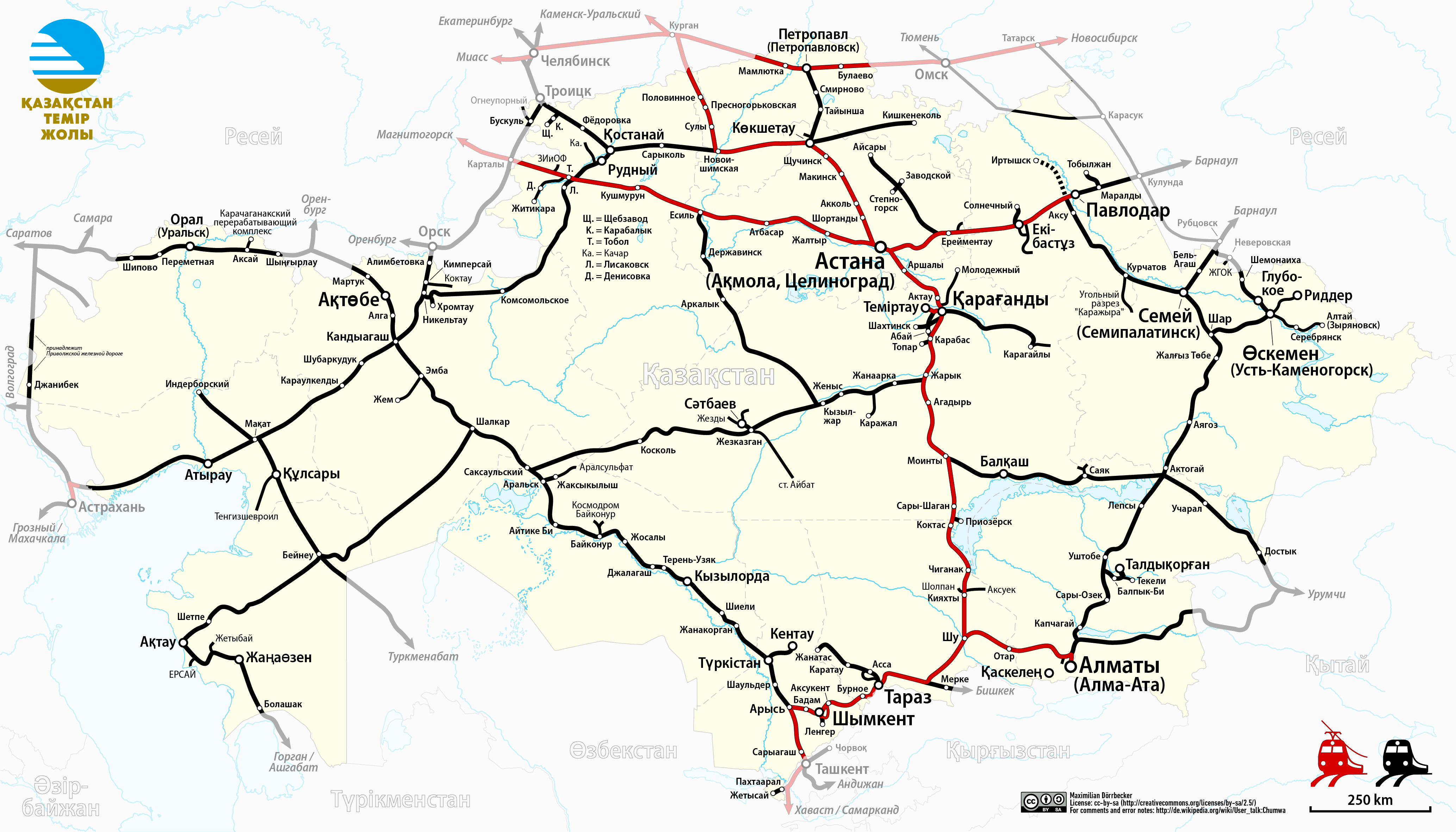
| DescriptionRailway Map of Kazakhstan (kk).png |
|
| Date | see file history |
| Source |
Own work, using
|
| Author | Maximilian Dörrbecker (Chumwa) |
| Permission (Reusing this file) |
I, the copyright holder of this work, hereby publish it under the following license: This file is licensed under the Creative Commons Attribution-Share Alike 2.5 Generic license.
Sie dürfen das Bild zu den folgenden Bedingungen nutzen:
|
Captions
Kazakhstan Railway Network
Items portrayed in this file
depicts
image/png
File history
Click on a date/time to view the file as it appeared at that time.
| Date/Time | Thumbnail | Dimensions | User | Comment | |
|---|---|---|---|---|---|
| current | 20:43, 9 June 2024 | | 4,134 × 2,362 (1.49 MB) | Looklike03 | Reverted to version as of 21:59, 19 March 2019 (UTC), because Nur-Sultan now is Astana |
| 20:41, 9 June 2024 |  | 4,134 × 2,362 (1.49 MB) | Looklike03 | Reverted to version as of 22:45, 27 February 2019 (UTC) | |
| 21:47, 25 March 2019 |  | 4,134 × 2,362 (1.49 MB) | Chumwa | update | |
| 18:39, 25 March 2019 |  | 4,134 × 2,362 (1.49 MB) | Chumwa | corr | |
| 21:59, 19 March 2019 |  | 4,134 × 2,362 (1.49 MB) | Chumwa | Zyryanovsk now is Altai | |
| 22:45, 27 February 2019 |  | 4,134 × 2,362 (1.49 MB) | Chumwa | The western line (two segments near Dzhanibek) belongs to the Volga railway | |
| 06:16, 15 August 2017 |  | 4,134 × 2,362 (1.48 MB) | Chumwa | ||
| 04:28, 14 August 2017 |  | 4,134 × 2,362 (1.5 MB) | Chumwa | ||
| 20:05, 13 August 2017 |  | 4,134 × 2,362 (1.49 MB) | Chumwa | ||
| 19:38, 13 August 2017 |  | 4,134 × 2,362 (1.49 MB) | Chumwa | {{Information |Description= *{{de|Eisenbahnkarte von Kasachstan}} *{{en|Railway map of Kazakhstan}} |Source={{Own}}, using * this file by {{U|NordNordWest}} as background * [[:File:Kazakhstan Temir Zholy Logo.svg|L... |
File usage
The following pages on the English Wikipedia use this file (pages on other projects are not listed):
Global file usage
The following other wikis use this file:
- Usage on ar.wikipedia.org
- Usage on az.wikipedia.org
- Usage on ba.wikipedia.org
- Usage on be.wikipedia.org
- Usage on de.wikipedia.org
- Usage on de.wikivoyage.org
- Usage on en.wikivoyage.org
- Usage on eo.wikipedia.org
- Usage on es.wikipedia.org
- Usage on et.wikipedia.org
- Usage on fr.wikipedia.org
- Usage on fr.wikivoyage.org
- Usage on he.wikipedia.org
- Usage on hu.wikipedia.org
- Usage on it.wikipedia.org
- Usage on it.wikivoyage.org
- Usage on ja.wikipedia.org
- Usage on kk.wikipedia.org
- Usage on ko.wikipedia.org
- Usage on mk.wikipedia.org
- Usage on no.wikipedia.org
- Usage on pl.wikipedia.org
- Usage on ro.wikipedia.org
- Usage on ru.wikipedia.org
- Usage on sr.wikipedia.org
- Usage on sv.wikipedia.org
- Usage on tr.wikipedia.org
- Usage on tt.wikipedia.org
- Usage on uk.wikipedia.org
- Usage on www.wikidata.org
- Usage on zh.wikipedia.org
Metadata
This file contains additional information, probably added from the digital camera or scanner used to create or digitize it.
If the file has been modified from its original state, some details may not fully reflect the modified file.
| Horizontal resolution | 59.06 dpc |
|---|---|
| Vertical resolution | 59.06 dpc |
| Software used |
.png)