File:Oshima-Oshima_island_aerial_photograph.JPG
From Wikipedia, the free encyclopedia
Size of this preview: 800 × 592 pixels. Other resolutions: 320 × 237 pixels | 640 × 474 pixels | 1,024 × 758 pixels | 1,280 × 948 pixels | 2,560 × 1,895 pixels | 4,760 × 3,524 pixels.
Original file (4,760 × 3,524 pixels, file size: 9.72 MB, MIME type: image/jpeg)
| This is a file from the Wikimedia Commons. Information from its description page there is shown below. Commons is a freely licensed media file repository. You can help. |
Summary
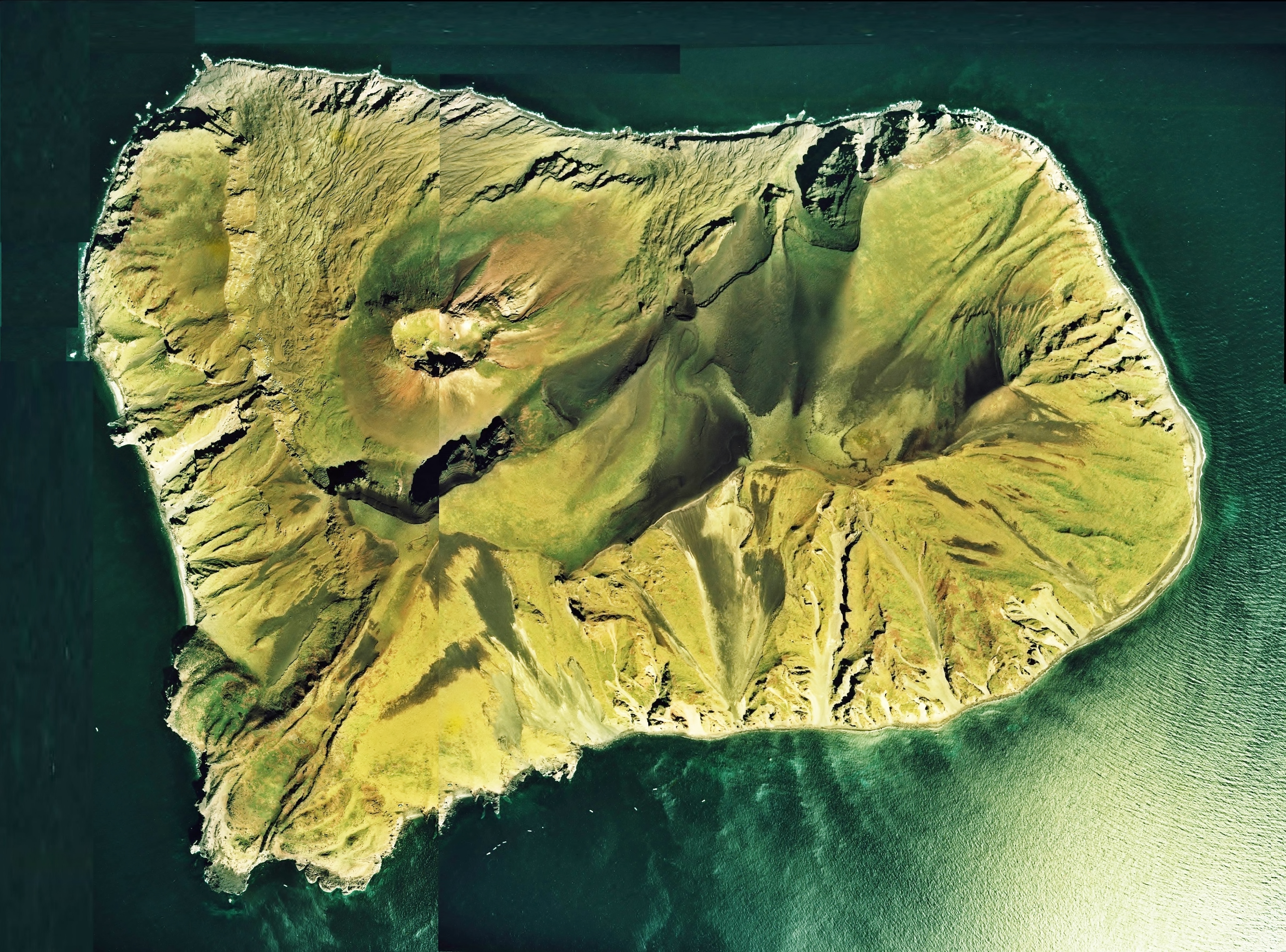
| DescriptionOshima-Oshima island aerial photograph.JPG |
English: Oshima-Oshima island aerial photograph
日本語: 渡島大島(北海道松前町)の空中写真。Cho-76-18_c26_2を使用。 |
| Date | |
| Source | 国土情報ウェブマッピングシステム |
| Author | 国土交通省 |
Licensing

|
The copyright holder of this file, the Ministry of Land, Infrastructure, Transport and Tourism of Japan, allows anyone to use it for any purpose, provided that the copyright holder is properly attributed. Redistribution, derivative work, commercial use, and all other use is permitted. |
Attribution:
Copyright © National Land Image Information (Color Aerial Photographs), Ministry of Land, Infrastructure, Transport and Tourism Attribution |
 |
This image is copyrighted by the Ministry of Land, Infrastructure, Transport and Tourism of Japan. For terms of use, see the stipulation to use of National Land Information (in Japanese) and message from MLIT (in Japanese and English). When you display this image on an article, include the following phrase in the description: "Made based on National Land Image Information (Color Aerial Photographs), Ministry of Land, Infrastructure, Transport and Tourism".
|
Captions
Add a one-line explanation of what this file represents
Items portrayed in this file
depicts
File history
Click on a date/time to view the file as it appeared at that time.
| Date/Time | Thumbnail | Dimensions | User | Comment | |
|---|---|---|---|---|---|
| current | 06:58, 8 September 2013 | | 4,760 × 3,524 (9.72 MB) | さかおり | Re-create the image of the whole island |
| 04:34, 11 December 2010 |  | 3,495 × 3,283 (7.38 MB) | さかおり | {{Information |Description={{en|1=Oshima-Oshima island aerial photograph}} {{ja|1=渡島大島(北海道松前町)の空中写真。Cho-76-18_c26_2を使用。}} |Source=国土情報ウェブマッピングシステム |Author=国土交通省 |Date=19 |
File usage
The following pages on the English Wikipedia use this file (pages on other projects are not listed):
Global file usage
The following other wikis use this file:
- Usage on de.wikipedia.org
- Usage on es.wikipedia.org
- Usage on id.wikipedia.org
- Usage on ja.wikipedia.org
- Usage on ko.wikipedia.org
- Usage on uk.wikipedia.org
- Usage on vi.wikipedia.org
- Usage on www.wikidata.org
- Usage on wuu.wikipedia.org
- Usage on zh.wikipedia.org
Metadata
This file contains additional information, probably added from the digital camera or scanner used to create or digitize it.
If the file has been modified from its original state, some details may not fully reflect the modified file.
| Date and time of data generation | 15:28, 8 September 2013 |
|---|---|
| Orientation | Normal |
| File change date and time | 15:52, 8 September 2013 |
| Date and time of digitizing | 15:28, 8 September 2013 |
| DateTimeOriginal subseconds | 82 |
| DateTimeDigitized subseconds | 82 |
| Color space | sRGB |
| Unique image ID | 017457280B1E4237ADBE7CAD0ADC4143 |
| Rating (out of 5) | 0 |
| Software used | Microsoft Windows Live Photo Gallery 15.4.3508.1109 |