File:NintokuTomb.jpg
From Wikipedia, the free encyclopedia
Size of this preview: 600 × 600 pixels. Other resolutions: 240 × 240 pixels | 480 × 480 pixels | 769 × 768 pixels | 1,025 × 1,024 pixels | 1,345 × 1,344 pixels.
Original file (1,345 × 1,344 pixels, file size: 2.38 MB, MIME type: image/jpeg)
| This is a file from the Wikimedia Commons. Information from its description page there is shown below. Commons is a freely licensed media file repository. You can help. |
| DescriptionNintokuTomb.jpg |
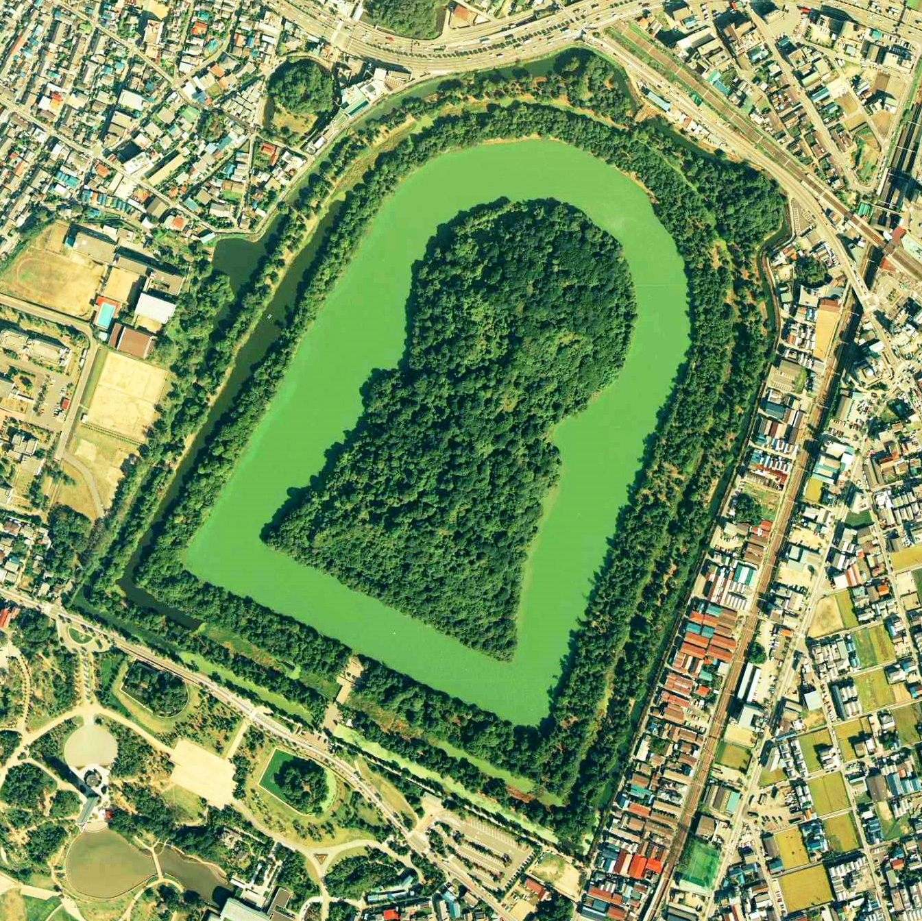
Daisen-kofun in Sakai, Osaka, Japan. This is one of the largest tombs in the world. Japanese government regards this as the tomb of Emperor Nintoku, the 16th emperor, but many historians don't think so. The keyhole-like tomb is 486m long, 305m wide at the bottom and 245m in diameter. English: Daisen-Kofun, the tomb of Emperor Nintoku, Osaka
Español: El Daisen-Kofun, tumba legendaria de Emperador Nintoku
Suomi: Kofun-kauden hautakumpu Osakassa, yksi maailman suurimmista. |
| Date | |
| Source | http://w3land.mlit.go.jp/cgi-bin/WebGIS2/WC_AirPhoto.cgi?IT=p&DT=n&PFN=CKK-85-2&PCN=C2&IDX=8 |
| Author | Ministry of Land, Infrastructure and Transport Government of Japan & moja resized |
| Permission (Reusing this file) |
GFDL |
| Camera location | 34° 33′ 50.82″ N, 135° 29′ 14.88″ E | View this and other nearby images on: OpenStreetMap |
|---|
- 仁徳天皇陵とされる古墳
- ソース
- 整理番号:CKK852-C2-8
- 撮影:1985年(昭和60年)

|
The copyright holder of this file, the Ministry of Land, Infrastructure, Transport and Tourism of Japan, allows anyone to use it for any purpose, provided that the copyright holder is properly attributed. Redistribution, derivative work, commercial use, and all other use is permitted. |
Attribution:
Copyright © National Land Image Information (Color Aerial Photographs), Ministry of Land, Infrastructure, Transport and Tourism Attribution |
 |
This image is copyrighted by the Ministry of Land, Infrastructure, Transport and Tourism of Japan. For terms of use, see the stipulation to use of National Land Information (in Japanese) and message from MLIT (in Japanese and English). When you display this image on an article, include the following phrase in the description: "Made based on National Land Image Information (Color Aerial Photographs), Ministry of Land, Infrastructure, Transport and Tourism".
|
Captions
Add a one-line explanation of what this file represents
Items portrayed in this file
depicts
8 October 1985
34°33'50.821"N, 135°29'14.881"E
image/jpeg
File history
Click on a date/time to view the file as it appeared at that time.
| Date/Time | Thumbnail | Dimensions | User | Comment | |
|---|---|---|---|---|---|
| current | 09:19, 7 June 2020 | | 1,345 × 1,344 (2.38 MB) | 名古屋太郎 | 明るさ等変更 |
| 20:44, 17 August 2005 |  | 800 × 800 (515 KB) | Moja~commonswiki | {{Information| |Description=Daisen-kofun in Sakai, Osaka, Japan. This is one of the largest tombs in the world. Japanese gorvernment regards this as the tomb of Emperor Nintoku, the 16th emperor, but many historians doubt don't think so. The keyhole-lik |
File usage
The following pages on the English Wikipedia use this file (pages on other projects are not listed):
Global file usage
The following other wikis use this file:
- Usage on fr.wikipedia.org
- Usage on ja.wikipedia.org
- Usage on www.wikidata.org
- Usage on zh.wikipedia.org
Metadata
This file contains additional information, probably added from the digital camera or scanner used to create or digitize it.
If the file has been modified from its original state, some details may not fully reflect the modified file.
| Camera model | RC10 |
|---|---|
| Date and time of data generation | 09:29, 8 October 1985 |
| Latitude | 34° 33′ 50.82″ N |
| Longitude | 135° 29′ 14.88″ E |
| Altitude | 1,820 meters above sea level |
| Orientation | Normal |
| Horizontal resolution | 72 dpi |
| Vertical resolution | 72 dpi |
| Software used | PENTAX PHOTO Browser Ver. 3.61 |
| File change date and time | 18:14, 7 June 2020 |
| Y and C positioning | Co-sited |
| Exif version | 2.21 |
| Date and time of digitizing | 09:29, 8 October 1985 |
| Meaning of each component |
|
| Supported Flashpix version | 1 |
| Color space | sRGB |
| Geodetic survey data used | WGS84 |
| GPS tag version | 2.0.0.0 |
Retrieved from "https://en.wikipedia.org/wiki/File:NintokuTomb.jpg"