File:NS_administrative_Gliederung_1944.png
From Wikipedia, the free encyclopedia
Original file (8,000 × 6,094 pixels, file size: 4.14 MB, MIME type: image/png)
| This is a file from the Wikimedia Commons. Information from its description page there is shown below. Commons is a freely licensed media file repository. You can help. |

|
This locator map image could be re-created using vector graphics as an SVG file. This has several advantages; see Commons:Media for cleanup for more information. If an SVG form of this image is available, please upload it and afterwards replace this template with
{{vector version available|new image name}}.
It is recommended to name the SVG file “NS administrative Gliederung 1944.svg”—then the template Vector version available (or Vva) does not need the new image name parameter. |
Summary
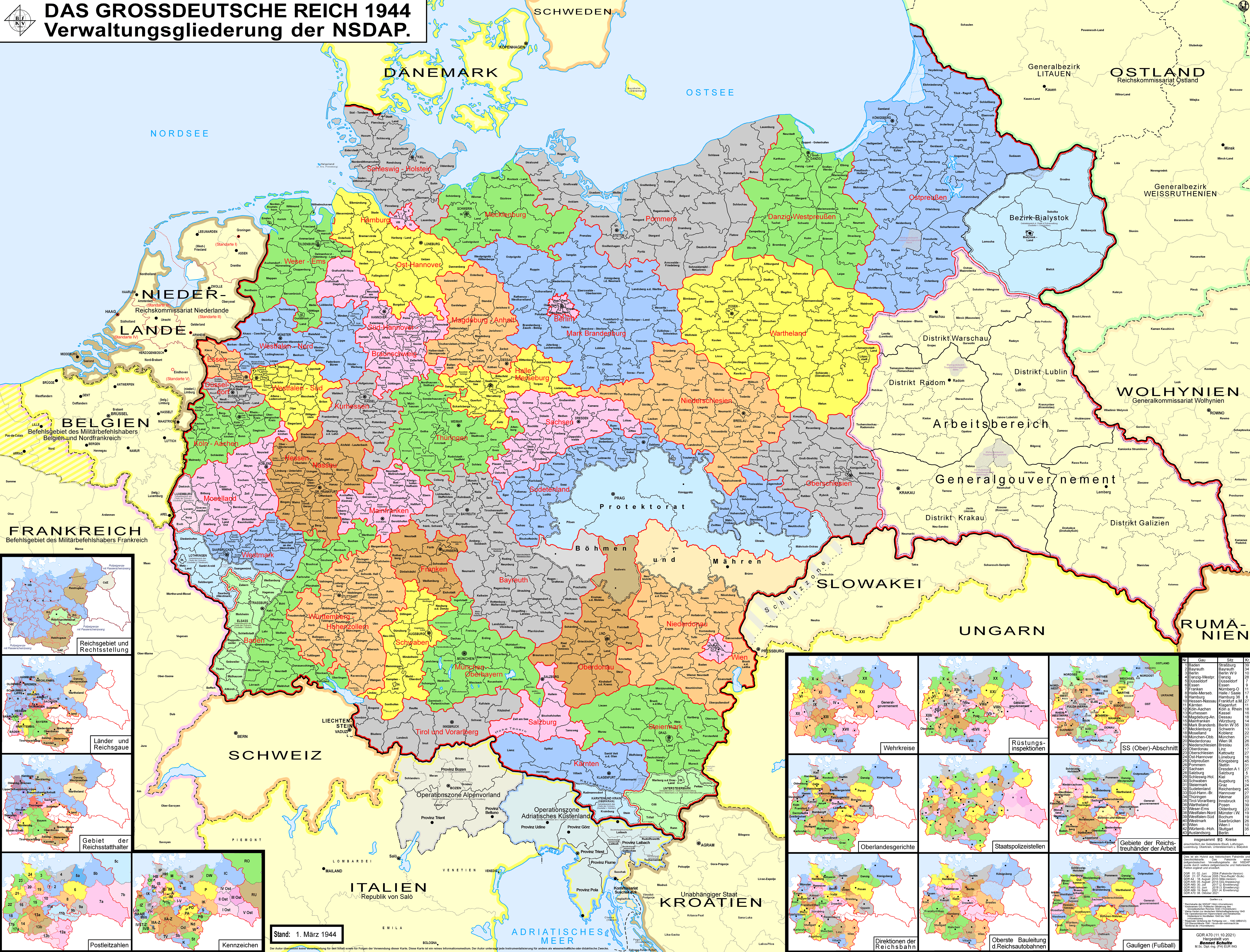
| DescriptionNS administrative Gliederung 1944.png |
Беларуская (тарашкевіца): Мапа адміністрацыйна-тэрытарыяльнага падзелу Вялікага нямецкага райху паводле НСДАП (1944).
Deutsch: Karte der Verwaltungsgliederung des Großdeutschen Reiches durch die NSDAP 1944. Sie zeigt die Kreise, Gaue und Reichsgaue der NSDAP. Zudem die Länder, die Gebiete der Reichsstatthalter und die Rechtsstellung der Reichsteile. Zusätzlich Postleitzahlen, Kennzeichen, Wehrkreise, Oberlandesgerichte, Staatspolizeistellen, Direktionen der Reichsbahn, Oberste Bauleitung der Reichsautobahnen und Arbeitsamtsgebiete 1944.
English: Map of the administrative division of the Greater German Reich (»Großdeutsches Reich«/»Großdeutschland«/"Greater German Empire"/"Greater Germany") by the NSDAP (Nazi Party) 1944, showing Kreise, Gaue and Reichsgaue. In addition, the states, the territories of the Reichsstatthalter and the legal status of Reich territories. Additionally postal codes, license plates, military districts, higher regional courts, State Police offices, railway directorates, Supreme construction management of the highways and work coordination areas 1944.
Polski: Mapa Wielkiej Rzeszy Niemieckiej (1944)
Русский: Административно-территориальное деление Третьего Рейха - Великой Германии (1944)
Українська: Адміністративно-територіальний поділ Третього Рейху - Великої Німеччини (1944) |
||
| Date | |||
| Source | Own work | ||
| Author | Bennet Schulte | ||
| Permission (Reusing this file) |
This file is licensed under the Creative Commons Attribution-Share Alike 3.0 Germany license.
 |
||
| Other versions |
|


| Annotations InfoField | This image is annotated: View the annotations at Commons |
Distrikt Galizien
Partei-Gau/Reichsgau Wartheland
Distrikt Warschau
Partei-Gau Ostpreußen
Distrikt Lublin
Distrikt Radom
Distirkt Krakau
Partei-Gau Oberschlesien
Partei-Gau Niederschlesien
Partei-Gau/Reichsgau Sudetenland
Captions
Items portrayed in this file
depicts
some value
18 August 2010
image/png
File history
Click on a date/time to view the file as it appeared at that time.
| Date/Time | Thumbnail | Dimensions | User | Comment | |
|---|---|---|---|---|---|
| current | 03:32, 12 October 2021 | | 8,000 × 6,094 (4.14 MB) | Exec | resolution reduzed |
| 03:31, 12 October 2021 |  | 17,392 × 13,248 (4.99 MB) | Exec | -render modus of previous version fixed | |
| 13:09, 11 October 2021 |  | 8,000 × 6,094 (7.98 MB) | Exec | - Lublin-Galicia-Adjustment implemented, Galicia internal boundaries redone, modifications at Desitrikt Bialystok | |
| 10:36, 6 October 2021 |  | 8,000 × 6,094 (22.08 MB) | Kamilhrub | Corrected name Hrubieszow and southern borders of Bilgoraj, Hrubieszow and Zamosc districts, which didn't change after 1941 (source: Amtliches Gemeinde- und Dorfverzeichnis für das Generalgouvernement auf Grund der Summarischen Bevölkerungsbestandsaufnahme am 1. März 1943) | |
| 22:27, 19 September 2021 |  | 8,000 × 6,094 (19.36 MB) | Exec | content exansion on multiple aspects | |
| 22:15, 19 September 2021 |  | 8,000 × 6,094 (8.37 MB) | Exec | inhaltliche Erweiterung verschiedenster Art | |
| 00:33, 21 February 2021 |  | 8,000 × 6,094 (22.22 MB) | Exec | - additional small map of Wehrinspektionen; minor corrections | |
| 14:57, 12 April 2019 |  | 8,000 × 6,094 (3.46 MB) | FDRMRZUSA | Lower resolution but better display: no more display problems and same image quality. Previous file too big: bigger dimensions not necessary. Reduced size: compressed and optimized. No other changes. | |
| 21:54, 5 June 2018 |  | 17,392 × 13,248 (11.47 MB) | Exec | - another color correction | |
| 21:33, 5 June 2018 |  | 17,366 × 13,226 (11.46 MB) | Exec | Color Error Correction |
File usage
- Administrative divisions of Nazi Germany
- Allgemeine-SS regional commands
- Bialystok District
- Gau (territory)
- Gau Baden
- Gau Bayreuth
- Gau Berlin
- Gau Cologne-Aachen
- Gau Düsseldorf
- Gau Eastern Hanover
- Gau Electoral Hesse
- Gau Essen
- Gau Franconia
- Gau Halle-Merseburg
- Gau Hamburg
- Gau Hesse-Nassau
- Gau Lower Silesia
- Gau Magdeburg-Anhalt
- Gau Main Franconia
- Gau March of Brandenburg
- Gau Mecklenburg
- Gau Moselland
- Gau Munich-Upper Bavaria
- Gau Pomerania
- Gau Saxony
- Gau Schleswig-Holstein
- Gau Silesia
- Gau Southern Hanover-Brunswick
- Gau Swabia
- Gau Thuringia
- Gau Upper Silesia
- Gau Weser-Ems
- Gau Westmark
- Gau Westphalia-North
- Gau Westphalia-South
- Gau Württemberg-Hohenzollern
- Gauliga
- Gauliga Böhmen und Mähren
- Gauliga Danzig-Westpreußen
- Gauliga Elsaß
- Gauliga Generalgouvernement
- Gauliga Ostmark
- Gauliga Sudetenland
- Gauliga Wartheland
- Hilarius Breitinger
- History of Bavaria
- Names of Germany
- Nazi Germany
- Nazi Party
- Pan-Germanism
- Polish areas annexed by Nazi Germany
- Reichsgau
- Reichsgau Danzig-West Prussia
- Reichsgau Kärnten
- Reichsgau Niederdonau
- Reichsgau Oberdonau
- Reichsgau Salzburg
- Reichsgau Steiermark
- Reichsgau Sudetenland
- Reichsgau Tirol-Vorarlberg
- Reichsgau Wartheland
- Reichsgau Wien
- Trustee of Labour
- Talk:Nazi Germany/Archive 6
- User:Arnaud.ramey/GlamFiltered
- User:Chickstarr404/Gather lists/13386 – "A Travelers Alphabet" by Stephen Runciman
- User:Falcaorib
- User:Ioscat/sandbox
- User:OddHerring/sandbox
- Wikipedia:Village pump (technical)/Archive 144
- Wikipedia:WikiProject Jewish history/Related projects
Global file usage
The following other wikis use this file:
- Usage on af.wikipedia.org
- Usage on an.wikipedia.org
- Usage on ar.wikipedia.org
- Usage on ast.wikipedia.org
- Usage on azb.wikipedia.org
- Usage on ba.wikipedia.org
- Usage on be-tarask.wikipedia.org
- Usage on be.wikipedia.org
- Usage on bg.wikipedia.org
- Usage on bn.wikipedia.org
- Usage on br.wikipedia.org
- Usage on bs.wikipedia.org
- Usage on ca.wikipedia.org
- Protectorat de Bohèmia i Moràvia
- Potències de l'Eix
- Partit Nacionalsocialista Alemany dels Treballadors
- Zona d'Operacions dels Prealps
- Gauleiter
- Gran Alemanya
- Govern General
- Divisions administratives de l'Alemanya nazi
- Zona d'Operacions del Litoral Adriàtic
- Viquipèdia:Estat Lliure de Prússia
- Usuari:Casablanca~cawiki/Estat Lliure de Prússia
- Reichsgau
- Gau de Magdeburg-Anhalt
- Gau de Halle-Merseburg
- Gau de Baden
- Gau de Württemberg-Hohenzollern
- Gau de Bayreuth
- Gau de Francònia
- Gau de Main-Francònia
- Gau de Múnic-Alta Baviera
- Gau de Suàbia
- Gau de Hannover del Sud-Brunsvic
- Gau de Hannover Oriental
- Gau de Turíngia
- Gau de Mecklenburg
View more global usage of this file.
Metadata
This file contains additional information, probably added from the digital camera or scanner used to create or digitize it.
If the file has been modified from its original state, some details may not fully reflect the modified file.
| Software used |
|---|