File:Maya_Block_USGS_OF-97-470-L_1-2.tif
From Wikipedia, the free encyclopedia

Size of this PNG preview of this TIF file: 502 × 599 pixels. Other resolutions: 201 × 240 pixels | 402 × 480 pixels | 643 × 768 pixels | 858 × 1,024 pixels | 1,716 × 2,048 pixels | 4,044 × 4,826 pixels.
Original file (4,044 × 4,826 pixels, file size: 80 MB, MIME type: image/tiff)
| This is a file from the Wikimedia Commons. Information from its description page there is shown below. Commons is a freely licensed media file repository. You can help. |
Summary
| DescriptionMaya Block USGS OF-97-470-L 1-2.tif |
English: French, C.D. and Schenk, C.J., 2006, Map showing geology, oil and gas fields, and geologic provinces of the Gulf of Mexico region: U.S. Geological Survey Open-File Report 97-470-L, https://doi.org/10.3133/ofr97470L. |
| Date | |
| Source | https://doi.org/10.3133/ofr97470L |
| Author | Christopher D. French and Christopher J. Schenk |
Licensing
| Public domainPublic domainfalsefalse |
This work is in the public domain in the United States because it is a work prepared by an officer or employee of the United States Government as part of that person’s official duties under the terms of Title 17, Chapter 1, Section 105 of the US Code.
Note: This only applies to original works of the Federal Government and not to the work of any individual U.S. state, territory, commonwealth, county, municipality, or any other subdivision. This template also does not apply to postage stamp designs published by the United States Postal Service since 1978. (See § 313.6(C)(1) of Compendium of U.S. Copyright Office Practices). It also does not apply to certain US coins; see The US Mint Terms of Use.
|
 | |
| This file has been identified as being free of known restrictions under copyright law, including all related and neighboring rights. | ||
https://creativecommons.org/publicdomain/mark/1.0/PDMCreative Commons Public Domain Mark 1.0falsefalse
Captions
Geologic provinces in the Maya Block / detail of 2006 map by USGS
Items portrayed in this file
depicts
2006
image/tiff
File history
Click on a date/time to view the file as it appeared at that time.
| Date/Time | Thumbnail | Dimensions | User | Comment | |
|---|---|---|---|---|---|
| current | 21:15, 18 June 2022 | 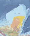 | 4,044 × 4,826 (80 MB) | Asdfjrjjj | Uploaded a work by Christopher D. French and Christopher J. Schenk from https://doi.org/10.3133/ofr97470L with UploadWizard |
File usage
The following pages on the English Wikipedia use this file (pages on other projects are not listed):
Metadata
This file contains additional information, probably added from the digital camera or scanner used to create or digitize it.
If the file has been modified from its original state, some details may not fully reflect the modified file.
| Image title | Map showing geology, oil and gas fields, and geologic provinces of the Gulf of Mexico region |
|---|---|
| Author | "French, C.D., and Schenk, C.J." |
| Width | 4,044 px |
| Height | 4,826 px |
| Compression scheme | Uncompressed |
| Pixel composition | RGB |
| Orientation | Normal |
| Number of components | 4 |
| Horizontal resolution | 300 dpi |
| Vertical resolution | 300 dpi |
| Data arrangement | chunky format |