File:MapofEmergingUSMegaregions.png
From Wikipedia, the free encyclopedia
Original file (2,494 × 1,662 pixels, file size: 1.55 MB, MIME type: image/png)
| This is a file from the Wikimedia Commons. Information from its description page there is shown below. Commons is a freely licensed media file repository. You can help. |

|
This map image could be re-created using vector graphics as an SVG file. This has several advantages; see Commons:Media for cleanup for more information. If an SVG form of this image is available, please upload it and afterwards replace this template with
{{vector version available|new image name}}.
It is recommended to name the SVG file “MapofEmergingUSMegaregions.svg”—then the template Vector version available (or Vva) does not need the new image name parameter. |
| DescriptionMapofEmergingUSMegaregions.png |
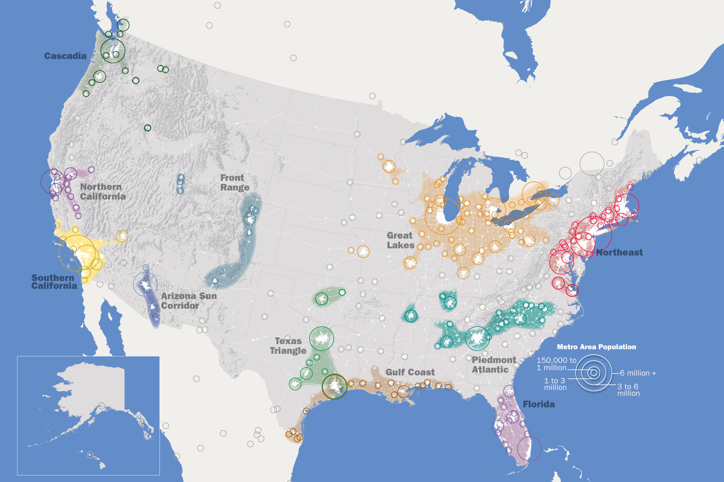
English: This map, created by the Regional Plan Association, illustrates eleven metropolitan areas that are growing into megaregions. |
||
| Date | |||
| Source | Own work, https://web.archive.org/web/20130325033001/http://www.rpa.org/america2050/sync/elements/america2050map.png | ||
| Author | IrvingPlNYC | ||
| Permission (Reusing this file) |
I, the copyright holder of this work, hereby publish it under the following license: This file is licensed under the Creative Commons Attribution-Share Alike 3.0 Unported license.
|
||
| Other versions |
Derivative works of this file: |
| Annotations InfoField | This image is annotated: View the annotations at Commons |
Captions
Items portrayed in this file
depicts
some value
2008
image/png
File history
Click on a date/time to view the file as it appeared at that time.
| Date/Time | Thumbnail | Dimensions | User | Comment | |
|---|---|---|---|---|---|
| current | 22:14, 6 September 2019 | | 2,494 × 1,662 (1.55 MB) | Concord19 | Map size and resolution improved. Title removed as redundant, and to present a cleaner look for the encyclopedia. |
| 00:36, 23 May 2018 |  | 1,200 × 800 (653 KB) | Howpper | Updated; metro reached 150k | |
| 06:28, 7 March 2017 |  | 1,200 × 800 (726 KB) | Howpper | Slight correction. | |
| 15:51, 3 September 2010 |  | 1,200 × 800 (610 KB) | Tryphon | Removed watermark. | |
| 14:05, 8 September 2009 |  | 1,200 × 800 (650 KB) | IrvingPlNYC | {{Information |Description={{en|1=This map, created by the Regional Plan Association, illustrates eleven metropolitan areas that are growing into megaregions.}} |Source=Own work by uploader |Author=IrvingPlNYC |Date= |Permission= |oth |
File usage
- Arizona Sun Corridor
- California megapolitan areas
- Great Lakes megalopolis
- Megaregions of the United States
- Northeast megalopolis
- Piedmont Atlantic megaregion
- Rust Belt
- Southern Rocky Mountain Front
- Talk:Great Lakes Megalopolis/Archive 1
- Talk:Great Lakes megalopolis
- User:Jhenderson777/ megaregion
- User talk:Jackmcbarn/Archive 19
- Wikipedia:Graphics Lab/Map workshop/Archive/Aug 2020
- Module:Location map/data/megaregion of United States
- Module:Location map/data/megaregion of United States/doc
Global file usage
The following other wikis use this file:
- Usage on ast.wikipedia.org
- Usage on da.wikipedia.org
- Usage on de.wikipedia.org
- Usage on es.wikipedia.org
- Usage on et.wikipedia.org
- Usage on eu.wikipedia.org
- Usage on fa.wikipedia.org
- Usage on fr.wikipedia.org
- Usage on he.wikipedia.org
- Usage on id.wikipedia.org
- Usage on it.wikipedia.org
- Usage on ja.wikipedia.org
- Usage on nl.wiktionary.org
- Usage on no.wikipedia.org
- Usage on pt.wikipedia.org
- Usage on ro.wikipedia.org
- Usage on ru.wikipedia.org
- Usage on si.wikipedia.org
- Usage on sl.wikipedia.org
- Usage on uk.wikipedia.org
- Usage on uz.wikipedia.org
- Usage on xmf.wikipedia.org
- Usage on zh.wikipedia.org
Metadata
This file contains additional information, probably added from the digital camera or scanner used to create or digitize it.
If the file has been modified from its original state, some details may not fully reflect the modified file.
| Horizontal resolution | 59.06 dpc |
|---|---|
| Vertical resolution | 59.06 dpc |
| File change date and time | 22:03, 6 September 2019 |