File:Map_of_Taungoo_Empire_(1580).png
From Wikipedia, the free encyclopedia
Size of this preview: 508 × 599 pixels. Other resolutions: 203 × 240 pixels | 407 × 480 pixels | 950 × 1,121 pixels.
Original file (950 × 1,121 pixels, file size: 1.5 MB, MIME type: image/png)
| This is a file from the Wikimedia Commons. Information from its description page there is shown below. Commons is a freely licensed media file repository. You can help. |
Contents
Summary
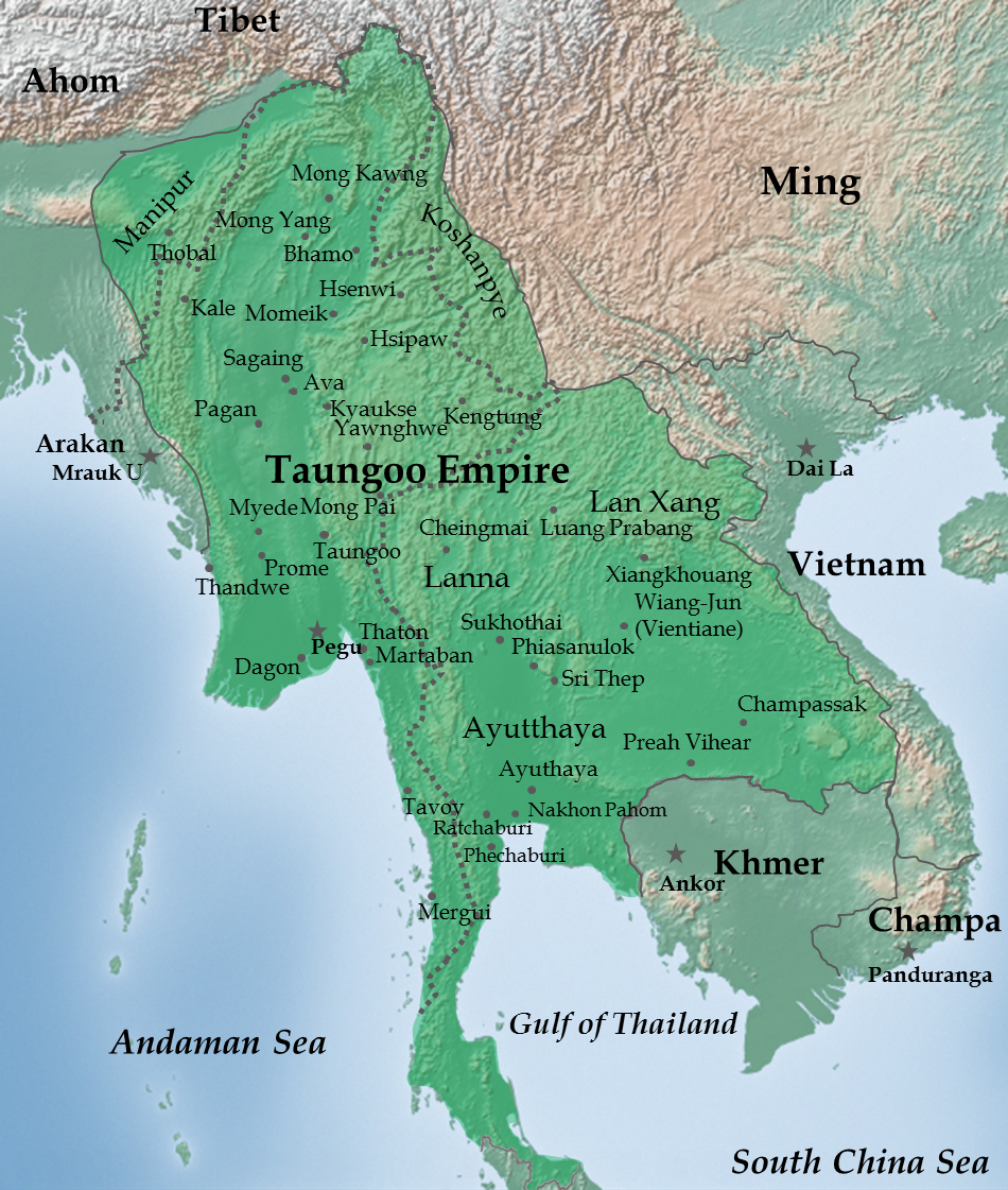
| DescriptionMap of Taungoo Empire (1580).png |
English: Taungoo Empire at its highest extent during the reign of King Bayinnaung (1551-1581) |
| Date | |
| Source | Own work. Background map is taken from www.naturalearthdata.com (public domain: Terms of Use). |
| Author | Soewinhan |
References

Refer to the
- timemap from University of California, Berkeley archive copy at the Wayback Machine for the extent of Ayutthaya, Lang Xang and Lanna before Bayinnaung's conquest.
- Victor B. Lieberman (2003) Strange parallels: Southeast Asia in global context, c 800-1830, Volume 1, pp. 152 ISBN: 0521804965. for the extent of Taungoo Empire as of 1580.
- File:Map of Toungoo Kingdom 1572.jpg and File:Map-of-southeast-asia 900 CE.png for geographic names.
- Baker, Chris. Phongpaichit, Pasuk. A History of Ayutthaya: Siam in the Early Modern World.
Notes
- The borders at that times were not demarcated. As stated in Berkeley timemap: The level of details present in some boundaries should not be interpreted as a result of a precise, detailed understanding of the borders of states during this period.
Licensing
I, the copyright holder of this work, hereby publish it under the following license:
This file is licensed under the Creative Commons Attribution-Share Alike 3.0 Unported license.
- You are free:
- to share – to copy, distribute and transmit the work
- to remix – to adapt the work
- Under the following conditions:
- attribution – You must give appropriate credit, provide a link to the license, and indicate if changes were made. You may do so in any reasonable manner, but not in any way that suggests the licensor endorses you or your use.
- share alike – If you remix, transform, or build upon the material, you must distribute your contributions under the same or compatible license as the original.
Captions
Add a one-line explanation of what this file represents
Items portrayed in this file
depicts
21 December 2011
image/png
File history
Click on a date/time to view the file as it appeared at that time.
| Date/Time | Thumbnail | Dimensions | User | Comment | |
|---|---|---|---|---|---|
| current | 02:28, 14 July 2023 | | 950 × 1,121 (1.5 MB) | Yourlocallordandsavior | Reverted to version as of 06:37, 14 February 2023 (UTC) |
| 06:42, 14 February 2023 |  | 950 × 1,121 (1.66 MB) | Yourlocallordandsavior | Reverted to version as of 02:30, 12 February 2023 (UTC) | |
| 06:37, 14 February 2023 |  | 950 × 1,121 (1.5 MB) | Yourlocallordandsavior | Reverted to version as of 07:39, 21 February 2013 (UTC) | |
| 02:30, 12 February 2023 |  | 950 × 1,121 (1.66 MB) | Yourlocallordandsavior | Ayutthaya did not exert its influence down the peninsula in the 16th century. | |
| 07:39, 21 February 2013 |  | 950 × 1,121 (1.5 MB) | Super Rad! | Cropped 1-px transparent border on left and blue border on bottom; reduced image size using PNGOUT | |
| 06:25, 22 December 2011 |  | 951 × 1,124 (2.31 MB) | Soewinhan | ||
| 13:33, 20 December 2011 |  | 951 × 1,118 (2.29 MB) | Soewinhan |
File usage
The following pages on the English Wikipedia use this file (pages on other projects are not listed):
Global file usage
The following other wikis use this file:
- Usage on ar.wikipedia.org
- Usage on azb.wikipedia.org
- Usage on ba.wikipedia.org
- Usage on bn.wikipedia.org
- Usage on ca.wikipedia.org
- Usage on cs.wikipedia.org
- Usage on es.wikipedia.org
- Usage on eu.wikipedia.org
- Usage on id.wikipedia.org
- Usage on it.wikipedia.org
- Usage on ja.wikipedia.org
- Usage on km.wikipedia.org
- Usage on ko.wikipedia.org
- Usage on lt.wikipedia.org
- Usage on mni.wikipedia.org
- Usage on my.wikipedia.org
- Usage on no.wikipedia.org
- Usage on pa.wikipedia.org
- Usage on pl.wikipedia.org
- Usage on pt.wikipedia.org
- Usage on ru.wikipedia.org
- Usage on sl.wikipedia.org
- Usage on sr.wikipedia.org
- Usage on szy.wikipedia.org
- Usage on th.wikipedia.org
View more global usage of this file.
.png)
Metadata
This file contains additional information, probably added from the digital camera or scanner used to create or digitize it.
If the file has been modified from its original state, some details may not fully reflect the modified file.
| Horizontal resolution | 59.05 dpc |
|---|---|
| Vertical resolution | 59.05 dpc |
Retrieved from "https://en.wikipedia.org/wiki/File:Map_of_Taungoo_Empire_(1580).png"
.png)