File:Mackenzie_River_basin_map.png
From Wikipedia, the free encyclopedia
Original file (1,222 × 1,122 pixels, file size: 2.11 MB, MIME type: image/png)
| This is a file from the Wikimedia Commons. Information from its description page there is shown below. Commons is a freely licensed media file repository. You can help. |
Summary
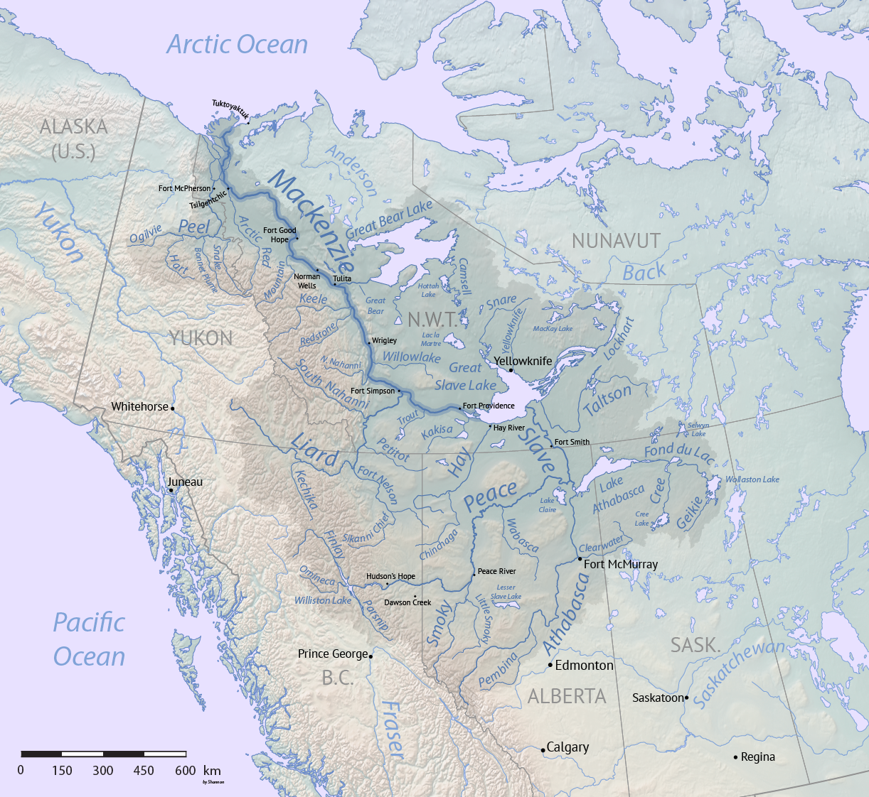
| DescriptionMackenzie River basin map.png |
English: Map of the Mackenzie River system in Canada, made using public domain Natural Earth and Atlas of Canada data. |
| Date | |
| Source | Own work |
| Author | Shannon1 |
⧼Iicense-header⧽

|
Permission is granted to copy, distribute and/or modify this document under the terms of the GNU Free Documentation License, Version 1.2 or any later version published by the Free Software Foundation; with no Invariant Sections, no Front-Cover Texts, and no Back-Cover Texts. A copy of the license is included in the section entitled GNU Free Documentation License.http://www.gnu.org/copyleft/fdl.htmlGFDLGNU Free Documentation Licensetruetrue |
If this file is eligible for relicensing, it may also be used under the Creative Commons Attribution-ShareAlike 3.0 license. The relicensing status of this image has not yet been reviewed. You can help. العربية ∙ azərbaycanca ∙ беларуская (тарашкевіца) ∙ български ∙ বাংলা ∙ català ∙ čeština ∙ Deutsch ∙ Deutsch (Sie-Form) ∙ English ∙ español ∙ eesti ∙ فارسی ∙ suomi ∙ français ∙ galego ∙ עברית ∙ hrvatski ∙ magyar ∙ italiano ∙ 日本語 ∙ 한국어 ∙ lietuvių ∙ македонски ∙ മലയാളം ∙ Bahasa Melayu ∙ Nederlands ∙ occitan ∙ português ∙ português do Brasil ∙ română ∙ русский ∙ sicilianu ∙ slovenščina ∙ српски / srpski ∙ svenska ∙ Türkçe ∙ ไทย ∙ українська ∙ Tiếng Việt ∙ 简体中文 ∙ 繁體中文 ∙ +/− |
- You are free:
- to share – to copy, distribute and transmit the work
- to remix – to adapt the work
- Under the following conditions:
- attribution – You must give appropriate credit, provide a link to the license, and indicate if changes were made. You may do so in any reasonable manner, but not in any way that suggests the licensor endorses you or your use.
- share alike – If you remix, transform, or build upon the material, you must distribute your contributions under the same or compatible license as the original.
Captions
Items portrayed in this file
depicts
1 November 2017
image/png
File history
Click on a date/time to view the file as it appeared at that time.
| Date/Time | Thumbnail | Dimensions | User | Comment | |
|---|---|---|---|---|---|
| current | 22:34, 1 November 2017 | | 1,222 × 1,122 (2.11 MB) | Shannon1 | {{Information |Description ={{en|1=Map of the Mackenzie River system in Canada, made using public domain Natural Earth and Atlas of Canada data.}} |Source =Own work |Author =Shannon1 |Date =November 1, 201... |
File usage
Global file usage
The following other wikis use this file:
- Usage on ast.wikipedia.org
- Usage on bh.wikipedia.org
- Usage on cs.wikipedia.org
- Usage on de.wikipedia.org
- Usage on es.wikipedia.org
- Usage on et.wikipedia.org
- Usage on fr.wikipedia.org
- Usage on ja.wikipedia.org
- Usage on ml.wikipedia.org
- Usage on sl.wikipedia.org
- Usage on uz.wikipedia.org
- Usage on xmf.wikipedia.org
Metadata
This file contains additional information, probably added from the digital camera or scanner used to create or digitize it.
If the file has been modified from its original state, some details may not fully reflect the modified file.
| Software used | Adobe ImageReady |
|---|---|
| Horizontal resolution | 59.06 dpc |
| Vertical resolution | 59.06 dpc |