File:Krainy-historyczne-Polski.png
From Wikipedia, the free encyclopedia
Size of this preview: 600 × 600 pixels. Other resolutions: 240 × 240 pixels | 480 × 480 pixels | 768 × 768 pixels | 1,024 × 1,024 pixels | 2,048 × 2,048 pixels | 4,961 × 4,961 pixels.
Original file (4,961 × 4,961 pixels, file size: 13.65 MB, MIME type: image/png)
| This is a file from the Wikimedia Commons. Information from its description page there is shown below. Commons is a freely licensed media file repository. You can help. |
Summary
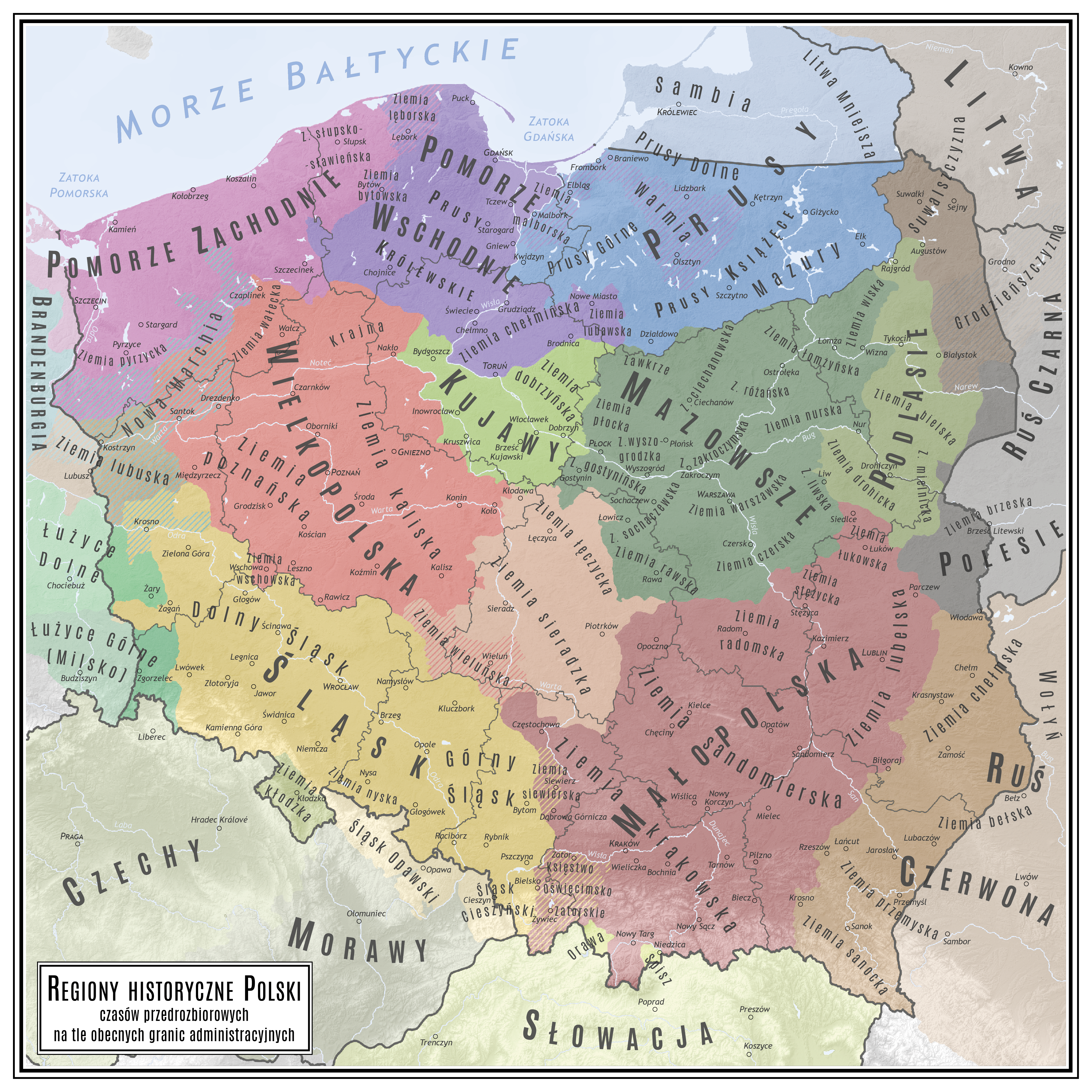
| DescriptionKrainy-historyczne-Polski.png |
Polski: Krainy historyczne Polski w obecnych granicach administracyjnych
English: Historical regions in present-day Poland |
| Date | |
| Source | Own work |
| Author | Netzach |
Licensing
I, the copyright holder of this work, hereby publish it under the following license:
This file is licensed under the Creative Commons Attribution-Share Alike 4.0 International license.
- You are free:
- to share – to copy, distribute and transmit the work
- to remix – to adapt the work
- Under the following conditions:
- attribution – You must give appropriate credit, provide a link to the license, and indicate if changes were made. You may do so in any reasonable manner, but not in any way that suggests the licensor endorses you or your use.
- share alike – If you remix, transform, or build upon the material, you must distribute your contributions under the same or compatible license as the original.
Captions
Historical regions of Poland
Krainy historyczne Polski
Items portrayed in this file
depicts
25 January 2023
image/png
File history
Click on a date/time to view the file as it appeared at that time.
| Date/Time | Thumbnail | Dimensions | User | Comment | |
|---|---|---|---|---|---|
| current | 21:51, 16 March 2024 | | 4,961 × 4,961 (13.65 MB) | Netzach | more lands names |
| 22:25, 9 March 2024 |  | 4,961 × 4,961 (13.61 MB) | Netzach | border corrections, few towns more | |
| 09:46, 18 March 2023 |  | 4,961 × 4,961 (13.64 MB) | Netzach | +Milsko, some corrections | |
| 22:52, 26 January 2023 |  | 4,961 × 4,961 (13.69 MB) | Netzach | Small changes around Neumark | |
| 22:21, 25 January 2023 |  | 4,961 × 4,961 (13.67 MB) | Netzach | Uploaded own work with UploadWizard |
File usage
The following pages on the English Wikipedia use this file (pages on other projects are not listed):
- Bielsk Land
- Chełm Land
- Chełmno Land
- Ciechanów Land
- Cieszyn Silesia
- Czersk Land
- Drohiczyn Land
- Duchy of Sandomierz
- Greater Poland
- Greater Poland Voivodeship
- Kalisz Region
- Krajna
- Kraków Land
- Kuyavia
- Kuyavian–Pomeranian Voivodeship
- Lesser Poland
- Lesser Poland Voivodeship
- Liw Land
- Lower Silesia
- Lower Silesian Voivodeship
- Lubusz Land
- Lubusz Voivodeship
- Lusatia
- Masovian Voivodeship
- Masuria
- Mazovia
- Mielnik Land
- Nur Land
- Opole Voivodeship
- Podlachia
- Podlaskie Voivodeship
- Polesia
- Polish historical regions
- Pomerania
- Przemyśl Land
- Płock Land
- Rawa Land
- Red Ruthenia
- Regions of Poland
- Royal Prussia
- Różan Land
- Sanok Land
- Sieradz Land
- Silesia
- Silesian Voivodeship
- Sochaczew Land
- Stężyca Land
- Subcarpathian Voivodeship
- Upper Silesia
- Warmia
- Warsaw Land
- Wieluń Land
- Wizna Land
- Wschowa Land
- Wyszogród Land
- Zakroczym Land
- Zawkrze
- Łomża Land
- Łuków County
- Łódź Voivodeship
- Łęczyca Land
- User:Falcaorib
Global file usage
The following other wikis use this file:
- Usage on be.wikipedia.org
- Usage on cs.wikipedia.org
- Usage on de.wikipedia.org
- Usage on lt.wikipedia.org
- Usage on lv.wikipedia.org
- Usage on pl.wikipedia.org
View more global usage of this file.
Metadata
This file contains additional information, probably added from the digital camera or scanner used to create or digitize it.
If the file has been modified from its original state, some details may not fully reflect the modified file.
| Horizontal resolution | 118.11 dpc |
|---|---|
| Vertical resolution | 118.11 dpc |
Retrieved from "https://en.wikipedia.org/wiki/File:Krainy-historyczne-Polski.png"