File:Indonesia_provinces_english.png
From Wikipedia, the free encyclopedia
Size of this preview: 800 × 365 pixels. Other resolutions: 320 × 146 pixels | 640 × 292 pixels | 1,628 × 742 pixels.
Original file (1,628 × 742 pixels, file size: 92 KB, MIME type: image/png)
| This is a file from the Wikimedia Commons. Information from its description page there is shown below. Commons is a freely licensed media file repository. You can help. |


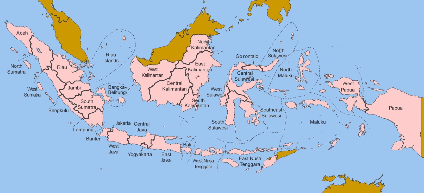
This file requires updating because: In 2022, the Papua provinces changed from 2 provinces to 6 provinces. In doing so, you could add a timestamp to the file.
|
Summary
Map of the provinces of Indonesia in English.
Made by User:Golbez based on a PD CIA map, using other sources to guesstimate the extent of West Irian Jaya and West Sulawesi.
derivative works
Derivative works of this file: Indonesia, administrative divisions - en - monochrome.svg
Licensing
I, the copyright holder of this work, hereby publish it under the following licenses:

|
Permission is granted to copy, distribute and/or modify this document under the terms of the GNU Free Documentation License, Version 1.2 or any later version published by the Free Software Foundation; with no Invariant Sections, no Front-Cover Texts, and no Back-Cover Texts. A copy of the license is included in the section entitled GNU Free Documentation License.http://www.gnu.org/copyleft/fdl.htmlGFDLGNU Free Documentation Licensetruetrue |
| This file is licensed under the Creative Commons Attribution-Share Alike 3.0 Unported license. | ||
| ||
| This licensing tag was added to this file as part of the GFDL licensing update.http://creativecommons.org/licenses/by-sa/3.0/CC BY-SA 3.0Creative Commons Attribution-Share Alike 3.0truetrue |
This file is licensed under the Creative Commons Attribution 2.5 Generic license.
- You are free:
- to share – to copy, distribute and transmit the work
- to remix – to adapt the work
- Under the following conditions:
- attribution – You must give appropriate credit, provide a link to the license, and indicate if changes were made. You may do so in any reasonable manner, but not in any way that suggests the licensor endorses you or your use.
You may select the license of your choice.
Captions
Add a one-line explanation of what this file represents
Items portrayed in this file
depicts
File history
Click on a date/time to view the file as it appeared at that time.
| Date/Time | Thumbnail | Dimensions | User | Comment | |
|---|---|---|---|---|---|
| current | 12:40, 25 October 2020 | | 1,628 × 742 (92 KB) | Afrogindahood | Addition of North Kalimantan province |
| 07:54, 8 January 2006 | 1,500 × 590 (77 KB) | Golbez | Map of the provinces of Indonesian in English. Made by User:Golbez based on a PD CIA map, using other sources to guesstimate the extent of West Irian Jaya and West Sulawesi. Category:Maps of Indonesia |
File usage
The following pages on the English Wikipedia use this file (pages on other projects are not listed):
Global file usage
The following other wikis use this file:
- Usage on arz.wikipedia.org
- Usage on ba.wikipedia.org
- Usage on be-tarask.wikipedia.org
- Usage on blk.wikipedia.org
- Usage on bxr.wikipedia.org
- Usage on ca.wikipedia.org
- Usage on ceb.wikipedia.org
- Usage on crh.wikipedia.org
- Usage on csb.wikipedia.org
- Usage on cs.wikipedia.org
- Usage on cy.wikipedia.org
- Usage on da.wikipedia.org
- Usage on diq.wikipedia.org
- Usage on dv.wikipedia.org
- Usage on es.wikipedia.org
- Usage on fr.wikipedia.org
- Usage on gd.wikipedia.org
- Usage on gl.wikipedia.org
- Usage on ht.wikipedia.org
- Usage on hu.wikipedia.org
- Usage on incubator.wikimedia.org
- Usage on it.wikipedia.org
- Usage on ja.wikipedia.org
- Usage on kaa.wikipedia.org
- Usage on kk.wikipedia.org
- Usage on km.wikipedia.org
- Usage on kn.wikipedia.org
- Usage on kv.wikipedia.org
- Usage on kw.wikipedia.org
- Usage on lij.wikipedia.org
- Usage on lmo.wikipedia.org
- Usage on ln.wikipedia.org
- Usage on lv.wikipedia.org
- Usage on mg.wikipedia.org
- Usage on mhr.wikipedia.org
- Usage on ml.wikipedia.org
- Usage on mn.wikipedia.org
- Usage on my.wikipedia.org
- Usage on mzn.wikipedia.org
- Usage on new.wikipedia.org
- Usage on nl.wikipedia.org
- Usage on nn.wikipedia.org
- Usage on pag.wikipedia.org
- Usage on pam.wikipedia.org
- Usage on pap.wikipedia.org
- Usage on pms.wikipedia.org
- Usage on pnb.wikipedia.org
- Usage on qu.wikipedia.org
View more global usage of this file.
Metadata
This file contains additional information, probably added from the digital camera or scanner used to create or digitize it.
If the file has been modified from its original state, some details may not fully reflect the modified file.
| Horizontal resolution | 59.04 dpc |
|---|---|
| Vertical resolution | 59.04 dpc |
Retrieved from "https://en.wikipedia.org/wiki/File:Indonesia_provinces_english.png"