File:Greatvalley-map.png
From Wikipedia, the free encyclopedia
Size of this preview: 587 × 599 pixels. Other resolutions: 235 × 240 pixels | 624 × 637 pixels.
Original file (624 × 637 pixels, file size: 66 KB, MIME type: image/png)
| This is a file from the Wikimedia Commons. Information from its description page there is shown below. Commons is a freely licensed media file repository. You can help. |
The factual accuracy of this map or the file name is disputed.
Reason: location of escarpment; see talk:Greatvalley-map.png. |  |
| Datasource (reference to visualized facts) is not provided for the data that is visualized in this self-made work. |

|
This map image could be re-created using vector graphics as an SVG file. This has several advantages; see Commons:Media for cleanup for more information. If an SVG form of this image is available, please upload it and afterwards replace this template with
{{vector version available|new image name}}.
It is recommended to name the SVG file “Greatvalley-map.svg”—then the template Vector version available (or Vva) does not need the new image name parameter. |
Summary
| DescriptionGreatvalley-map.png |
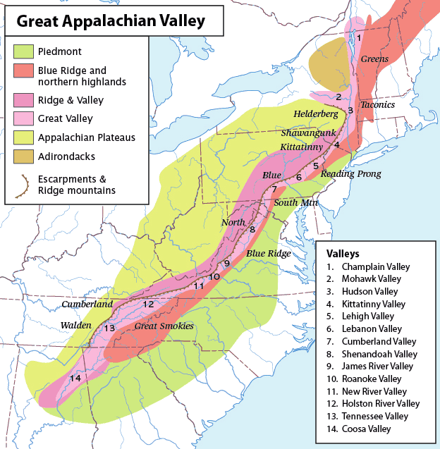
Map of the Appalachian Mountain physiographic regions, highlighting the Great Appalachian Valley, naming the main valleys making it up and the main mountains on either side. Legend:
|
| Date | (UTC) |
| Source | |
| Author |
|
| This is a retouched picture, which means that it has been digitally altered from its original version. Modifications: converted loselessto PNG. The original can be viewed here: Greatvalley-map.jpg:
|
I, the copyright holder of this work, hereby publish it under the following license:
This file is licensed under the Creative Commons Attribution-Share Alike 2.5 Generic license.
- You are free:
- to share – to copy, distribute and transmit the work
- to remix – to adapt the work
- Under the following conditions:
- attribution – You must give appropriate credit, provide a link to the license, and indicate if changes were made. You may do so in any reasonable manner, but not in any way that suggests the licensor endorses you or your use.
- share alike – If you remix, transform, or build upon the material, you must distribute your contributions under the same or compatible license as the original.
Original upload log
This image is a derivative work of the following images:
- File:Greatvalley-map.jpg licensed with Cc-by-sa-2.5
- 2006-11-14T06:22:37Z Pfly 624x637 (394372 Bytes) {{Information |Description=Map of the Appalachian Mountain physiographic regions, highlighting the Great Appalachian Valley, naming the main valleys making it up and the main mountains on either side. |Source=I made this map
Uploaded with derivativeFX
Captions
Add a one-line explanation of what this file represents
Items portrayed in this file
depicts
12 May 2010
File history
Click on a date/time to view the file as it appeared at that time.
| Date/Time | Thumbnail | Dimensions | User | Comment | |
|---|---|---|---|---|---|
| current | 15:00, 12 May 2010 | | 624 × 637 (66 KB) | Perhelion | {{Information |Description=Map of the Appalachian Mountain physiographic regions, highlighting the Great Appalachian Valley, naming the main valleys making it up and the main mountains on either side. |Source=*File:Greatvalley-map.jpg |Date=2010-05- |
File usage
The following pages on the English Wikipedia use this file (pages on other projects are not listed):
- Allegheny Front
- Cumberland Valley
- Gaps of the Allegheny
- Great Appalachian Valley
- Kittatinny Valley
- Lebanon Valley
- Lehigh Valley
- Washington County, New York
- Talk:Ridge-and-Valley Appalachians
- User:Hike395/mountain bot diff
- Template:Infobox mountain/test versus status quo ante 3
- Template:User Appalachian diaspora
Global file usage
The following other wikis use this file:
- Usage on bg.wikipedia.org
- Usage on bh.wikipedia.org
- Usage on ca.wikipedia.org
- Usage on cs.wikipedia.org
- Usage on da.wikipedia.org
- Usage on et.wikipedia.org
- Usage on fa.wikipedia.org
- Usage on fo.wikipedia.org
- Usage on frr.wikipedia.org
- Usage on fr.wikipedia.org
- Usage on he.wikipedia.org
- Usage on it.wikipedia.org
- Usage on ja.wikipedia.org
- Usage on lt.wikipedia.org
- Usage on ml.wikipedia.org
- Usage on pl.wikipedia.org
- Usage on simple.wikipedia.org
- Usage on uk.wikipedia.org
Retrieved from "https://en.wikipedia.org/wiki/File:Greatvalley-map.png"